 |
|
Coordinates: 42°32′35″N 083°10′40″W / 42.54306°N 83.17778°W / 42.54306; -83.17778
| Oakland/Troy Airport |
| IATA: none – ICAO: KVLL – FAA LID: VLL |
| Summary |
| Airport type |
Public |
| Owner |
Oakland County |
| Serves |
Troy, Michigan |
| Elevation AMSL |
729 ft / 222 m |
| Runways |
| Direction |
Length |
Surface |
| ft |
m |
| 9/27 |
3,550 |
1,082 |
Asphalt |
| Statistics (2006) |
| Aircraft operations |
32,466 |
| Source: Federal Aviation Administration |
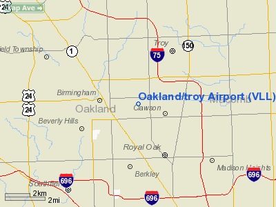
Oakland/Troy Airport (ICAO: KVLL, FAA LID: VLL) is a county-owned public-use airport located two miles (3 km) east of the central business district of Troy, a city in Oakland County, Michigan, United States.
The Oakland/Troy Airport is considered the county's 'executive' airport. Business travelers and tourists using private, corporate and charter aircraft benefit from the airport's convenient proximity to business, recreation and entertainment facilities. It is located between Maple Road and 14 Mile Road and Coolidge Highway and Crooks Road.
Although most U.S. airports use the same three-letter location identifier for the FAA and IATA, Oakland/Troy Airport is assigned VLL by the FAA but has no designation from the IATA (which assigned VLL to Valladolid, Spain).
Facilities and aircraft
Oakland/Troy Airport covers an area of 119 acres (48 ha) which contains one runway designated 9/27 with a 3,550 x 60 ft (1,082 x 18 m) asphalt pavement. For the 12-month period ending December 31, 2006, the airport had 32,466 general aviation aircraft operations, an average of 88 per day.
Charter passenger, air freight, as well as aircraft maintenance and fuel, are available on the field.
Other Airport Information: There are currently 108 aircraft based at Oakland/Troy Airport.
Single Engined Aircraft: 95
Multi Engined Aircraft: 10
Helicopters: 3
Jets: 0
(On occasion, a small jet may visit the airport)
The above content comes from Wikipedia and is published under free licenses – click here to read more.
Location & QuickFacts
| FAA Information Effective: | 2008-09-25 |
| Airport Identifier: | VLL |
| Airport Status: | Operational |
| Longitude/Latitude: | 083-10-40.4000W/42-32-34.6000N
-83.177889/42.542944 (Estimated) |
| Elevation: | 727 ft / 221.59 m (Surveyed) |
| Land: | 119 acres |
| From nearest city: | 2 nautical miles E of Troy, MI |
| Location: | Oakland County, MI |
| Magnetic Variation: | 06W (1995) |
Owner & Manager
| Ownership: | Publicly owned |
| Owner: | Oakland County |
| Address: | 6500 Highland Road
Waterford, MI 48327 |
| Phone number: | 248-666-3900
ARPT PHONE 248-288-6100. |
| Manager: | Karl W Randall |
| Address: | 6500 Highland Rd
Waterford, MI 48327 |
| Phone number: | 248-666-3900 |
Airport Operations and Facilities
| Airport Use: | Open to public |
| Wind indicator: | Yes
OTS INDEFLY. |
| Segmented Circle: | No |
| Control Tower: | No |
| Lighting Schedule: | DUSK-DAWN
ACTVT MIRL RY 09/27 & PAPI RYS 09 & 27 - CTAF. |
| Beacon Color: | Clear-Green (lighted land airport) |
| Landing fee charge: | Yes |
| Sectional chart: | Detroit |
| Region: | AGL - Great Lakes |
| Traffic Pattern Alt: | 1000 ft |
| Boundary ARTCC: | ZOB - Cleveland |
| Tie-in FSS: | LAN - Lansing |
| FSS on Airport: | No |
| FSS Toll Free: | 1-800-WX-BRIEF |
| NOTAMs Facility: | LAN (NOTAM-d service avaliable) |
| Federal Agreements: | N |
Airport Communications
| CTAF: | 123.050 |
| Unicom: | 123.050 |
Airport Services
| Fuel available: | 100LLA |
| Airframe Repair: | NONE |
| Power Plant Repair: | NONE |
Runway Information
Runway 09/27
| Dimension: | 3549 x 60 ft / 1081.7 x 18.3 m |
| Surface: | ASPH, Fair Condition |
| Edge Lights: | Medium |
| |
Runway 09 |
Runway 27 |
| Longitude: | 083-11-04.1355W | 083-10-16.7273W |
| Latitude: | 42-32-34.5584N | 42-32-34.7309N |
| Elevation: | 727.00 ft | 701.00 ft |
| Alignment: | 90 | 127 |
| Traffic Pattern: | Left | Left |
| Markings: | Non-precision instrument, Fair Condition | Non-precision instrument, Fair Condition |
| Crossing Height: | 30.00 ft | 31.00 ft |
| Displaced threshold: | 200.00 ft | 0.00 ft |
| VASI: | 2-light PAPI on right side | 2-light PAPI on left side |
| Visual Glide Angle: | 4.00° | 4.00° |
| Runway End Identifier: | No | No |
| Centerline Lights: | No | No |
| Touchdown Lights: | No | No |
| Obstruction: | 98 ft pline, 2230.0 ft from runway, 20:1 slope to clear
RY 09 APCH RATIO 24:1 TO DSPLCD THLD. | 17 ft bldg, 540.0 ft from runway, 20:1 slope to clear |
|
Radio Navigation Aids
| ID |
Type |
Name |
Ch |
Freq |
Var |
Dist |
| VQ | NDB | Cargl | | 230.00 | 05W | 15.0 nm |
| G | NDB | Golf | | 398.00 | 05W | 18.9 nm |
| QG | NDB | Windsor | | 353.00 | 06W | 19.5 nm |
| RYS | NDB | Grosse Ile | | 419.00 | 06W | 26.6 nm |
| OZW | NDB | Howell | | 243.00 | 05W | 36.3 nm |
| TCU | NDB | Tecumseh | | 239.00 | 04W | 43.6 nm |
| ZR | NDB | Sarnia | | 404.00 | 06W | 48.1 nm |
| MTC | TACAN | Selfridge | 064X | | 06W | 15.9 nm |
| DXO | VOR/DME | Detroit | 081X | 113.40 | 06W | 21.5 nm |
| YQG | VOR/DME | Windsor | 085X | 113.80 | 06W | 23.5 nm |
| PSI | VORTAC | Pontiac | 047X | 111.00 | 03W | 18.3 nm |
| SVM | VORTAC | Salem | 090X | 114.30 | 03W | 20.1 nm |
| CRL | VORTAC | Carleton | 104X | 115.70 | 03W | 32.2 nm |
| FNT | VORTAC | Flint | 116X | 116.90 | 06W | 35.8 nm |
| ECK | VORTAC | Peck | 087X | 114.00 | 07W | 47.4 nm |
| DET | VOT | Detroit City | | 111.60 | | 11.0 nm |
| DTW | VOT | Detroit Met Wayne | | 109.80 | | 20.7 nm |
| YIP | VOT | Willow Run | | 112.00 | | 24.1 nm |
Remarks
- DEER AND BIRDS ON & INVOF ARPT.
- RY 09 +3 FT BERM 316 FT FM THLD.
- NO TGL OR PRACTICE TFC PATTERNS.
Images and information placed above are from
http://www.airport-data.com/airport/VLL/
We thank them for the data!
| General Info |
| Country |
United States
|
| State |
MICHIGAN
|
| FAA ID |
VLL
|
| Time |
UTC-5(-4DT)
|
| Latitude |
42.542944
42° 32' 34.60" N
|
| Longitude |
-83.177908
083° 10' 40.47" W
|
| Elevation |
729 feet
222 meters
|
| Type |
Civil
|
| Magnetic Variation |
007° W (01/06)
|
| Beacon |
Yes
|
| Operating Agency |
U.S.CIVIL AIRPORT WHEREIN PERMIT COVERS USE BY TRANSIT MILITARY AIRCRAFT
|
| Near City |
Troy
|
| Operating Hours |
SEE REMARKS FOR OPERATING HOURS OR COMMUNICATIONS FOR POSSIBLE HOURS
|
| Daylight Saving Time |
Second Sunday in March at 0200 to first Sunday in November at 0200 local time (Exception Arizona and that portion of Indiana in the Eastern Time Zone)
|
We don't guarantee the information is fresh and accurate. The data may
be wrong or outdated.
For more up-to-date information please refer to other sources.
|
|


