 |
|
Oakland County International Airport |
| Oakland County International Airport |
| IATA: PTK – ICAO: KPTK – FAA LID: PTK |
| Summary |
| Airport type |
Public |
| Owner |
County of Oakland |
| Serves |
Pontiac, Michigan |
| Location |
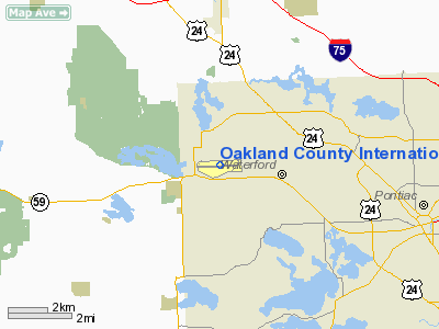
Waterford Township, Michigan |
| Elevation AMSL |
980 ft / 299 m |
| Coordinates |
42°39′56″N 083°25′10″W / 42.66556°N 83.41944°W / 42.66556; -83.41944 |
| Website |
oakgov.com/aviation/ |
| Runways |
| Direction |
Length |
Surface |
| ft |
m |
| 9R/27L |
6,200 |
1,890 |
Asphalt |
| 9L/27R |
5,000 |
1,524 |
Asphalt |
| 17/35 |
2,585 |
788 |
Asphalt |
| Statistics (2006) |
| Aircraft operations |
202,973 |
| Based aircraft |
500 |
| Source: Federal Aviation Administration |
Oakland County International Airport (IATA: PTK, ICAO: KPTK, FAA LID: PTK) is a county-owned public-use airport located in Waterford Township, Oakland County, Michigan, United States. The airport is five nautical miles (9 km) west of the central business district of Pontiac.
It is the sixth-busiest airport in the United States without scheduled passenger service. Charters carrying sports teams competing at the Palace of Auburn Hills nearby frequently use the airport. The airport was originally called Pontiac Municipal Airport when it opened in 1928.
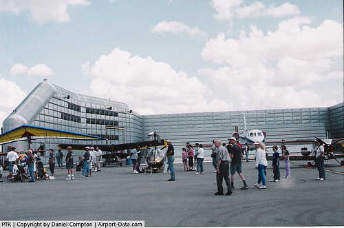
The airport holds an open house every year, showing aircraft based at PTK, military aircraft and vintage aircraft. The Civil Air Patrol acts as security for the open house. Facilities and aircraft
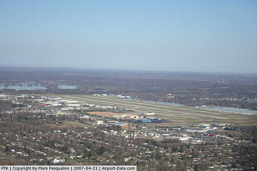
Oakland County International Airport covers an area of 750 acres (304 ha) at an elevation of 980 feet (299 m) above mean sea level. It has three asphalt paved runways: 9R/27L is 6,200 by 150 feet (1,890 x 46 m); 9L/27R is 5,000 by 100 feet (1,524 x 30 m); 17/35 is 2,585 by 75 feet (788 x 23 m). There are plans to extend 9R/27L so it is able to handle heavier aircraft.
For the 12-month period ending December 31, 2006, the airport had 202,973 aircraft operations, an average of 556 per day: 92% general aviation, 7% air taxi, 1% scheduled commercial and <1% military. At that time there were 500 aircraft based at this airport: 60% single-engine, 21% multi-engine, 16% jet, 2% helicopter, <1% glider and <1% ultralight.
Charter airlines
- Murray Air (Willow Run, Chicago Rockford, Kokomo) [mainly charters for Chrysler to their plants around the Midwest]
- Kalitta
The above content comes from Wikipedia and is published under free licenses – click here to read more.
|
 |
(Click on the photo to enlarge) |
|
 |
(Click on the photo to enlarge) |
|
 |
(Click on the photo to enlarge) |
|
 |
(Click on the photo to enlarge) |
Location & QuickFacts
| FAA Information Effective: | 2008-09-25 |
| Airport Identifier: | PTK |
| Airport Status: | Operational |
| Longitude/Latitude: | 083-25-10.4852W/42-39-56.2810N
-83.419579/42.665634 (Estimated) |
| Elevation: | 980 ft / 298.70 m (Surveyed) |
| Land: | 750 acres |
| From nearest city: | 5 nautical miles W of Pontiac, MI |
| Location: | Oakland County, MI |
| Magnetic Variation: | 04W (1980) |
Owner & Manager
| Ownership: | Publicly owned |
| Owner: | County Of Oakland |
| Address: | 1200 N Telegraph
Pontiac, MI 48341 |
| Phone number: | 248-666-3900 |
| Manager: | Karl Randall |
| Address: | 6500 Highland Rd
Waterford, MI 48327 |
| Phone number: | 248-666-3900 |
Airport Operations and Facilities
| Airport Use: | Open to public |
| Wind indicator: | Yes |
| Segmented Circle: | No |
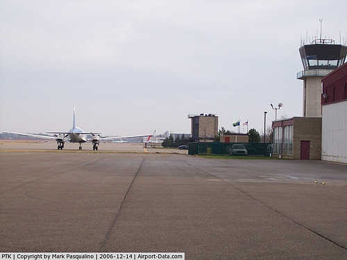
| Control Tower: | Yes |
| Lighting Schedule: | DUSK-DAWN
WHEN ATCT CLSD HIRL RY 09R/27L PRESET ON MED INTST; TO INCR INTST RDO REQ ON UNICOM. ACTVT MALSR RY 09R, PAPI RYS 09R & 35, & VASI RY 27L - CTAF. ACTVT REIL RYS 09L, 27R & 27L CTC TWR. |
| Beacon Color: | Clear-Green (lighted land airport) |
| Landing fee charge: | Yes
LNDG FEE FOR ACFT OVER 12500 LBS. |
| Sectional chart: | Detroit |
| Region: | AGL - Great Lakes |
| Boundary ARTCC: | ZOB - Cleveland |
| Tie-in FSS: | LAN - Lansing |
| FSS on Airport: | No |
| FSS Toll Free: | 1-800-WX-BRIEF |
| NOTAMs Facility: | PTK (NOTAM-d service avaliable) |
| Certification type/date: | IV A U 11/197
AIR CARRIER OPN WITH MORE THAN 30 PASSENGER SEATS RQR PPR CALL AMGR 248-666-3900. |
| Federal Agreements: | NGY |
Airport Communications
| CTAF: | 120.500 |
| Unicom: | 122.950 |
Airport Services
| Fuel available: | 100LLA |
| Airframe Repair: | MAJOR |
| Power Plant Repair: | MAJOR |
| Bottled Oxygen: | NONE |
| Bulk Oxygen: | HIGH |
Runway Information
Runway 09L/27R
| Dimension: | 5000 x 100 ft / 1524.0 x 30.5 m |
| Surface: | ASPH, Fair Condition |
| Surface Treatment: | Porous Friction Course |
| Weight Limit: | Single wheel: 38000 lbs.
Dual wheel: 60000 lbs.
Dual tandem wheel: 65000 lbs. |
| Edge Lights: | Medium |
| |
Runway 09L |
Runway 27R |
| Longitude: | 083-25-54.8105W | 083-24-47.9428W |
| Latitude: | 42-39-58.3176N | 42-40-00.3400N |
| Elevation: | 976.00 ft | 973.00 ft |
| Alignment: | 88 | 127 |
| Traffic Pattern: | Left | Left |
| Markings: | Basic, Fair Condition | Basic, Fair Condition |
| Runway End Identifier: | Yes | Yes |
| Centerline Lights: | No | No |
| Touchdown Lights: | No | No |
|
Runway 09R/27L
| Dimension: | 6200 x 150 ft / 1889.8 x 45.7 m |
| Surface: | ASPH, Fair Condition |
| Surface Treatment: | Porous Friction Course |
| Weight Limit: | Single wheel: 90000 lbs.
Dual wheel: 200000 lbs.
Dual tandem wheel: 280000 lbs. |
| Edge Lights: | High |
| |
Runway 09R |
Runway 27L |
| Longitude: | 083-25-59.2533W | 083-24-36.3433W |
| Latitude: | 42-39-52.7461N | 42-39-55.2509N |
| Elevation: | 980.00 ft | 972.00 ft |
| Alignment: | 88 | 127 |
| ILS Type: | ILS
| |
| Traffic Pattern: | Left | Left |
| Markings: | Precision instrument, Fair Condition | Precision instrument, Fair Condition |
| Crossing Height: | 0.00 ft | 45.00 ft |
| VASI: | 4-light PAPI on left side | 4-box on left side |
| Visual Glide Angle: | 3.00° | 3.00° |
| RVR Equipment: | touchdown | |
| Approach lights: | MALSR | |
| Runway End Identifier: | | Yes |
| Centerline Lights: | No | No |
| Touchdown Lights: | No | No |
| Obstruction: | , 50:1 slope to clear | 37 ft trees, 1383.0 ft from runway, 647 ft right of centerline, 31:1 slope to clear |
|
Runway 17/35
| Dimension: | 2585 x 75 ft / 787.9 x 22.9 m |
| Surface: | ASPH, Fair Condition |
| Surface Treatment: | Porous Friction Course |
| |
Runway 17 |
Runway 35 |
| Longitude: | 083-24-34.3689W | 083-24-29.3879W |
| Latitude: | 42-40-08.4834N | 42-39-43.2369N |
| Elevation: | 974.00 ft | 970.00 ft |
| Alignment: | 127 | 127 |
| Traffic Pattern: | Left | Left |
| VASI: | 2-light PAPI on left side
OTS INDEFLY. | 2-light PAPI on left side |
| Visual Glide Angle: | 3.00° | 3.00° |
| Runway End Identifier: | No | No |
| Centerline Lights: | No | No |
| Touchdown Lights: | No | No |
|
Radio Navigation Aids
| ID |
Type |
Name |
Ch |
Freq |
Var |
Dist |
| OZW | NDB | Howell | | 243.00 | 05W | 25.2 nm |
| VQ | NDB | Cargl | | 230.00 | 05W | 27.8 nm |
| G | NDB | Golf | | 398.00 | 05W | 30.2 nm |
| QG | NDB | Windsor | | 353.00 | 06W | 32.3 nm |
| RYS | NDB | Grosse Ile | | 419.00 | 06W | 35.9 nm |
| TCU | NDB | Tecumseh | | 239.00 | 04W | 43.0 nm |
| HYX | NDB | Browne | | 385.00 | 06W | 49.9 nm |
| MTC | TACAN | Selfridge | 064X | | 06W | 26.2 nm |
| DXO | VOR/DME | Detroit | 081X | 113.40 | 06W | 27.3 nm |
| YQG | VOR/DME | Windsor | 085X | 113.80 | 06W | 36.2 nm |
| PSI | VORTAC | Pontiac | 047X | 111.00 | 03W | 5.4 nm |
| SVM | VORTAC | Salem | 090X | 114.30 | 03W | 17.3 nm |
| FNT | VORTAC | Flint | 116X | 116.90 | 06W | 23.2 nm |
| CRL | VORTAC | Carleton | 104X | 115.70 | 03W | 37.2 nm |
| ECK | VORTAC | Peck | 087X | 114.00 | 07W | 47.0 nm |
| DET | VOT | Detroit City | | 111.60 | | 23.8 nm |
| YIP | VOT | Willow Run | | 112.00 | | 26.3 nm |
| DTW | VOT | Detroit Met Wayne | | 109.80 | | 26.4 nm |
Remarks
- ATCT UNABL TO SEE MORE THAN 200' SOUTH OF RY 35 THLD.
- BIRDS & DEER ON & INVOF ARPT.
- TWYS G & H UNLIGHTED NORTH OF RY 09R/27L.
- SEAPLANE LDGS & TAKEOFFS ON LAKE ANGELUS 4.5 MILES ENE IS PROHIBITED BY LOCAL ORDINANCES.
- U.S. CUSTOMS USER FEE ARPT. CONTACT U.S. CUSTOMS 0700-2000 MON-FRI ON 248-666-7717; OTHER TIMES MIN 3 HRS ADVANCE NOTIFICATION ON 734-942-9000.
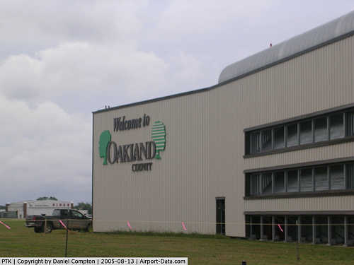
Images and information placed above are from
http://www.airport-data.com/airport/PTK/
We thank them for the data!
| General Info
|
| Country |
United States
|
| State |
MICHIGAN
|
| FAA ID |
PTK
|
| Latitude |
42-39-54.734N
|
| Longitude |
083-25-07.353W
|
| Elevation |
980 feet
|
| Near City |
PONTIAC
|
We don't guarantee the information is fresh and accurate. The data may
be wrong or outdated.
For more up-to-date information please refer to other sources.
|
|


