 |
|
| Nartron Field |
 |
| IATA: RCT – ICAO: KRCT – FAA LID: RCT |
| Summary |
| Airport type |
Public |
| Operator |
Norman Rautiola |
| Location |
Reed City, Michigan |
| Elevation AMSL |
1055 ft / 322 m |
| Coordinates |
43°54′00″N 85°31′00″W / 43.9°N 85.5166667°W / 43.9; -85.5166667Coordinates: 43°54′00″N 85°31′00″W / 43.9°N 85.5166667°W / 43.9; -85.5166667 |
| Runways |
| Direction |
Length |
Surface |
| ft |
m |
| 17/35 |
4,506 |
1373 |
Asphalt |
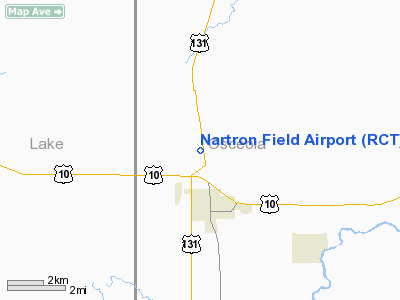
Nartron Field (IATA: RCT, ICAO: KRCT, FAA LID: RCT) is an airport located 2 miles (3.2 km) north of Reed City, Michigan, US. History
Originally known as Miller Airport, the facility was purchased by Nartron Corporation in the 1970's to house its engineering and manufacturing operations. These operations have since been moved to another location.
Facilities
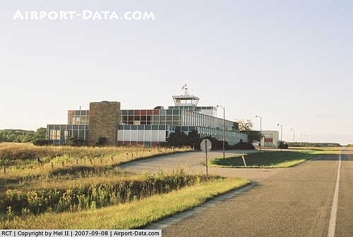
An abandoned terminal building, including a defunct control tower, sits on the southeast corner of the airport. It is locked and has nothing to offer to visiting aircraft.
An area east of runway 17/35 and north of the abandoned building is used by local RC model aircraft enthusiasts to fly model aircraft.
Runways
The only runway, 17/35, is in poor condition and the surface is cracked and scattered with stones. Vegetation grows through cracks.
An abandoned runway intersects runway 17/35. Its direction is approximately 8/26, it is roughly 2500 ft. long, and its surface is asphalt, in extremely poor condition.
Transit
The airport is accessible by road from Old US Highway 131, just north of the intersection of Old US Highway 131 and US 10. The airport is also adjacent to the freeway US 131, accessible from US 10.
The above content comes from Wikipedia and is published under free licenses – click here to read more.
|
 |
(Click on the photo to enlarge) |
Location & QuickFacts
| FAA Information Effective: | 2008-09-25 |
| Airport Identifier: | RCT |
| Airport Status: | Operational |
| Longitude/Latitude: | 085-31-00.1820W/43-54-00.0590N
-85.516717/43.900016 (Estimated) |
| Elevation: | 1055 ft / 321.56 m (Estimated) |
| Land: | 186 acres |
| From nearest city: | 2 nautical miles N of Reed City, MI |
| Location: | Osceola County, MI |
| Magnetic Variation: | 04W (1985) |
Owner & Manager
| Ownership: | Privately owned |
| Owner: | Norman Rautiola |
| Address: | 5000 North Us 131
Reed City, MI 49677 |
| Phone number: | 231-832-5513 |
| Manager: | Norman Rautiola
LOCAL CONTACT, ROBERT DAKIN, 231-832-5513, EXT. 214 |
| Address: | 5000 North Us 131
Reed City, MI 49677 |
| Phone number: | 231-832-5513 |
Airport Operations and Facilities
| Airport Use: | Open to public |
| Wind indicator: | Yes |
| Segmented Circle: | No |
| Control Tower: | No |
| Landing fee charge: | No |
| Sectional chart: | Chicago |
| Region: | AGL - Great Lakes |
| Boundary ARTCC: | ZMP - Minneapolis |
| Tie-in FSS: | LAN - Lansing |
| FSS on Airport: | No |
| FSS Toll Free: | 1-800-WX-BRIEF |
| NOTAMs Facility: | LAN (NOTAM-d service avaliable) |
Airport Communications
Airport Services
| Airframe Repair: | NONE |
| Power Plant Repair: | NONE |
| Bottled Oxygen: | NONE |
| Bulk Oxygen: | NONE |
Runway Information
Runway 17/35
| Dimension: | 4506 x 100 ft / 1373.4 x 30.5 m |
| Surface: | ASPH, Poor Condition
RY 17/35 SFC ROUGH; CRACKS IN RY; CONSIDERABLE AMT OF LOOSE STONES AND SAND ON PAVEMENT. |
| Weight Limit: | Single wheel: 11000 lbs. |
| |
Runway 17 |
Runway 35 |
| Longitude: | 085-31-03.7900W | 085-30-53.1000W |
| Latitude: | 43-54-22.1400N | 43-53-38.3200N |
| Elevation: | 1055.00 ft | 1055.00 ft |
| Traffic Pattern: | Left | Left |
| Markings: | Basic, Poor Condition
RY MARKINGS FADED. | Basic, Poor Condition |
| Centerline Lights: | No | No |
| Touchdown Lights: | No | No |
| Obstruction: | 30 ft trees, 201.0 ft from runway, 73 ft right of centerline
+10 FT TREES 25 FT R 0 FT DSTC FM RY END. | 44 ft tree, 1300.0 ft from runway, 90 ft right of centerline, 25:1 slope to clear
+50' BLDG 235' RIGHT OF CNTRLN EXTNDD. |
|
Radio Navigation Aids
| ID |
Type |
Name |
Ch |
Freq |
Var |
Dist |
| CAD | NDB | Cadillac | | 269.00 | 04W | 23.0 nm |
| LDM | NDB | Ludington | | 341.00 | 03W | 38.8 nm |
| GDW | NDB | Wiggins | | 209.00 | 04W | 45.3 nm |
| AMN | NDB | Alma | | 329.00 | 05W | 47.1 nm |
| HIC | VOR/DME | White Cloud | 123X | 117.60 | 01W | 21.4 nm |
| MOP | VOR/DME | Mount Pleasant | 043X | 110.60 | 05W | 37.7 nm |
| MBL | VOR/DME | Manistee | 051X | 111.40 | 05W | 38.9 nm |
| HTL | VOR/DME | Houghton Lake | 053X | 111.60 | 05W | 45.9 nm |
| TVC | VORTAC | Traverse City | 093X | 114.60 | 02W | 46.2 nm |
| MKG | VORTAC | Muskegon | 099X | 115.20 | 01W | 49.5 nm |
Remarks
- ARPT CLSD NOV THRU MAR & WHEN SNOW COVERED.
- TREES IN PRIMARY & TRANSITION SFCS RY 17/35, WEST SIDE.
- 26 FT BLDGS 195 FT EAST OF RWY 35, + 50 FT BLDG, 235 FT EAST OF EXTENDED CNTRLN, SOUTH END OF RWY.
- RADIO CONTROLLED MODEL ACFT OPERATIONS EAST OF RWY.
- EXISTED PRIOR TO 1959.
Images and information placed above are from
http://www.airport-data.com/airport/RCT/
We thank them for the data!
| General Info
|
| Country |
United States
|
| State |
MICHIGAN
|
| FAA ID |
RCT
|
| Latitude |
43-54-00.059N
|
| Longitude |
085-31-00.182W
|
| Elevation |
1055 feet
|
| Near City |
REED CITY
|
We don't guarantee the information is fresh and accurate. The data may
be wrong or outdated.
For more up-to-date information please refer to other sources.
|
|


