 |
|
Mount Pleasant Municipal Airport |
Coordinates: 43°37′18″N 084°44′15″W / 43.62167°N 84.7375°W / 43.62167; -84.7375
| Mount Pleasant Municipal Airport |
| IATA: MOP – ICAO: KMOP – FAA LID: MOP |
| Summary |
| Airport type |
Public |
| Owner |
City of Mt. Pleasant |
| Location |
Mount Pleasant, Michigan |
| Elevation AMSL |
755 ft / 230 m |
| Runways |
| Direction |
Length |
Surface |
| ft |
m |
| 9/27 |
5,000 |
1,524 |
Asphalt |
| 5/23 |
2,500 |
762 |
Turf |
| Statistics (2006) |
| Aircraft operations |
23,415 |
| Based aircraft |
30 |
| Source: Federal Aviation Administration |
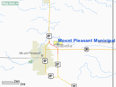
Mount Pleasant Municipal Airport (IATA: MOP, ICAO: KMOP, FAA LID: MOP) is a city-owned public-use airport located two miles (3 km) northeast of the central business district of Mount Pleasant, a city in Isabella County, Michigan, United States. The airport became active in 1940. It serves general aviation for Mount Pleasant and the surrounding area. There is no scheduled air service.
Facilities and aircraft
Mount Pleasant Municipal Airport covers an area of 344 acres (139 ha) which contains two runways:
- Runway 9/27: 5,000 x 100 ft (1,524 x 30 m), Surface: Asphalt
- Runway 5/23: 2,500 x 160 ft (762 x 49 m), Surface: Turf
For the 12-month period ending December 31, 2006, the airport had 23,415 aircraft operations, an average of 64 per day: 95% general aviation, 4% air taxi and <1% military. There are 30 aircraft based at this airport: 87% single-engine, 10% multi-engine and 3% ultralight.
The above content comes from Wikipedia and is published under free licenses – click here to read more.
Location & QuickFacts
| FAA Information Effective: | 2008-09-25 |
| Airport Identifier: | MOP |
| Airport Status: | Operational |
| Longitude/Latitude: | 084-44-14.9460W/43-37-18.0060N
-84.737485/43.621668 (Estimated) |
| Elevation: | 755 ft / 230.12 m (Surveyed) |
| Land: | 344 acres |
| From nearest city: | 2 nautical miles NE of Mount Pleasant, MI |
| Location: | Isabella County, MI |
| Magnetic Variation: | 05W (1995) |
Owner & Manager
| Ownership: | Publicly owned |
| Owner: | City Of Mt. Pleasant |
| Address: | 401 N Main Street, 1303 N. Franklin
Mount Pleasant, MI 48858 |
| Phone number: | 989-779-5402 |
| Manager: | John D. Benzinger |
| Address: | 5453 East Airport Rd
Mount Pleasant, MI 48858 |
| Phone number: | 989-772-2965 |
Airport Operations and Facilities
| Airport Use: | Open to public |
| Wind indicator: | Yes |
| Segmented Circle: | Yes |
| Control Tower: | No |
| Lighting Schedule: | DUSK-DAWN
ACTVT MIRL RY 09/27 & REIL & PAPI RY 27 - CTAF. |
| Beacon Color: | Clear-Green (lighted land airport) |
| Landing fee charge: | No |
| Sectional chart: | Detroit |
| Region: | AGL - Great Lakes |
| Boundary ARTCC: | ZMP - Minneapolis |
| Responsible ARTCC: | ZOB - Cleveland |
| Tie-in FSS: | LAN - Lansing |
| FSS on Airport: | No |
| FSS Toll Free: | 1-800-WX-BRIEF |
| NOTAMs Facility: | MOP (NOTAM-d service avaliable) |
| Federal Agreements: | NGY |
Airport Communications
| CTAF: | 123.000 |
| Unicom: | 123.000 |
Airport Services
| Fuel available: | 100LLA |
| Airframe Repair: | MAJOR |
| Power Plant Repair: | MAJOR |
| Bottled Oxygen: | NONE |
| Bulk Oxygen: | NONE |
Runway Information
Runway 05/23
| Dimension: | 2500 x 160 ft / 762.0 x 48.8 m |
| Surface: | TURF, Fair Condition |
| |
Runway 05 |
Runway 23 |
| Longitude: | 084-44-48.0470W | 084-44-19.4510W |
| Latitude: | 43-37-13.1060N | 43-37-26.4500N |
| Alignment: | 57 | 127 |
| Traffic Pattern: | Left | Left |
| Runway End Identifier: | No | No |
| Centerline Lights: | No | No |
| Touchdown Lights: | No | No |
| Obstruction: | 57 ft tree, 742.0 ft from runway, 135 ft left of centerline, 13:1 slope to clear | 73 ft trees, 1460.0 ft from runway, 20:1 slope to clear |
|
Runway 09/27
| Dimension: | 5000 x 100 ft / 1524.0 x 30.5 m |
| Surface: | ASPH, Good Condition |
| Weight Limit: | Single wheel: 50000 lbs.
Dual wheel: 65000 lbs.
Dual tandem wheel: 118000 lbs. |
| Edge Lights: | Medium |
| |
Runway 09 |
Runway 27 |
| Longitude: | 084-44-39.5390W | 084-43-31.5730W |
| Latitude: | 43-37-17.5270N | 43-37-16.6970N |
| Elevation: | 754.00 ft | 752.00 ft |
| Alignment: | 91 | 127 |
| Traffic Pattern: | Left | Left |
| Markings: | Non-precision instrument, Fair Condition | Non-precision instrument, Fair Condition |
| Crossing Height: | 0.00 ft | 36.00 ft |
| VASI: | | 4-light PAPI on left side |
| Visual Glide Angle: | 0.00° | 3.00° |
| Runway End Identifier: | | Yes |
| Centerline Lights: | No | No |
| Touchdown Lights: | No | No |
| Obstruction: | 107 ft trees, 2340.0 ft from runway, 20:1 slope to clear | , 50:1 slope to clear |
|
Radio Navigation Aids
| ID |
Type |
Name |
Ch |
Freq |
Var |
Dist |
| AMN | NDB | Alma | | 329.00 | 05W | 18.1 nm |
| GDW | NDB | Wiggins | | 209.00 | 04W | 23.8 nm |
| HYX | NDB | Browne | | 385.00 | 06W | 40.0 nm |
| BHW | NDB | Hardwood | | 236.00 | 06W | 47.1 nm |
| CAD | NDB | Cadillac | | 269.00 | 04W | 49.0 nm |
| MBS | VOR/DME | Saginaw | 076X | 112.90 | 03W | 29.3 nm |
| HIC | VOR/DME | White Cloud | 123X | 117.60 | 01W | 42.7 nm |
| BXZ | VOR/DME | West Branch | 079X | 113.20 | 06W | 44.4 nm |
| HTL | VOR/DME | Houghton Lake | 053X | 111.60 | 05W | 44.4 nm |
Remarks
- DEER & BIRDS ON & INVOF ARPT.
- RY 27 NOISE ABATEMENT: CLIMB TO 1500 FT AGL BEFORE TURNING OVER CITY.
Images and information placed above are from
http://www.airport-data.com/airport/MOP/
We thank them for the data!
| General Info
|
| Country |
United States
|
| State |
MICHIGAN
|
| FAA ID |
MOP
|
| Latitude |
43-37-18.006N
|
| Longitude |
084-44-14.946W
|
| Elevation |
755 feet
|
| Near City |
MOUNT PLEASANT
|
We don't guarantee the information is fresh and accurate. The data may
be wrong or outdated.
For more up-to-date information please refer to other sources.
|
|


