 |
|
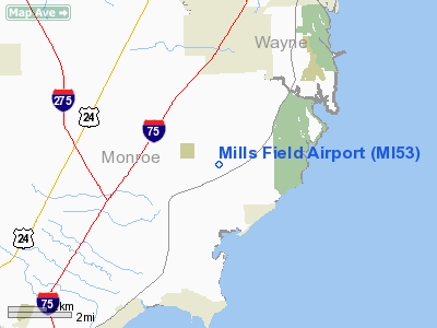
Location & QuickFacts
| FAA Information Effective: | 2008-09-25 |
| Airport Identifier: | MI53 |
| Airport Status: | Operational |
| Longitude/Latitude: | 083-15-29.7460W/42-00-33.1610N
-83.258263/42.009211 (Estimated) |
| Elevation: | 590 ft / 179.83 m (Estimated) |
| Land: | 20 acres |
| From nearest city: | 4 nautical miles E of Newport, MI |
| Location: | Monroe County, MI |
| Magnetic Variation: | 05W (1985) |
Owner & Manager
| Ownership: | Privately owned |
| Owner: | Robert D Mills |
| Address: | 9100 N Dixie Hwy
Newport, MI 48166 |
| Phone number: | 313-586-3309 |
| Manager: | Robert D Mills |
| Address: | 9100 N Dixie Hwy
Newport, MI 48166 |
| Phone number: | 313-586-3309 |
Airport Operations and Facilities
| Airport Use: | Private
PERSONAL. |
| Wind indicator: | Yes |
| Segmented Circle: | No |
| Control Tower: | No |
| Sectional chart: | Detroit |
| Region: | AGL - Great Lakes |
| Boundary ARTCC: | ZOB - Cleveland |
| Tie-in FSS: | LAN - Lansing |
| FSS Toll Free: | 1-800-WX-BRIEF |
Airport Services
| Airframe Repair: | MINOR |
| Power Plant Repair: | MINOR |
Runway Information
Runway 09/27
| Dimension: | 2400 x 65 ft / 731.5 x 19.8 m |
| Surface: | TURF, Good Condition |
| |
Runway 09 |
Runway 27 |
| Traffic Pattern: | Left | Left |
| Displaced threshold: | 500.00 ft | 210.00 ft |
| Obstruction: | 30 ft pline, 100.0 ft from runway, 3:1 slope to clear
APCH RATIO 20:1 AT DSPLCD THLD DUE TO 30 FT PLINE 600 FT FM DSPLCD THLD. | 10 ft tree, 47.0 ft from runway, 40 ft left of centerline, 4:1 slope to clear
APCH RATIO 13:1 AT DSPLCD THLD DUE TO 30 FT PLINE 411 FT FM DSPLCD THLD. |
|
Radio Navigation Aids
| ID |
Type |
Name |
Ch |
Freq |
Var |
Dist |
| RYS | NDB | Grosse Ile | | 419.00 | 06W | 7.3 nm |
| G | NDB | Golf | | 398.00 | 05W | 17.0 nm |
| VQ | NDB | Cargl | | 230.00 | 05W | 24.9 nm |
| QG | NDB | Windsor | | 353.00 | 06W | 25.2 nm |
| TCU | NDB | Tecumseh | | 239.00 | 04W | 27.8 nm |
| PT | NDB | Pelee Island | | 283.00 | 05W | 29.7 nm |
| PCW | NDB | Port Clinton | | 423.00 | 06W | 34.3 nm |
| ADG | NDB | Adrian | | 278.00 | 06W | 37.6 nm |
| USE | NDB | Fulton | | 375.00 | 05W | 46.0 nm |
| OZW | NDB | Howell | | 243.00 | 05W | 49.6 nm |
| FZI | NDB | Fostoria | | 379.00 | 05W | 49.7 nm |
| TOL | TACAN | Toledo | 072X | | 05W | 34.8 nm |
| MTC | TACAN | Selfridge | 064X | | 06W | 40.9 nm |
| DXO | VOR/DME | Detroit | 081X | 113.40 | 06W | 13.2 nm |
| YQG | VOR/DME | Windsor | 085X | 113.80 | 06W | 24.0 nm |
| VWV | VOR/DME | Waterville | 078X | 113.10 | 02W | 37.6 nm |
| SKY | VOR/DME | Sandusky | 029X | 109.20 | 04W | 43.9 nm |
| CRL | VORTAC | Carleton | 104X | 115.70 | 03W | 9.2 nm |
| SVM | VORTAC | Salem | 090X | 114.30 | 03W | 28.3 nm |
| PSI | VORTAC | Pontiac | 047X | 111.00 | 03W | 43.3 nm |
| DTW | VOT | Detroit Met Wayne | | 109.80 | | 14.0 nm |
| YIP | VOT | Willow Run | | 112.00 | | 17.9 nm |
| DET | VOT | Detroit City | | 111.60 | | 26.1 nm |
Remarks
- PRVDD THE AREA 125 FT EITHER SIDE OF RY CNTRLN & 200 FT OFF RY END BE CLEAR; ANY OBSTN IN APCH IS REMOVED OR LOWERED OR THLD DSPLCD TO PRVD A CLEAR 20:1.
Images and information placed above are from
http://www.airport-data.com/airport/MI53/
We thank them for the data!
| General Info
|
| Country |
United States
|
| State |
MICHIGAN
|
| FAA ID |
MI53
|
| Latitude |
42-00-33.161N
|
| Longitude |
083-15-29.746W
|
| Elevation |
590 feet
|
| Near City |
NEWPORT
|
We don't guarantee the information is fresh and accurate. The data may
be wrong or outdated.
For more up-to-date information please refer to other sources.
|
|


