 |
|
Location & QuickFacts
| FAA Information Effective: | 2008-09-25 |
| Airport Identifier: | 27C |
| Airport Status: | Operational |
| Longitude/Latitude: | 085-15-45.1290W/43-37-45.0970N
-85.262536/43.629194 (Estimated) |
| Elevation: | 1022 ft / 311.51 m (Estimated) |
| Land: | 12 acres |
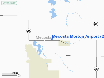
| From nearest city: | 2 nautical miles W of Mecosta, MI |
| Location: | Mecosta County, MI |
| Magnetic Variation: | 04W (1985) |
Owner & Manager
| Ownership: | Publicly owned |
| Owner: | Village Of Mecosta |
| Address: | 115 W. Main St
Mecosta, MI 49332 |
| Phone number: | 231-972-7116 |
| Manager: | Tom Shortsle |
| Address: | 11087 75 Th Ave
Mecosta, MI 49332 |
| Phone number: | 231-250-5441 |
Airport Operations and Facilities
| Airport Use: | Open to public |
| Wind indicator: | Yes |
| Segmented Circle: | Yes |
| Control Tower: | No |
| Landing fee charge: | No |
| Sectional chart: | Chicago |
| Region: | AGL - Great Lakes |
| Boundary ARTCC: | ZMP - Minneapolis |
| Tie-in FSS: | LAN - Lansing |
| FSS on Airport: | No |
| FSS Toll Free: | 1-800-WX-BRIEF |
| NOTAMs Facility: | LAN (NOTAM-d service avaliable) |
Airport Communications
Airport Services
| Airframe Repair: | NONE |
| Power Plant Repair: | NONE |
| Bottled Oxygen: | NONE |
| Bulk Oxygen: | NONE |
Runway Information
Runway 03/21
| Dimension: | 2010 x 100 ft / 612.6 x 30.5 m |
| Surface: | TURF, Poor Condition
SFC ROUGH
SFC ROUGH. |
| |
Runway 03 |
Runway 21 |
| Longitude: | 085-15-54.9200W | 085-15-43.8300W |
| Latitude: | 43-37-36.3700N | 43-37-48.0900N |
| Elevation: | 1022.00 ft | 1022.00 ft |
| Traffic Pattern: | Left | Left |
| Displaced threshold: | 760.00 ft | 460.00 ft |
| Obstruction: | 51 ft trees, 357.0 ft from runway, 108 ft left of centerline, 7:1 slope to clear
APCH RATIO 20:1 AT DSPLCD THR OVR 90 FT TREE; 1800 FT FM DSPLCD THR. | 34 ft trees, 0.0 ft from runway, 125 ft right of centerline
APCH RATIO 7:1 AT DSPLCD THLD OVER 38 FT TREES, 266 FT FM DSPLCD THLD, 125 FT L. |
|
Runway 09/27
| Dimension: | 2027 x 100 ft / 617.8 x 30.5 m |
| Surface: | TURF, Poor Condition
SFC ROUGH
SFC ROUGH. |
| |
Runway 09 |
Runway 27 |
| Longitude: | 085-15-55.3500W | 085-15-27.5700W |
| Latitude: | 43-37-47.7900N | 43-37-47.7900N |
| Elevation: | 1022.00 ft | 1022.00 ft |
| Traffic Pattern: | Left | Left |
| Markings: | None,
09/27 & DSPLCD THLDS MKD WITH 18 INCH YELLOW CONES. | None, |
| Displaced threshold: | 546.00 ft | 0.00 ft |
| Runway End Identifier: | No | No |
| Centerline Lights: | No | No |
| Touchdown Lights: | No | No |
| Obstruction: | 14 ft road, 38.0 ft from runway, 2:1 slope to clear
APCH RATIO 20:1 AT DSPLCD THLD THLD OVR +36 FT TREES, 720 FT FM DSPLCD THLD. | 20 ft brdg, 80.0 ft from runway, 125 ft left of centerline, 4:1 slope to clear |
|
Radio Navigation Aids
| ID |
Type |
Name |
Ch |
Freq |
Var |
Dist |
| AMN | NDB | Alma | | 329.00 | 05W | 27.8 nm |
| CAD | NDB | Cadillac | | 269.00 | 04W | 39.4 nm |
| GDW | NDB | Wiggins | | 209.00 | 04W | 39.8 nm |
| HIC | VOR/DME | White Cloud | 123X | 117.60 | 01W | 20.0 nm |
| MOP | VOR/DME | Mount Pleasant | 043X | 110.60 | 05W | 22.9 nm |
| MKG | VORTAC | Muskegon | 099X | 115.20 | 01W | 43.8 nm |
Remarks
- NO SNOW REMOVAL.
- MODEL AIRCRAFT AREA EAST OF RY 03/21 INTERSECTION.
- VFR WX CONDS;RWY 3 THR DSPLCD TO PROVIDE 20:1 TO CLR TV TWR & PLINE SW OF APT,RWY 9 THR DSPLCD TO PROVIDE 20:1 TO CLR RD W OF APT; CONTD..THAT TREES NEAR RWY 3-21 INT BE CLRD;THAT TREES S OF THE E END OF RWY 9-27 BE CLRD TO PROVIDE A 7:1 BEGNG FM THE S EDGE OF PRIM SFC.
Images and information placed above are from
http://www.airport-data.com/airport/27C/
We thank them for the data!
| General Info
|
| Country |
United States
|
| State |
MICHIGAN
|
| FAA ID |
27C
|
| Latitude |
43-37-45.097N
|
| Longitude |
085-15-45.129W
|
| Elevation |
1022 feet
|
| Near City |
MECOSTA
|
We don't guarantee the information is fresh and accurate. The data may
be wrong or outdated.
For more up-to-date information please refer to other sources.
|
|


