|
 |
|
||||
|
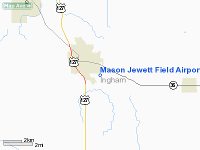
Mason Jewett Field (ICAO: KTEW, FAA LID: TEW) is a public use airport located one nautical mile (1.85 km) southeast of the central business district of Mason, in Ingham County, Michigan, United States. It is owned and operated by the Capital Region Airport Authority, which also oversees the nearby Capital Region International Airport (LAN) in Lansing, Michigan. According to the FAA's National Plan of Integrated Airport Systems for 2009–2013, it is categorized as a general aviation airport. Although many U.S. airports use the same three-letter location identifier for the FAA and IATA, this airport is assigned TEW by the FAA and no designation from the IATA. History1940s-1960sMason mayor, Arthur W. Jewett, believed that the popularity of aviation during World War II, and the return of veterans to the area would make an airport an increasingly important asset to the community. Further, the airport could promote industrial development around Mason. On December 16, 1943, Arthur Jewett purchased the 180 acres (73 ha) Elsworth Farm southeast of Mason. In early 1944 runway 9/27 was constructed at 2,800 feet (853 m) with a turf surface. An existing hip roof barn at the west end of the airfield was converted in to an airplane hangar capable of holding three or four planes. A hangar with room for six planes, was built at the northwest end of the airport. A Civil Air Patrol Squadron plane from Lansing was the first to land on the new runway. In October 1944 Stanley Keck became the first operator of the new Jewett Flying School. A 2,500 feet (762 m) north-south runway was completed at the east end of the existing runway. An increase of privately-owned aircraft based at the airport prompted the construction of five t-hangars along Eden Road in mid-1946. The Sycamore Valley Flyers flying club operated at the airport from 1946 to 1966. In 1948 Laylin Jewett established an aircraft maintenance facility at Jewett Field. In fall 1949 lights were installed on runway 9/27. A model airplane hobby shop opened at the airport in the winter of 1949. By 1950 there were more than 30 planes based at the airport. In September 1950 the airport owner, Arthur Jewett, decided to close the airport. By the mid-1950s the airport reopened with Bartlett Smith as Assistant Airport Manager. Harold Manville operated a flight training and aircraft rental business at the airport from 1968 to 1974. 1970s to present
In October 1973 a two-year disagreement over a lease on the airport was settled between Arthur Jewett, and the airport's operator, Harold Manville. In November, the Michigan Aeronautics Commission granted a license to Arthur Jewett, allowing the facility to remain in operation. In March 1977 the Capital Region Airport Authority purchased the 180 acres (73 ha) of airport property from Arthur Jewett as a reliever airfield for Capital City Airport (now Capital Region International Airport) in Lansing. The existing buildings at the airport were removed and a new 3,000 feet (914 m) asphalt runway 9/27 was constructed. The north-south runway was decommissioned and a new terminal was built on its location. During the next decade, the Capital Region Airport Authority purchased approximately 100 acres (40 ha) of adjoining property, allowing the runway to be lengthened to 4,000 feet (1,220 m). A lighted parallel taxiway was also constructed. The Experimental Aircraft Association, Chapter 55, moved to Jewett Field in 1984. The Association built the airport's Chapter Hangar in 1985, which provides space for members' aircraft, a workshop, and a meeting room. In 1998 Jewett Field operator, AeroGenesis Aviation, built a maintenance hanger and office building at the airport. In June 2009 Lansing Community College signed a 5-year lease for a building at Jewett Field to house the college's aviation mechanics program. The program is based out of nearby Capital Region International Airport, with potential displacement due to that airport's expansion plans. By February 2010 the June 2009 lease was under litigation. Aviation DaysAviation Days is an annual event at Jewett Field that showcases vintage aircraft, including homemade planes, antique passenger planes, and World War II-era military aircraft. The event is organized by the Experimental Aircraft Association, Chapter 55, in Mason. Facilities and aircraftMason Jewett Field covers an area of 275 acres (111 ha) at an elevation of 920 feet (280 m) above mean sea level. It has one runway designated 10/28 with an asphalt surface measuring 4,000 by 75 feet (1,219 x 23 m). The airport is staffed Monday through Friday from 7AM until 4PM. Currently Jewett Field has hangar space for more than 80 airplanes. For the 12-month period ending December 31, 2008, the airport had 20,960 general aviation aircraft operations, an average of 57 per day. At that time there were 64 aircraft based at this airport: 86% single-engine, 8% multi-engine, 3% jet and 3% ultralight. Transit
Incidents and AccidentsOn September 17, 2010, a Tecnam P2004 Bravo single-engine plane lost power and crashed in a field north of the airport shortly after takeoff, crushing to nose of the plane. The pilot was hospitalized. Photo galleryThe above content comes from Wikipedia and is published under free licenses – click here to read more.
Location & QuickFacts
Owner & Manager
Airport Operations and Facilities
Airport Communications
Airport Services
Runway InformationRunway 10/28
Radio Navigation Aids
Remarks
Images and information placed above are from We thank them for the data!
We don't guarantee the information is fresh and accurate. The data may
be wrong or outdated.
|
|||||||||||||||||||||||||||||||||||||||||||||||||||||||||||||||||||||||||||||||||||||||||||||||||||||||||||||||||||||||||||||||||||||||||||||||||||||||||||||||||||||||||||||||||||||||||||||||||||||||||||||||||||||||||||||||||||||||||||||||||||||||||||||||||||||||||||||||||||||||||||||||||||||||||||||||||||||||||||||||||||||||||||||||||||||||||||||||||||||

 |
|
Copyright 2004-2024 © by Airports-Worldwide.com, Vyshenskoho st. 36, Lviv 79010, Ukraine Legal Disclaimer |