 |
|
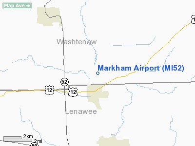
Location & QuickFacts
| FAA Information Effective: | 2008-09-25 |
| Airport Identifier: | MI52 |
| Airport Status: | Operational |
| Longitude/Latitude: | 083-58-04.7950W/42-05-26.1500N
-83.967999/42.090597 (Estimated) |
| Elevation: | 825 ft / 251.46 m (Estimated) |
| Land: | 85 acres |
| From nearest city: | 2 nautical miles S of Clinton, MI |
| Location: | Washtenaw County, MI |
| Magnetic Variation: | 04W (1985) |
Owner & Manager
| Ownership: | Privately owned |
| Owner: | Ron & Mariann Markham |
| Address: | 13073 Clinton Rd
Clinton, MI 49236-9629 |
| Phone number: | 517-456-4908 |
| Manager: | Ron & Mariann Markham |
| Address: | 13073 Clinton Rd
Clinton, MI 49236-9629 |
| Phone number: | 517-456-4908 |
Airport Operations and Facilities
| Airport Use: | Private |
| Segmented Circle: | No |
| Control Tower: | No |
| Sectional chart: | Detroit |
| Region: | AGL - Great Lakes |
| Boundary ARTCC: | ZOB - Cleveland |
| Tie-in FSS: | LAN - Lansing |
| FSS on Airport: | No |
| FSS Toll Free: | 1-800-WX-BRIEF |
Runway Information
Runway 09/27
| Dimension: | 2200 x 65 ft / 670.6 x 19.8 m |
| Surface: | TURF, |
| |
Runway 09 |
Runway 27 |
| Traffic Pattern: | Left | Right |
| Obstruction: | 25 ft pline | |
|
Radio Navigation Aids
| ID |
Type |
Name |
Ch |
Freq |
Var |
Dist |
| TCU | NDB | Tecumseh | | 239.00 | 04W | 5.1 nm |
| ADG | NDB | Adrian | | 278.00 | 06W | 14.1 nm |
| USE | NDB | Fulton | | 375.00 | 05W | 29.9 nm |
| OZW | NDB | Howell | | 243.00 | 05W | 32.7 nm |
| RYS | NDB | Grosse Ile | | 419.00 | 06W | 36.4 nm |
| G | NDB | Golf | | 398.00 | 05W | 42.0 nm |
| BYN | NDB | Bryan | | 260.00 | 04W | 43.0 nm |
| VQ | NDB | Cargl | | 230.00 | 05W | 47.9 nm |
| DFI | NDB | Defiance | | 246.00 | 05W | 49.9 nm |
| TOL | TACAN | Toledo | 072X | | 05W | 30.8 nm |
| JXN | VOR/DME | Jackson | 033X | 109.60 | 05W | 24.1 nm |
| DXO | VOR/DME | Detroit | 081X | 113.40 | 06W | 27.8 nm |
| LFD | VOR/DME | Litchfield | 049X | 111.20 | 05W | 35.6 nm |
| VWV | VOR/DME | Waterville | 078X | 113.10 | 02W | 41.2 nm |
| CRL | VORTAC | Carleton | 104X | 115.70 | 03W | 22.9 nm |
| SVM | VORTAC | Salem | 090X | 114.30 | 03W | 25.3 nm |
| PSI | VORTAC | Pontiac | 047X | 111.00 | 03W | 41.5 nm |
| LAN | VORTAC | Lansing | 045X | 110.80 | 05W | 49.7 nm |
| YIP | VOT | Willow Run | | 112.00 | | 21.6 nm |
| DTW | VOT | Detroit Met Wayne | | 109.80 | | 28.1 nm |
| DET | VOT | Detroit City | | 111.60 | | 46.4 nm |
Remarks
- OWNER DESIRES ARPT NOT BE CHARTED.
- PROVIDED OBSTRUCTIONS IN APCH AREA ARE REMOVED/LOWERED TO PROVIDE 20:1 CLNC SLOPE; AREA 125' EITHER SIDE OF CNTRLN IS CLEAR; OPERATIONS ARE TO THE NORTH OF RY.
Images and information placed above are from
http://www.airport-data.com/airport/MI52/
We thank them for the data!
| General Info
|
| Country |
United States
|
| State |
MICHIGAN
|
| FAA ID |
MI52
|
| Latitude |
42-05-26.150N
|
| Longitude |
083-58-04.795W
|
| Elevation |
825 feet
|
| Near City |
CLINTON
|
We don't guarantee the information is fresh and accurate. The data may
be wrong or outdated.
For more up-to-date information please refer to other sources.
|
|


