 |
|
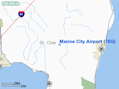
Location & QuickFacts
| FAA Information Effective: | 2008-09-25 |
| Airport Identifier: | 76G |
| Airport Status: | Operational |
| Longitude/Latitude: | 082-35-44.6890W/42-43-15.1170N
-82.595747/42.720866 (Estimated) |
| Elevation: | 613 ft / 186.84 m (Estimated) |
| Land: | 70 acres |
| From nearest city: | 4 nautical miles W of Marine City, MI |
| Location: | St Clair County, MI |
| Magnetic Variation: | 06W (1985) |
Owner & Manager
| Ownership: | Privately owned |
| Owner: | Willis Manter |
| Address: | 7115 Marine City Hwy
Marine City, MI 48039 |
| Phone number: | 810-765-8289 |
| Manager: | Willis Bill Manter |
| Address: | 7115 Marine City Hwy
Marine City, MI 48039 |
| Phone number: | 810-765-8289 |
Airport Operations and Facilities
| Airport Use: | Open to public |
| Wind indicator: | Yes |
| Segmented Circle: | Yes |
| Control Tower: | No |
| Lighting Schedule: | DUSK-DAWN |
| Beacon Color: | Clear-Green (lighted land airport) |
| Sectional chart: | Detroit |
| Region: | AGL - Great Lakes |
| Boundary ARTCC: | ZOB - Cleveland |
| Tie-in FSS: | LAN - Lansing |
| FSS Toll Free: | 1-800-WX-BRIEF |
| NOTAMs Facility: | LAN (NOTAM-d service avaliable) |
| Federal Agreements: | N |
Airport Communications
| CTAF: | 123.000 |
| Unicom: | 123.000 |
Airport Services
| Fuel available: | 100LLA |
| Airframe Repair: | MAJOR |
| Power Plant Repair: | MAJOR |
Runway Information
Runway 04/22
| Dimension: | 3100 x 60 ft / 944.9 x 18.3 m |
| Surface: | ASPH, Fair Condition |
| Edge Lights: | Non-standard lighting system
NSTD MIRL LOCATED 23 FT FM RY EDGE. |
| |
Runway 04 |
Runway 22 |
| Longitude: | 082-35-53.3200W | 082-35-36.0300W |
| Latitude: | 42-43-06.0000N | 42-43-24.2100N |
| Elevation: | 613.00 ft | 613.00 ft |
| Traffic Pattern: | Left | Left |
| Markings: | Basic, Fair Condition | Basic, Fair Condition |
| Crossing Height: | 25.00 ft | 25.00 ft |
| Displaced threshold: | 0.00 ft | 295.00 ft |
| VASI: | 2-light PAPI on left side | 2-light PAPI on left side |
| Visual Glide Angle: | 4.00° | 4.00° |
| Runway End Identifier: | Yes | |
| Obstruction: | 100 ft pline, 2000.0 ft from runway, 18:1 slope to clear | 6 ft brush, 201.0 ft from runway
APCH RATIO 20:1 TO DSPLCD THR; +15' ROAD 300' 125'R.
RY 22 HAS +15' ROAD AT THLD 125' R; +15' BRUSH/TREES 186' FROM THLD, +15 FT ROAD 130 FT L. |
|
Radio Navigation Aids
| ID |
Type |
Name |
Ch |
Freq |
Var |
Dist |
| ZR | NDB | Sarnia | | 404.00 | 06W | 20.7 nm |
| VQ | NDB | Cargl | | 230.00 | 05W | 27.1 nm |
| QG | NDB | Windsor | | 353.00 | 06W | 27.3 nm |
| 4L | NDB | Chatham | | 236.00 | 06W | 33.6 nm |
| G | NDB | Golf | | 398.00 | 05W | 35.0 nm |
| RYS | NDB | Grosse Ile | | 419.00 | 06W | 44.7 nm |
| MTC | TACAN | Selfridge | 064X | | 06W | 12.3 nm |
| YQG | VOR/DME | Windsor | 085X | 113.80 | 06W | 30.1 nm |
| DXO | VOR/DME | Detroit | 081X | 113.40 | 06W | 45.8 nm |
| ECK | VORTAC | Peck | 087X | 114.00 | 07W | 32.6 nm |
| PSI | VORTAC | Pontiac | 047X | 111.00 | 03W | 41.4 nm |
| SVM | VORTAC | Salem | 090X | 114.30 | 03W | 48.0 nm |
| DET | VOT | Detroit City | | 111.60 | | 26.6 nm |
| DTW | VOT | Detroit Met Wayne | | 109.80 | | 45.2 nm |
Images and information placed above are from
http://www.airport-data.com/airport/76G/
We thank them for the data!
| General Info
|
| Country |
United States
|
| State |
MICHIGAN
|
| FAA ID |
76G
|
| Latitude |
42-43-15.117N
|
| Longitude |
082-35-44.689W
|
| Elevation |
613 feet
|
| Near City |
MARINE CITY
|
We don't guarantee the information is fresh and accurate. The data may
be wrong or outdated.
For more up-to-date information please refer to other sources.
|
|


