 |
|
| Mackinac Island Airport |
 |
| IATA: MCD – ICAO: KMCD – FAA LID: MCD |
| Summary |
| Airport type |
Public |
| Operator |
Mackinac Island State Park Commission |
| Location |
Mackinac Island, Michigan |
| Elevation AMSL |
740 ft / 225.6 m |
| Coordinates |
45°51′53.764″N 84°38′14.440″W / 45.86493444°N 84.6373444°W / 45.86493444; -84.6373444Coordinates: 45°51′53.764″N 84°38′14.440″W / 45.86493444°N 84.6373444°W / 45.86493444; -84.6373444 |
| Runways |
| Direction |
Length |
Surface |
| ft |
m |
| 8/26 |
3,501 |
1,067 |
Asphalt |
|
| Mackinac Island Airport |
U.S. National Historic Landmark District
Contributing Property |
| Added to NRHP: |
October 9, 1960 |
| Part of: |
Mackinac Island (#66000397) |
|
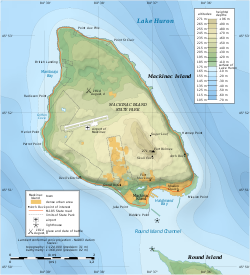
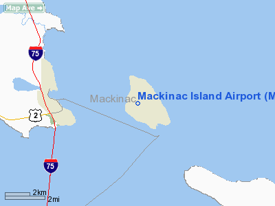
Mackinac Island Airport (IATA: MCD, ICAO: KMCD, FAA LID: MCD) is a public airport located 1 mile (2 km) northwest of the city of Mackinac Island in Mackinac County, Michigan, USA. It is located in the center of Mackinac Island. History
Mackinac Island Airport was activated in 1940. Today it is in use by tourists with 81% transient general aviation and 18% air taxi. The <1% remainder being the general aviation by the local population.
Airline
- Great Lakes Air - Charter service from Pellston Regional Airport and Mackinac County Airport in St. Ignace.
Facilities
- The airport is staffed September through May from 7:30AM until 5:30PM, and June through August from 8AM until 5PM.
- There is no fuel available at Mackinac Island Airport. The closest FBOs with fuel are in St. Ignace, Cheboygan and Pellston.
- No camping is allowed on Mackinac Island, but nearby Bois Blanc island has an airstrip and allows camping at the field.
- Pilot Controlled Lighting is on 122.8, UNICOM is on 122.7
Runways
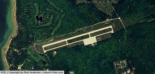
- Runway 8/26: 3,501 x 75 ft. (1,067 x 23 m), Surface: Asphalt
Transit
- The airport is accessible by road from Annex Road, and is close to (but not directly accessible from) M-185. One special note is that no motorized vehicles, with the exception of emergency vehicles, and snowmobiles in winter, are allowed on Mackinac Island. Travel on the island is accomplished on foot, horse, horse-drawn vehicle, or bicycle.
- There are no bicycle rentals available at the airport, but some private bikes can be stored in the racks outside.
- The airport UNICOM operator can usually be reached during normal business hours on the UNICOM frequency 122.7. The UNICOM operator can call a horse drawn taxi for you.
- The airport is about a 20 minute walk from the downtown area. The quickest route to downtown is to turn left from Airport Road onto Annex Road to the next major intersection and turn right on Cadotte Avenue (formerly known as, and still sometimes posted as, Hoban Road). Cadotte Ave. runs through the residential area known as Harrisonville and eventually leads to downtown.
- The Stonecliffe resort and Woods Restaurant are immediately off the west end of the runway. There is a gate in the fence which leads directly to the Stonecliffe grounds.
 | |
Map shows airport in interior of Mackinac Island, with runway oriented east-west |
The above content comes from Wikipedia and is published under free licenses – click here to read more.
|
 |
(Click on the photo to enlarge) |
Location & QuickFacts
| FAA Information Effective: | 2008-09-25 |
| Airport Identifier: | MCD |
| Airport Status: | Operational |
| Longitude/Latitude: | 084-38-14.4400W/45-51-53.7640N
-84.637344/45.864934 (Estimated) |
| Elevation: | 740 ft / 225.55 m (Surveyed) |
| Land: | 125 acres |
| From nearest city: | 1 nautical miles NW of Mackinac Island, MI |
| Location: | Mackinac County, MI |
| Magnetic Variation: | 07W (2000) |
Owner & Manager
| Ownership: | Publicly owned |
| Owner: | Mackinac Island State Park Comm. |
| Address: | Box 370
Mackinac Island, MI 49757 |
| Phone number: | 906-847-3231 |
| Manager: | Dan Cook
ASST MGR - DENNIS BRADLEY - 906-847-3231. |
| Address: | Po Box 370
Mackinac Island, MI 49757 |
| Phone number: | 906-847-3231 |
Airport Operations and Facilities
| Airport Use: | Open to public |
| Wind indicator: | Yes |
| Segmented Circle: | Yes |
| Control Tower: | No |
| Lighting Schedule: | DUSK-DAWN
ACTVT MIRL RY 08/26 & PAPI RYS 08 & 26 & REIL RYS 08 & 26 - 122.8. |
| Beacon Color: | Clear-Green (lighted land airport) |
| Landing fee charge: | Yes |
| Sectional chart: | Lake Huron |
| Region: | AGL - Great Lakes |
| Traffic Pattern Alt: | 1160 ft |
| Boundary ARTCC: | ZMP - Minneapolis |
| Tie-in FSS: | GRB - Green Bay |
| FSS on Airport: | No |
| FSS Toll Free: | 1-800-WX-BRIEF |
| NOTAMs Facility: | MCD (NOTAM-d service avaliable) |
| Federal Agreements: | NGY |
Airport Communications
| CTAF: | 122.700 |
| Unicom: | 122.700 |
Airport Services
| Airframe Repair: | NONE |
| Power Plant Repair: | NONE |
| Bottled Oxygen: | NONE |
| Bulk Oxygen: | NONE |
Runway Information
Runway 08/26
| Dimension: | 3501 x 75 ft / 1067.1 x 22.9 m |
| Surface: | ASPH, Good Condition |
| Weight Limit: | Single wheel: 13000 lbs. |
| Edge Lights: | Medium |
| |
Runway 08 |
Runway 26 |
| Longitude: | 084-38-38.3610W | 084-37-50.5170W |
| Latitude: | 45-51-49.3670N | 45-51-58.1600N |
| Elevation: | 725.00 ft | 738.00 ft |
| Alignment: | 75 | 127 |
| Traffic Pattern: | Left | Left |
| Markings: | Non-precision instrument, Fair Condition | Non-precision instrument, Fair Condition |
| Crossing Height: | 25.00 ft | 34.00 ft |
| VASI: | 4-light PAPI on left side | 4-light PAPI on left side |
| Visual Glide Angle: | 3.00° | 3.50° |
| Runway End Identifier: | Yes | Yes |
| Centerline Lights: | No | No |
| Touchdown Lights: | No | No |
| Obstruction: | 58 ft trees, 432.0 ft from runway, 265 ft right of centerline, 4:1 slope to clear
+4 FT FENCE 0 DSTC 210 FT R/L. | 71 ft trees, 910.0 ft from runway, 325 ft left of centerline, 10:1 slope to clear |
|
Radio Navigation Aids
| ID |
Type |
Name |
Ch |
Freq |
Var |
Dist |
| CI | NDB | Koloe | | 400.00 | 06W | 28.4 nm |
| DRM | NDB | Drummond Island | | 218.00 | 07W | 38.4 nm |
| A | NDB | Gros Cap | | 286.00 | 06W | 38.9 nm |
| SJX | NDB | St James | | 382.00 | 05W | 40.0 nm |
| CVX | NDB | Charlevoix | | 392.00 | 05W | 43.1 nm |
| BFA | NDB | Boyne Falls | | 263.00 | 06W | 43.6 nm |
| PZQ | NDB | Rogers City | | 215.00 | 07W | 44.1 nm |
| SSM | VOR/DME | Sault Ste Marie | 059X | 112.20 | 04W | 35.5 nm |
| ERY | VOR/DME | Newberry | 019X | 108.20 | 06W | 43.7 nm |
| PLN | VORTAC | Pellston | 055X | 111.80 | 06W | 14.1 nm |
Remarks
- BIRDS ON & INVOF ARPT.
- NOISE ABATEMENT PROCEDURES: TRAFFIC PATTERN ALT 1900 FT MSL; CLIMB TO 1900 FT MSL BEFORE TURNING; AVOID FLIGHT OVER SHORE & TOWN; NO TOUCH & GO LANDINGS.
- RY 26, +12 FT ROAD, 475 FT FM RY END, 250 FT R. APCH RATIO 22:1.
Images and information placed above are from
http://www.airport-data.com/airport/MCD/
We thank them for the data!
| General Info
|
| Country |
United States
|
| State |
MICHIGAN
|
| FAA ID |
MCD
|
| Latitude |
45-51-53.764N
|
| Longitude |
084-38-14.440W
|
| Elevation |
740 feet
|
| Near City |
MACKINAC ISLAND
|
We don't guarantee the information is fresh and accurate. The data may
be wrong or outdated.
For more up-to-date information please refer to other sources.
|
|


