 |
|
|
 |
(Click on the photo to enlarge) |
Location & QuickFacts
| FAA Information Effective: | 2008-09-25 |
| Airport Identifier: | 83D |
| Airport Status: | Operational |
| Longitude/Latitude: | 084-44-17.3000W/45-53-29.2000N
-84.738139/45.891444 (Estimated) |
| Elevation: | 624 ft / 190.20 m (Surveyed) |
| Land: | 200 acres |
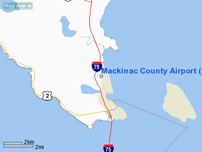
| From nearest city: | 2 nautical miles NW of St Ignace, MI |
| Location: | Mackinac County, MI |
| Magnetic Variation: | 06W (1990) |
Owner & Manager
| Ownership: | Publicly owned |
| Owner: | Mackinac Co Bd Of Commissioners |
| Address: | Court House, 110 S. Marley St
St Ignace, MI 49781 |
| Phone number: | 906-643-7300 |
| Manager: | Paul S. Fullerton |
| Address: | 1220 North State Street
St. Ignace, MI 49781 |
| Phone number: | 906-643-7165 |
Airport Operations and Facilities
| Airport Use: | Open to public |
| Wind indicator: | Yes |
| Segmented Circle: | Yes |
| Control Tower: | No |
| Lighting Schedule: | DUSK-DAWN
ACTVT MIRL RY 07/25 AND PAPI RYS 07 & 25 AND REIL RYS 07 & 25 AND RAMP LGTS - CTAF. |
| Beacon Color: | Clear-Green (lighted land airport) |
| Landing fee charge: | No |
| Sectional chart: | Lake Huron |
| Region: | AGL - Great Lakes |
| Boundary ARTCC: | ZMP - Minneapolis |
| Tie-in FSS: | GRB - Green Bay |
| FSS on Airport: | No |
| FSS Toll Free: | 1-800-WX-BRIEF |
| NOTAMs Facility: | GRB (NOTAM-d service avaliable) |
| Federal Agreements: | NGY |
Airport Communications
| CTAF: | 122.700 |
| Unicom: | 122.700 |
Airport Services
| Fuel available: | 100LL |
| Airframe Repair: | MAJOR |
| Power Plant Repair: | MAJOR |
| Bottled Oxygen: | NONE |
| Bulk Oxygen: | NONE |
Runway Information
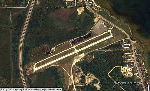
Runway 07/25
| Dimension: | 3800 x 75 ft / 1158.2 x 22.9 m |
| Surface: | CONC, Good Condition |
| Weight Limit: | Single wheel: 24000 lbs. |
| Edge Lights: | Medium |
| |
Runway 07 |
Runway 25 |
| Longitude: | 084-44-42.1509W | 084-43-52.4313W |
| Latitude: | 45-53-22.1071N | 45-53-36.3112N |
| Elevation: | 622.00 ft | 608.00 ft |
| Alignment: | 68 | 127 |
| Traffic Pattern: | Left | Left |
| Markings: | Basic, Good Condition
RY 7/25 MKG FADED | Basic, Good Condition |
| Crossing Height: | 33.00 ft | 21.00 ft |
| VASI: | 4-light PAPI on left side | 4-light PAPI on left side |
| Visual Glide Angle: | 4.00° | 3.00° |
| Runway End Identifier: | Yes | Yes |
| Obstruction: | 30 ft trees, 800.0 ft from runway, 125 ft left of centerline, 20:1 slope to clear
APCH RATIO 20:1 FM RY END OVR 100 FT TREES 2000 FT DSTC, 0 B, & +32 FT TREES, 64 FT DSTC, 200 FT L. | 5 ft road, 440.0 ft from runway, 125 ft right of centerline, 48:1 slope to clear |
|
Radio Navigation Aids
| ID |
Type |
Name |
Ch |
Freq |
Var |
Dist |
| CI | NDB | Koloe | | 400.00 | 06W | 27.7 nm |
| SJX | NDB | St James | | 382.00 | 05W | 36.4 nm |
| A | NDB | Gros Cap | | 286.00 | 06W | 37.7 nm |
| CVX | NDB | Charlevoix | | 392.00 | 05W | 41.9 nm |
| DRM | NDB | Drummond Island | | 218.00 | 07W | 42.2 nm |
| BFA | NDB | Boyne Falls | | 263.00 | 06W | 44.2 nm |
| PZQ | NDB | Rogers City | | 215.00 | 07W | 48.4 nm |
| SSM | VOR/DME | Sault Ste Marie | 059X | 112.20 | 04W | 35.9 nm |
| ERY | VOR/DME | Newberry | 019X | 108.20 | 06W | 39.5 nm |
| PLN | VORTAC | Pellston | 055X | 111.80 | 06W | 16.0 nm |
Remarks
- DEER & BIRDS ON & INVOF ARPT.
- MACKINAC ISLAND (MCD) AWOS 118.27 CAN BE RECD ON THE GROUND.
- PRIOR TO 1959.
Images and information placed above are from
http://www.airport-data.com/airport/83D/
We thank them for the data!
| General Info
|
| Country |
United States
|
| State |
MICHIGAN
|
| FAA ID |
83D
|
| Latitude |
45-53-30.000N
|
| Longitude |
084-44-17.000W
|
| Elevation |
623 feet
|
| Near City |
ST IGNACE
|
We don't guarantee the information is fresh and accurate. The data may
be wrong or outdated.
For more up-to-date information please refer to other sources.
|
|


