 |
|
Coordinates: 42°57′14″N 085°20′38″W / 42.95389°N 85.34389°W / 42.95389; -85.34389
| Lowell City Airport |
| IATA: none – ICAO: none – FAA LID: 24C |
| Summary |
| Airport type |
Public |
| Owner |
City of Lowell |
| Serves |
Lowell, Michigan |
| Elevation AMSL |
681 ft / 208 m |
| Runways |
| Direction |
Length |
Surface |
| ft |
m |
| 12/30 |
2,394 |
730 |
Asphalt |
| 6/24 |
2,700 |
823 |
Turf |
| 15/33 |
1,940 |
591 |
Turf |
| Statistics (2005) |
| Aircraft operations |
14,028 |
| Based aircraft |
20 |
| Source: Federal Aviation Administration |
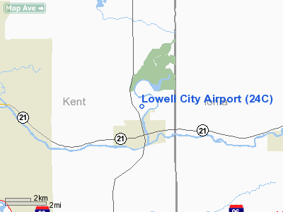
Lowell City Airport (FAA LID: 24C) is a city-owned public-use airport located one mile (2 km) north of the central business district of Lowell, a city in Kent County, Michigan, United States.
Facilities and aircraft
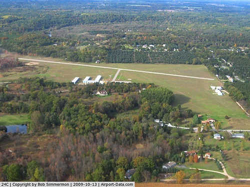
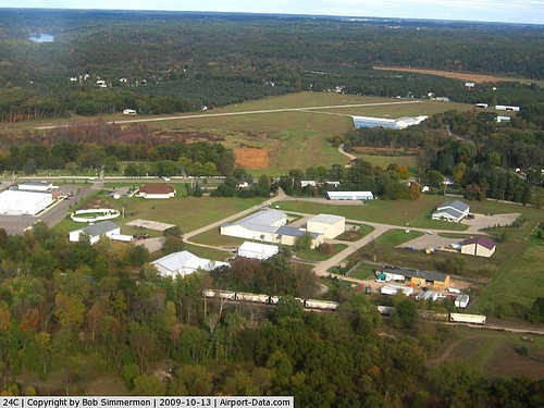
Lowell City Airport covers an area of 72 acres (29 ha) which contains one asphalt paved runway (12/30) measuring 2,394 x 48 ft (730 x 15 m), and two turf runways: 6/24 measuring 2,700 x 100 ft (823 x 30 m) and 15/33 measuring 1,940 x 100 ft (591 x 30 m).
For the 12-month period ending December 31, 2005, the airport had 14,028 general aviation aircraft operations, an average of 38 per day. At that time there were 20 aircraft based at this airport: 95% single-engine and 5% helicopter.
The above content comes from Wikipedia and is published under free licenses – click here to read more.
|
 |
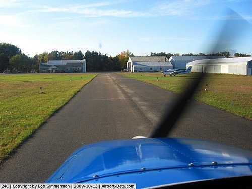
(Click on the photo to enlarge) |
|
 |
(Click on the photo to enlarge) |
|
 |
(Click on the photo to enlarge) |
|
 |
(Click on the photo to enlarge) |
Location & QuickFacts
| FAA Information Effective: | 2008-09-25 |
| Airport Identifier: | 24C |
| Airport Status: | Operational |
| Longitude/Latitude: | 085-20-38.0610W/42-57-14.1120N
-85.343906/42.953920 (Estimated) |
| Elevation: | 681 ft / 207.57 m (Surveyed) |
| Land: | 72 acres |
| From nearest city: | 1 nautical miles N of Lowell, MI |
| Location: | Kent County, MI |
| Magnetic Variation: | 04W (1985) |
Owner & Manager
| Ownership: | Publicly owned |
| Owner: | City Of Lowell |
| Address: | 301 E Main St
Lowell, MI 49331 |
| Phone number: | 616-897-5785 |
| Manager: | James W. Sowle |
| Address: | 770 Lincoln Lake Ave S
Lowell, MI 49331 |
| Phone number: | 616-897-2530 |
Airport Operations and Facilities
| Airport Use: | Open to public |
| Wind indicator: | Yes |
| Segmented Circle: | Yes |
| Control Tower: | No |
| Lighting Schedule: | RDO-CTL
ACTVT LIRL RY 12/30 - CTAF. |
| Landing fee charge: | No |
| Sectional chart: | Chicago |
| Region: | AGL - Great Lakes |
| Boundary ARTCC: | ZAU - Chicago |
| Tie-in FSS: | LAN - Lansing |
| FSS on Airport: | No |
| FSS Toll Free: | 1-800-WX-BRIEF |
| NOTAMs Facility: | LAN (NOTAM-d service avaliable) |
Airport Communications
| CTAF: | 123.000 |
| Unicom: | 123.000 |
Airport Services
| Fuel available: | 100LL |
| Airframe Repair: | MAJOR
AIRFRAME & POWER PLANT SCHOOL. |
| Power Plant Repair: | MAJOR |
| Bottled Oxygen: | NONE |
| Bulk Oxygen: | NONE |
Runway Information
Runway 06/24
| Dimension: | 2700 x 100 ft / 823.0 x 30.5 m |
| Surface: | TURF, Good Condition |
| |
Runway 06 |
Runway 24 |
| Longitude: | 085-20-52.4900W | 085-20-31.7100W |
| Latitude: | 42-57-10.8300N | 42-57-16.8700N |
| Elevation: | 681.00 ft | 681.00 ft |
| Traffic Pattern: | Left | Left |
| Markings: | Basic, Fair Condition | Basic, Fair Condition |
| Displaced threshold: | 1100.00 ft
RWY 06/24 & DSPLD THLDS MKD WITH 3 FT YELLOW CONES. | 1200.00 ft |
| Centerline Lights: | No | |
| Touchdown Lights: | No | No |
| Obstruction: | 35 ft trees, 7.0 ft from runway, 78 ft right of centerline
APCH RATIO 20:1 BASED ON 60 FT TREES, 70 FT R, 1200 FT DSTC FROM DSPLD THLD. | 40 ft trees, 27.0 ft from runway
APCH RATIO 14:1 AT DSPLD THLD, BASED ON 82 FT TREES, 1148 FT FM DSPLD THLD, 120 FT R. |
|
Runway 12/30
| Dimension: | 2394 x 48 ft / 729.7 x 14.6 m |
| Surface: | ASPH, Fair Condition |
| Edge Lights: | Low |
| |
Runway 12 |
Runway 30 |
| Longitude: | 085-20-55.5200W | 085-20-26.8800W |
| Latitude: | 42-57-21.5100N | 42-57-11.7000N |
| Elevation: | 681.00 ft | 681.00 ft |
| Traffic Pattern: | Left | Left |
| Markings: | Basic, Fair Condition | Basic, Fair Condition |
| Displaced threshold: | 603.00 ft | 597.00 ft |
| Touchdown Lights: | No | No |
| Obstruction: | 60 ft tree, 201.0 ft from runway, 100 ft left of centerline
RWY 12 APCH RATIO 0:1 AT DSPLCD THR; +52 FT TREE 0 FT FM DSPLCD THR 120 FT L.
12-20 FT DITCH NW END. | 40 ft trees, 201.0 ft from runway
APCH RATIO 12:1 AT DSPLCD THLD; 62 FT TREES 747 FT FROM DSPLCD THLD, 81 FT L.
RWY 30 30-50 FT TREES, L/R. |
|
Runway 15/33
| Dimension: | 1940 x 100 ft / 591.3 x 30.5 m |
| Surface: | TURF, Good Condition |
| |
Runway 15 |
Runway 33 |
| Longitude: | 085-20-38.9000W | 085-20-28.1000W |
| Latitude: | 42-57-18.0100N | 42-57-02.1000N |
| Elevation: | 681.00 ft | 681.00 ft |
| Traffic Pattern: | Left | Left |
| Markings: | Basic, Good Condition | Basic, Fair Condition |
| Displaced threshold: | 582.00 ft
RWY 15/33 & DSPLD THLDS MKD WITH 3 FT YELLOW CONES. | 388.00 ft |
| Touchdown Lights: | No | No |
| Obstruction: | 30 ft tree, 74.0 ft from runway, 87 ft right of centerline, 2:1 slope to clear
RWY 15 APCH RATIO 15:1 AT DSPLCD THR; 64 FT TREE 1017 FT FROM DSPLCD THR 135 FT R. | 25 ft pole, 23.0 ft from runway, 119 ft right of centerline
APCH RATIO 8:1 AT DSPLCD THLD; 60 FT TREE 486 FT DSTC 114 FT R. |
|
Radio Navigation Aids
| ID |
Type |
Name |
Ch |
Freq |
Var |
Dist |
| AMN | NDB | Alma | | 329.00 | 05W | 33.1 nm |
| BT | NDB | Batol | | 272.00 | 04W | 36.3 nm |
| HLM | NDB | Holland | | 233.00 | 03W | 37.1 nm |
| GRR | VOR/DME | Grand Rapids | 106Y | 115.95 | 04W | 12.1 nm |
| HIC | VOR/DME | White Cloud | 123X | 117.60 | 01W | 40.7 nm |
| AZO | VOR/DME | Kalamazoo | 027X | 109.00 | 01W | 44.1 nm |
| PMM | VOR/DME | Pullman | 058X | 112.10 | 00E | 44.6 nm |
| MOP | VOR/DME | Mount Pleasant | 043X | 110.60 | 05W | 48.2 nm |
| LAN | VORTAC | Lansing | 045X | 110.80 | 05W | 31.8 nm |
| MKG | VORTAC | Muskegon | 099X | 115.20 | 01W | 33.2 nm |
| BTL | VORTAC | Battle Creek | 031X | 109.40 | 02W | 38.9 nm |
Remarks
- SNOW REMOVAL RY 12/30 ONLY.
- EXISTED PRIOR TO 1959.
Images and information placed above are from
http://www.airport-data.com/airport/24C/
We thank them for the data!
| General Info
|
| Country |
United States
|
| State |
MICHIGAN
|
| FAA ID |
24C
|
| Latitude |
42-57-14.112N
|
| Longitude |
085-20-38.061W
|
| Elevation |
681 feet
|
| Near City |
LOWELL
|
We don't guarantee the information is fresh and accurate. The data may
be wrong or outdated.
For more up-to-date information please refer to other sources.
|
|


