 |
|
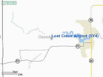
Location & QuickFacts
| FAA Information Effective: | 2008-09-25 |
| Airport Identifier: | 5Y4 |
| Airport Status: | Operational |
| Longitude/Latitude: | 084-14-15.0430W/44-39-36.0530N
-84.237512/44.660015 (Estimated) |
| Elevation: | 1051 ft / 320.34 m (Surveyed) |
| Land: | 77 acres |
| From nearest city: | 3 nautical miles NE of Luzerne, MI |
| Location: | Oscoda County, MI |
| Magnetic Variation: | 06W (1985) |
Owner & Manager
| Ownership: | Publicly owned |
| Owner: | Us Dept Of Agriculture |
| Address: | 107 Mckinley Rd
Mio, MI 48647 |
| Phone number: | 989-826-3252 |
| Manager: | Cliff Olson |
| Address: | 3605 Oakville Waltz Rd
New Boston, MI 48164-9669 |
| Phone number: | 734-772-1953
MGR RES 734-654-7933. |
Airport Operations and Facilities
| Airport Use: | Open to public |
| Wind indicator: | Yes |
| Segmented Circle: | No |
| Control Tower: | No |
| Landing fee charge: | No |
| Sectional chart: | Lake Huron |
| Region: | AGL - Great Lakes |
| Boundary ARTCC: | ZMP - Minneapolis |
| Tie-in FSS: | LAN - Lansing |
| FSS on Airport: | No |
| FSS Toll Free: | 1-800-WX-BRIEF |
| NOTAMs Facility: | LAN (NOTAM-d service avaliable) |
Airport Communications
Airport Services
Runway Information
Runway 05/23
| Dimension: | 2200 x 100 ft / 670.6 x 30.5 m |
| Surface: | TURF, Fair Condition |
| |
Runway 05 |
Runway 23 |
| Longitude: | 084-14-24.5000W | 084-14-06.5000W |
| Latitude: | 44-39-28.9600N | 44-39-46.5000N |
| Elevation: | 1051.00 ft | 1051.00 ft |
| Traffic Pattern: | Left | Left |
| Displaced threshold: | 200.00 ft | 415.00 ft |
| Runway End Identifier: | No | No |
| Centerline Lights: | No | No |
| Touchdown Lights: | No | No |
| Obstruction: | 25 ft trees, 60 ft left of centerline
APCH RATIO 0:1; FM DSPLCD THLD OVR +20 FT TREE, 0 FT DSTC, 100 FT L, 20:1 BASED ON STRAIGHT OUT OVR +52 FT TREES, 1040 FT DSTC. | 36 ft trees, 30.0 ft from runway, 126 ft left of centerline
APCH RATIO 8:1 AT DSPLCD THLD OVR + 21 FT TREE, 252 FT DSTC, 110 FT RT. APCH RATIO 20:1 BASED ON STRAIGHT OUT OVR +42 TREES, 840 FT DSTC. |
|
Runway 18/36
| Dimension: | 2600 x 100 ft / 792.5 x 30.5 m |
| Surface: | TURF, Fair Condition |
| |
Runway 18 |
Runway 36 |
| Longitude: | 084-14-12.5000W | 084-14-12.5000W |
| Latitude: | 44-39-47.6800N | 44-39-22.0000N |
| Elevation: | 1051.00 ft | 1051.00 ft |
| Traffic Pattern: | Left | Left |
| Displaced threshold: | 440.00 ft | 715.00 ft |
| Runway End Identifier: | No | No |
| Centerline Lights: | No | No |
| Touchdown Lights: | No | No |
| Obstruction: | 30 ft trees, 70L/ ft right of centerline
APCH RATIO 3:1 AT DSPLCD THLD OVER +30 FT TREES, 90 FT DSTC, 105 FT RIGHT; APCH RATIO 20:1 OVR +32 FT TREES, 640 FT DSTC, BASED ON STRAIGHT OUT. | 60 ft trees, 0.0 ft from runway, 120 ft right of centerline
APCH RATIO 4:1 AT DSPLCD THLD OVR + 20 FT TREES, 80 FT DSTC, 100 FT L. APCH RATIO 20;1 BASED ON STRAIGHT OUT. |
|
Radio Navigation Aids
| ID |
Type |
Name |
Ch |
Freq |
Var |
Dist |
| BHW | NDB | Hardwood | | 236.00 | 06W | 25.6 nm |
| GYG | NDB | Grayling | | 359.00 | 06W | 25.8 nm |
| BFA | NDB | Boyne Falls | | 263.00 | 06W | 42.1 nm |
| GDW | NDB | Wiggins | | 209.00 | 04W | 42.7 nm |
| CXK | NDB | Clam Lake | | 251.00 | 05W | 45.1 nm |
| PZQ | NDB | Rogers City | | 215.00 | 07W | 48.1 nm |
| CGG | VOR | Grayling | | 109.80 | 06W | 21.0 nm |
| BXZ | VOR/DME | West Branch | 079X | 113.20 | 06W | 25.2 nm |
| HTL | VOR/DME | Houghton Lake | 053X | 111.60 | 05W | 25.8 nm |
| GLR | VOR/DME | Gaylord | 029X | 109.20 | 06W | 29.1 nm |
| ASP | VOR/DME | Au Sable | 108X | 116.10 | 07W | 38.3 nm |
| APN | VORTAC | Alpena | 025X | 108.80 | 07W | 38.5 nm |
Remarks
- ARPT CLSD DEC THROUGH APRIL.
- DEER ON & INVOF ARPT.
- RY 36 FIRST 200 FT SOFT SAND.
- RC MODEL ACFT OPER S END OF RY 5/23.
- ESTABD PRIOR TO 1959.
Images and information placed above are from
http://www.airport-data.com/airport/5Y4/
We thank them for the data!
| General Info
|
| Country |
United States
|
| State |
MICHIGAN
|
| FAA ID |
5Y4
|
| Latitude |
44-39-36.053N
|
| Longitude |
084-14-15.043W
|
| Elevation |
1051 feet
|
| Near City |
LUZERNE
|
We don't guarantee the information is fresh and accurate. The data may
be wrong or outdated.
For more up-to-date information please refer to other sources.
|
|


