 |
|
|
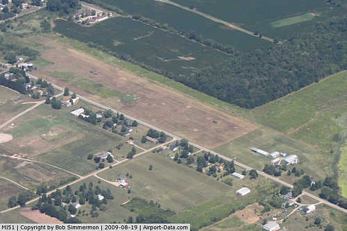 |
(Click on the photo to enlarge) |
|
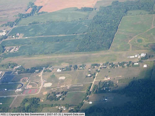 |
(Click on the photo to enlarge) |
|
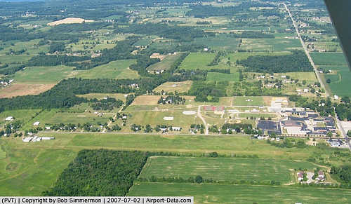 |
(Click on the photo to enlarge) |
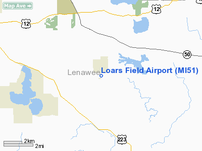
Location & QuickFacts
| FAA Information Effective: | 2008-09-25 |
| Airport Identifier: | MI51 |
| Airport Status: | Operational |
| Longitude/Latitude: | 084-11-19.0000W/41-59-48.9000N
-84.188611/41.996917 (Estimated) |
| Elevation: | 995 ft / 303.28 m (Estimated) |
| Land: | 14 acres |
| From nearest city: | 1 nautical miles S of Onsted, MI |
| Location: | Lenawee County, MI |
| Magnetic Variation: | 05W (1985) |
Owner & Manager
| Ownership: | Privately owned |
| Owner: | Dorothy J. Hallenbeck |
| Address: | 7620 Onsted Hwy
Onsted, MI 49265 |
| Phone number: | 517-467-7027 |
| Manager: | Milford Loar |
| Address: | 1100 Sunset Drive
Tecumseh, MI 49286 |
| Phone number: | 517-423-2496 |
Airport Operations and Facilities
| Airport Use: | Private |
| Wind indicator: | Yes |
| Segmented Circle: | Yes |
| Control Tower: | No |
| Lighting Schedule: | PHONE REQ
FOR LIRL RY 18/36 CALL 517-467-7027. |
| Landing fee charge: | No |
| Sectional chart: | Detroit |
| Region: | AGL - Great Lakes |
| Boundary ARTCC: | ZOB - Cleveland |
| Tie-in FSS: | LAN - Lansing |
| FSS on Airport: | No |
| FSS Toll Free: | 1-800-WX-BRIEF |
| NOTAMs Facility: | LAN (NOTAM-d service avaliable) |
Airport Services
| Airframe Repair: | NONE |
| Power Plant Repair: | NONE |
Runway Information
Runway 18/36
| Dimension: | 2600 x 80 ft / 792.5 x 24.4 m |
| Surface: | TURF, Fair Condition |
| Edge Lights: | Low
LIRL OTS INDEFLY. |
| |
Runway 18 |
Runway 36 |
| Longitude: | 084-11-14.9000W | 084-11-14.9000W |
| Latitude: | 41-59-56.8000N | 41-59-31.1000N |
| Alignment: | 127 | 0 |
| Traffic Pattern: | Left | Left |
| Runway End Identifier: | No | No |
| Centerline Lights: | No | No |
| Touchdown Lights: | No | No |
| Obstruction: | 40 ft pline, 400.0 ft from runway, 115 ft right of centerline, 10:1 slope to clear | 47 ft trees, 940.0 ft from runway, 20:1 slope to clear |
|
Radio Navigation Aids
| ID |
Type |
Name |
Ch |
Freq |
Var |
Dist |
| ADG | NDB | Adrian | | 278.00 | 06W | 9.1 nm |
| TCU | NDB | Tecumseh | | 239.00 | 04W | 14.0 nm |
| USE | NDB | Fulton | | 375.00 | 05W | 23.4 nm |
| BYN | NDB | Bryan | | 260.00 | 04W | 33.5 nm |
| OZW | NDB | Howell | | 243.00 | 05W | 39.3 nm |
| DFI | NDB | Defiance | | 246.00 | 05W | 41.2 nm |
| ANQ | NDB | Angola | | 347.00 | 05W | 45.6 nm |
| RYS | NDB | Grosse Ile | | 419.00 | 06W | 46.6 nm |
| BT | NDB | Batol | | 272.00 | 04W | 49.5 nm |
| TOL | TACAN | Toledo | 072X | | 05W | 29.9 nm |
| JXN | VOR/DME | Jackson | 033X | 109.60 | 05W | 19.8 nm |
| LFD | VOR/DME | Litchfield | 049X | 111.20 | 05W | 26.0 nm |
| DXO | VOR/DME | Detroit | 081X | 113.40 | 06W | 38.9 nm |
| VWV | VOR/DME | Waterville | 078X | 113.10 | 02W | 41.0 nm |
| CRL | VORTAC | Carleton | 104X | 115.70 | 03W | 32.8 nm |
| SVM | VORTAC | Salem | 090X | 114.30 | 03W | 36.2 nm |
| LAN | VORTAC | Lansing | 045X | 110.80 | 05W | 48.9 nm |
| YIP | VOT | Willow Run | | 112.00 | | 32.9 nm |
| DTW | VOT | Detroit Met Wayne | | 109.80 | | 39.3 nm |
Remarks
- 40' PLINES PARALLEL TO RY VARYING FM 100-135' ON WEST SIDE.
- DEER ON & INVOF ARPT.
- NO SNOW REMOVAL; CONFIRM COND WITH AMGR CALL 517-467-6721.
- RY 18; 34 FT TREES, 850 FT DSTC, APCH RATIO 25:1.
- NO SNOW REMOVAL; CONFIRM COND WITH AMGR CALL 517-467-7027.
- NON COMPLIANCE FAR 157.
Images and information placed above are from
http://www.airport-data.com/airport/MI51/
We thank them for the data!
We don't guarantee the information is fresh and accurate. The data may
be wrong or outdated.
For more up-to-date information please refer to other sources.
|
|


