 |
|
Livingston County Spencer J. Hardy Airport |
Coordinates: 42°37′46″N 083°58′56″W / 42.62944°N 83.98222°W / 42.62944; -83.98222
Livingston County
Spencer J. Hardy Airport |
| IATA: none – ICAO: KOZW – FAA LID: OZW |
| Summary |
| Airport type |
Public |
| Owner |
Livingston County |
| Location |
Howell, Michigan |
| Elevation AMSL |
962 ft / 293 m |
| Runways |
| Direction |
Length |
Surface |
| ft |
m |
| 13/31 |
5,002 |
1,525 |
Concrete |
| Statistics (2005) |
| Aircraft operations |
58,238 |
| Source: Federal Aviation Administration |
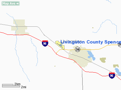
Livingston County Spencer J. Hardy Airport (ICAO: KOZW, FAA LID: OZW) is a county-owned public-use airport located three miles (5 km) northwest of the central business district of Howell, a city in Livingston County, Michigan, United States.
Although most U.S. airports use the same three-letter location identifier for the FAA and IATA, Livingston County Spencer J. Hardy Airport is assigned OZW by the FAA but has no designation from the IATA.
Facilities and aircraft
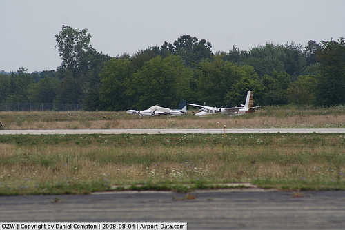
Livingston County Spencer J. Hardy Airport covers an area of 217 acres (88 ha) which contains one runway designated 13/31 with a 5,002 x 100 ft (1,525 x 30 m) concrete surface. For the 12-month period ending December 31, 2005, the airport had 58,238 general aviation aircraft operations, an average of 159 per day.
The airport is staffed Monday through Friday from 7 a.m. until 8 p.m., and Saturday and Sunday from 8 a.m. until 8 p.m. It is accessible by road from Grand River Avenue, and is close to M-59 and I-96.
The above content comes from Wikipedia and is published under free licenses – click here to read more.
|
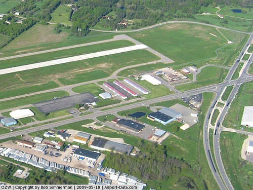 |
(Click on the photo to enlarge) |
|
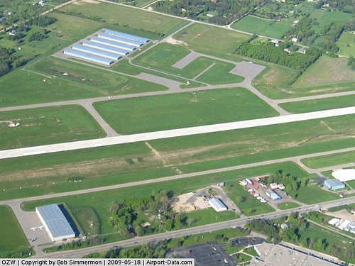 |
(Click on the photo to enlarge) |
|
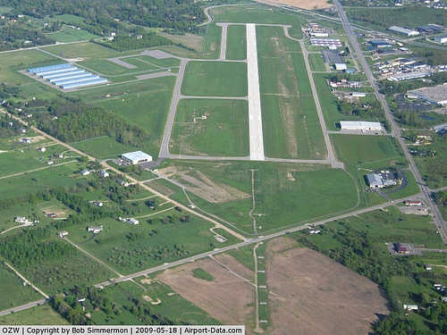 |
(Click on the photo to enlarge) |
|
 |
(Click on the photo to enlarge) |
Location & QuickFacts
| FAA Information Effective: | 2008-09-25 |
| Airport Identifier: | OZW |
| Airport Status: | Operational |
| Longitude/Latitude: | 083-58-55.8950W/42-37-45.9400N
-83.982193/42.629428 (Estimated) |
| Elevation: | 962 ft / 293.22 m (Surveyed) |
| Land: | 217 acres |
| From nearest city: | 3 nautical miles NW of Howell, MI |
| Location: | Livingston County, MI |
| Magnetic Variation: | 05W (1990) |
Owner & Manager
| Ownership: | Publicly owned |
| Owner: | Livingston County |
| Address: | 304 E Grand River Ave
Howell, MI 48843 |
| Phone number: | 517-546-3520 |
| Manager: | Mark D. Johnson |
| Address: | 3480 W Grand River Ave
Howell, MI 48855 |
| Phone number: | 517-546-6675 |
Airport Operations and Facilities
| Airport Use: | Open to public |
| Wind indicator: | Yes |
| Segmented Circle: | Yes |
| Control Tower: | No |
| Lighting Schedule: | DUSK-DAWN
HIRL RY 13/31 OPER LOW INTST DUSK-2200; TO INCR INTST & ACTVT AFT 2200 - CTAF. ACTVT REIL RY 31 & MALSR RY 13 - CTAF. PAPI RYS 13 & 31 OPER DAWN-DUSK, THEREAFTER - CTAF. |
| Beacon Color: | Clear-Green (lighted land airport) |
| Landing fee charge: | No |
| Sectional chart: | Detroit |
| Region: | AGL - Great Lakes |
| Traffic Pattern Alt: | 1039 ft |
| Boundary ARTCC: | ZOB - Cleveland |
| Tie-in FSS: | LAN - Lansing |
| FSS on Airport: | No |
| FSS Toll Free: | 1-800-WX-BRIEF |
| NOTAMs Facility: | OZW (NOTAM-d service avaliable) |
| Federal Agreements: | NGY |
Airport Communications
| CTAF: | 123.000 |
| Unicom: | 123.000 |
Airport Services
| Fuel available: | 100LLA |
| Airframe Repair: | MAJOR |
| Power Plant Repair: | MAJOR |
Runway Information
Runway 13/31
| Dimension: | 5002 x 100 ft / 1524.6 x 30.5 m |
| Surface: | CONC, Good Condition |
| Surface Treatment: | Saw-cut or plastic Grooved |
| Weight Limit: | Single wheel: 30000 lbs. |
| Edge Lights: | High |
| |
Runway 13 |
Runway 31 |
| Longitude: | 083-59-22.4900W | 083-58-29.3000W |
| Latitude: | 42-38-00.9300N | 42-37-30.9500N |
| Elevation: | 962.00 ft | 943.00 ft |
| Alignment: | 127 | 127 |
| ILS Type: | ILS/DME
| |
| Traffic Pattern: | Left | Left |
| Markings: | Precision instrument, Good Condition | Precision instrument, Good Condition |
| Crossing Height: | 47.00 ft | 30.00 ft |
| VASI: | 4-light PAPI on left side
PAPI OTS INDEFLY. | 4-light PAPI on left side |
| Visual Glide Angle: | 3.00° | 3.00° |
| Approach lights: | MALSR | |
| Runway End Identifier: | No | Yes |
| Obstruction: | 25 ft trees, 1024.0 ft from runway, 620 ft left of centerline, 32:1 slope to clear | 46 ft trees, 1764.0 ft from runway, 265 ft left of centerline, 34:1 slope to clear |
|
Radio Navigation Aids
| ID |
Type |
Name |
Ch |
Freq |
Var |
Dist |
| OZW | NDB | Howell | | 243.00 | 05W | 0.4 nm |
| TCU | NDB | Tecumseh | | 239.00 | 04W | 35.9 nm |
| ADG | NDB | Adrian | | 278.00 | 06W | 45.8 nm |
| G | NDB | Golf | | 398.00 | 05W | 47.5 nm |
| VQ | NDB | Cargl | | 230.00 | 05W | 48.4 nm |
| HYX | NDB | Browne | | 385.00 | 06W | 48.5 nm |
| RYS | NDB | Grosse Ile | | 419.00 | 06W | 48.6 nm |
| JXN | VOR/DME | Jackson | 033X | 109.60 | 05W | 30.7 nm |
| DXO | VOR/DME | Detroit | 081X | 113.40 | 06W | 37.0 nm |
| LFD | VOR/DME | Litchfield | 049X | 111.20 | 05W | 48.7 nm |
| PSI | VORTAC | Pontiac | 047X | 111.00 | 03W | 20.3 nm |
| SVM | VORTAC | Salem | 090X | 114.30 | 03W | 21.7 nm |
| FNT | VORTAC | Flint | 116X | 116.90 | 06W | 22.8 nm |
| LAN | VORTAC | Lansing | 045X | 110.80 | 05W | 32.1 nm |
| CRL | VORTAC | Carleton | 104X | 115.70 | 03W | 42.0 nm |
| YIP | VOT | Willow Run | | 112.00 | | 31.3 nm |
| DTW | VOT | Detroit Met Wayne | | 109.80 | | 36.5 nm |
| DET | VOT | Detroit City | | 111.60 | | 44.9 nm |
Remarks
- DEER & BIRDS ON & INVOF ARPT.
- GCO AVBL ON FREQ 121.725 THRU DTW CLNC DEL & FLT SVCS.
Images and information placed above are from
http://www.airport-data.com/airport/OZW/
We thank them for the data!
| General Info
|
| Country |
United States
|
| State |
MICHIGAN
|
| FAA ID |
OZW
|
| Latitude |
42-37-46.200N
|
| Longitude |
083-59-03.000W
|
| Elevation |
960 feet
|
| Near City |
HOWELL
|
We don't guarantee the information is fresh and accurate. The data may
be wrong or outdated.
For more up-to-date information please refer to other sources.
|
|


