 |
|
Coordinates: 41°52′04″N 084°04′38″W / 41.86778°N 84.07722°W / 41.86778; -84.07722
| Lenawee County Airport |
 |
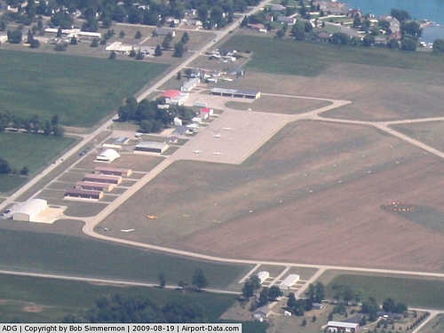
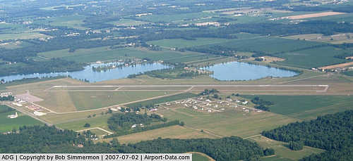
| Tarmac, hangar and terminal area |
| IATA: ADG – ICAO: KADG – FAA LID: ADG |
| Summary |
| Airport type |
Public |
| Owner |
Lenawee County |
| Location |
Adrian, Michigan |
| Elevation AMSL |
798 ft / 243 m |
| Website |
www.lenawee.mi.us/airport/ |
| Runways |
| Direction |
Length |
Surface |
| ft |
m |
| 5/23 |
5,001 |
1,524 |
Asphalt |
| 11/29 |
1,810 |
552 |
Turf |
| Statistics (2003) |
| Aircraft operations |
51,200 |
| Based aircraft |
50 |
| Source: Federal Aviation Administration |
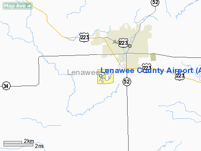
Lenawee County Airport (IATA: ADG, ICAO: KADG, FAA LID: ADG) is a county-owned public-use airport located three miles (5 km) southwest of the central business district of Adrian, a city in Lenawee County, Michigan, United States. The airport is accessible by road from Cadmus Rd, and is close to US-223.
The Lenawee County Airport is the closest airport to Michigan International Speedway, the Irish Hills, and Michigan State University's Hidden Lake Gardens. Siena Heights University, Adrian College, and Jackson Community College Lenawee Campus are just a few miles away. LCA's arrival and departure process centrally located between Ann Arbor and Jackson, Michigan, and Toledo, Ohio. The airport is staffed between 8AM and dusk.
Facilities and aircraft
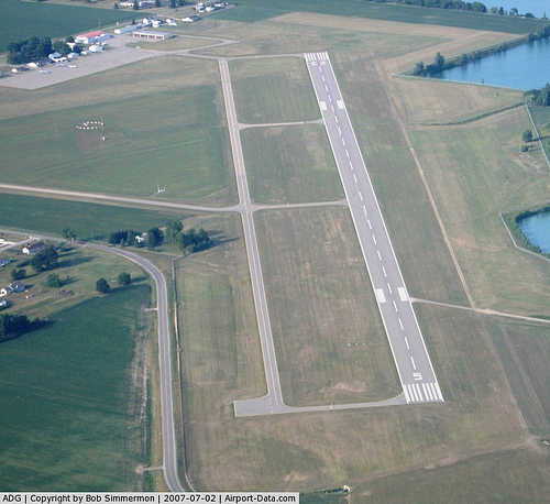
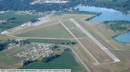
Lenawee County Airport covers an area of 248 acres (1.00 km) which contains two runways: 5/23 has an asphalt pavement measuring 5,001 x 100 ft. (1,524 x 30 m) and 11/29 has a turf surface measuring 1,810 x 150 ft. (552 x 46 m).
For the 12-month period ending December 31, 2003, the airport had 51,200 aircraft operations, an average of 140 per day, all of which were general aviation. There are 50 aircraft based at this airport: 80% single-engine, 10% glider, 4% multi-engine, 4% jet and 2% ultralight.
The above content comes from Wikipedia and is published under free licenses – click here to read more.
|
 |
(Click on the photo to enlarge) |
|
 |
(Click on the photo to enlarge) |
|
 |
(Click on the photo to enlarge) |
|
 |
(Click on the photo to enlarge) |
Location & QuickFacts
| FAA Information Effective: | 2008-09-25 |
| Airport Identifier: | ADG |
| Airport Status: | Operational |
| Longitude/Latitude: | 084-04-38.3010W/41-52-03.6260N
-84.077306/41.867674 (Estimated) |
| Elevation: | 798 ft / 243.23 m (Surveyed) |
| Land: | 248 acres |
| From nearest city: | 3 nautical miles SW of Adrian, MI |
| Location: | Lenawee County, MI |
| Magnetic Variation: | 06W (2000) |
Owner & Manager
| Ownership: | Publicly owned |
| Owner: | Lenawee County |
| Address: | 301 N. Main St.
Adrian, MI 49221 |
| Phone number: | 517-265-2827 |
| Manager: | Joseph Malak |
| Address: | 2667 Cadmus Rd
Adrian, MI 49221 |
| Phone number: | 517-265-2827 |
Airport Operations and Facilities
| Airport Use: | Open to public |
| Wind indicator: | Yes |
| Segmented Circle: | Yes |
| Control Tower: | No |
| Lighting Schedule: | DUSK-DAWN
HIRL RY 05/23 PRESET LOW INTST; TO INCR INTST & ACTVT PAPI RYS 05 & 23 - CTAF. |
| Beacon Color: | Clear-Green (lighted land airport) |
| Landing fee charge: | No |
| Sectional chart: | Detroit |
| Region: | AGL - Great Lakes |
| Boundary ARTCC: | ZOB - Cleveland |
| Tie-in FSS: | LAN - Lansing |
| FSS on Airport: | No |
| FSS Toll Free: | 1-800-WX-BRIEF |
| NOTAMs Facility: | ADG (NOTAM-d service avaliable) |
| Federal Agreements: | NGY |
Airport Communications
| CTAF: | 122.800 |
| Unicom: | 122.800 |
Airport Services
| Fuel available: | 100LLA
24 HR SELF SERVE FUEL (100 LL ONLY) WITH CREDIT CARD. |
Runway Information
Runway 05/23
| Dimension: | 5001 x 100 ft / 1524.3 x 30.5 m |
| Surface: | ASPH, Good Condition |
| Weight Limit: | Single wheel: 20000 lbs. |
| Edge Lights: | High
RY 05/23 PERIMETER TWY MARKED WITH REFLECTORS. |
| |
Runway 05 |
Runway 23 |
| Longitude: | 084-05-05.0121W | 084-04-16.4794W |
| Latitude: | 41-51-41.7969N | 41-52-15.3367N |
| Elevation: | 794.00 ft | 798.00 ft |
| Alignment: | 47 | 127 |
| Traffic Pattern: | Left | Left |
| Markings: | Non-precision instrument, Fair Condition | Non-precision instrument, Fair Condition |
| Crossing Height: | 32.00 ft | 32.00 ft |
| VASI: | 4-light PAPI on left side | 4-light PAPI on left side |
| Visual Glide Angle: | 3.00° | 3.00° |
| Runway End Identifier: | Yes | |
| Centerline Lights: | No | No |
| Touchdown Lights: | No | No |
| Obstruction: | 36 ft pline, 1469.0 ft from runway, 35:1 slope to clear | 47 ft trees, 1388.0 ft from runway, 25:1 slope to clear |
|
Runway 11/29
| Dimension: | 1810 x 150 ft / 551.7 x 45.7 m |
| Surface: | TURF, Good Condition |
| |
Runway 11 |
Runway 29 |
| Longitude: | 084-04-43.0000W | 084-04-20.1000W |
| Latitude: | 41-52-20.2000N | 41-52-15.0000N |
| Elevation: | 798.00 ft | 797.00 ft |
| Alignment: | 107 | 127 |
| Traffic Pattern: | Left | Left |
| Runway End Identifier: | No | No |
| Centerline Lights: | No | No |
| Touchdown Lights: | No | No |
| Obstruction: | 99 ft trees, 1980.0 ft from runway, 20:1 slope to clear | 38 ft trees, 1230.0 ft from runway, 32:1 slope to clear |
|
Radio Navigation Aids
| ID |
Type |
Name |
Ch |
Freq |
Var |
Dist |
| ADG | NDB | Adrian | | 278.00 | 06W | 0.1 nm |
| TCU | NDB | Tecumseh | | 239.00 | 04W | 13.4 nm |
| USE | NDB | Fulton | | 375.00 | 05W | 15.7 nm |
| BYN | NDB | Bryan | | 260.00 | 04W | 29.1 nm |
| DFI | NDB | Defiance | | 246.00 | 05W | 35.7 nm |
| RYS | NDB | Grosse Ile | | 419.00 | 06W | 43.6 nm |
| OZW | NDB | Howell | | 243.00 | 05W | 46.2 nm |
| ANQ | NDB | Angola | | 347.00 | 05W | 47.3 nm |
| TOL | TACAN | Toledo | 072X | | 05W | 20.7 nm |
| JXN | VOR/DME | Jackson | 033X | 109.60 | 05W | 29.0 nm |
| VWV | VOR/DME | Waterville | 078X | 113.10 | 02W | 31.8 nm |
| LFD | VOR/DME | Litchfield | 049X | 111.20 | 05W | 32.9 nm |
| DXO | VOR/DME | Detroit | 081X | 113.40 | 06W | 37.9 nm |
| CRL | VORTAC | Carleton | 104X | 115.70 | 03W | 29.7 nm |
| SVM | VORTAC | Salem | 090X | 114.30 | 03W | 39.0 nm |
| YIP | VOT | Willow Run | | 112.00 | | 33.1 nm |
| DTW | VOT | Detroit Met Wayne | | 109.80 | | 38.5 nm |
Remarks
- SNOW REMOVAL RY 05/23 ONLY.
- TAXI ON HARD SFCS ONLY DURG SPRING THAW & WET CONDTIONS.
- EXTENSIVE GLIDER OPNS WKENDS.
- LANDING FEE FOR COMM A/C - WAIVED W/FUEL PURCHASE.
Images and information placed above are from
http://www.airport-data.com/airport/ADG/
We thank them for the data!
| General Info
|
| Country |
United States
|
| State |
MICHIGAN
|
| FAA ID |
ADG
|
| Latitude |
41-52-09.972N
|
| Longitude |
084-04-29.299W
|
| Elevation |
798 feet
|
| Near City |
ADRIAN
|
We don't guarantee the information is fresh and accurate. The data may
be wrong or outdated.
For more up-to-date information please refer to other sources.
|
|


