 |
|
|
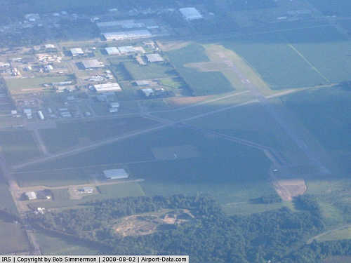 |
(Click on the photo to enlarge) |
|
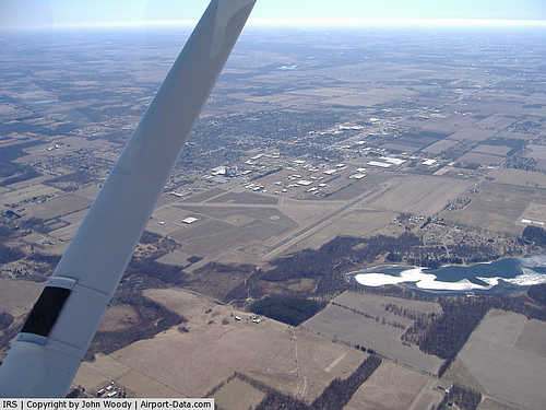 |
(Click on the photo to enlarge) |
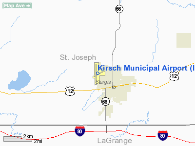
Location & QuickFacts
| FAA Information Effective: | 2008-09-25 |
| Airport Identifier: | IRS |
| Airport Status: | Operational |
| Longitude/Latitude: | 085-26-20.1000W/41-48-48.0000N
-85.438917/41.813333 (Estimated) |
| Elevation: | 924 ft / 281.64 m (Surveyed) |
| Land: | 148 acres |
| From nearest city: | 2 nautical miles NW of Sturgis, MI |
| Location: | St Joseph County, MI |
| Magnetic Variation: | 04W (1995) |
Owner & Manager
| Ownership: | Publicly owned |
| Owner: | City Of Sturgis |
| Address: | 130 N. Nottawa
Sturgis, MI 49091-1433 |
| Phone number: | 269-651-2321
ASST MGR 269-651-2322 |
| Manager: | Michael Hughes, City/airport Mgr
ASST MGR/FBO BRIAN RILEY; CALL 269-651-2821. |
| Address: | 130 North Nottawa St, P O Box 280
Sturgis, MI 49091-1433 |
| Phone number: | 269-651-2821 |
Airport Operations and Facilities
| Airport Use: | Open to public |
| Wind indicator: | Yes |
| Segmented Circle: | Yes |
| Control Tower: | No |
| Lighting Schedule: | DUSK-DAWN
ACTVT MIRL RYS 06/24 & 18/36, REIL RYS 18 & 24, PAPI RYS 24, 18, 36 - CTAF. |
| Beacon Color: | Clear-Green (lighted land airport) |
| Landing fee charge: | No |
| Sectional chart: | Chicago |
| Region: | AGL - Great Lakes |
| Traffic Pattern Alt: | 1000 ft |
| Boundary ARTCC: | ZAU - Chicago |
| Tie-in FSS: | LAN - Lansing |
| FSS on Airport: | No |
| FSS Toll Free: | 1-800-WX-BRIEF |
| NOTAMs Facility: | IRS (NOTAM-d service avaliable) |
| Federal Agreements: | NGY |
Airport Communications
| CTAF: | 123.050 |
| Unicom: | 123.050 |
Airport Services
| Fuel available: | 100LLA1+ |
| Airframe Repair: | MAJOR |
| Power Plant Repair: | MAJOR |
| Bottled Oxygen: | LOW |
Runway Information
Runway 06/24
| Dimension: | 3451 x 75 ft / 1051.9 x 22.9 m |
| Surface: | ASPH, Fair Condition |
| Weight Limit: | Single wheel: 19000 lbs.
Dual wheel: 25000 lbs.
Dual tandem wheel: 58000 lbs. |
| Edge Lights: | Medium
OTS INDEFLY. |
| |
Runway 06 |
Runway 24 |
| Longitude: | 085-26-28.9157W | 085-25-49.9885W |
| Latitude: | 41-48-40.3938N | 41-48-58.1127N |
| Elevation: | 913.00 ft | 924.00 ft |
| Alignment: | 59 | 127 |
| Traffic Pattern: | Left | Left |
| Markings: | Basic, Good Condition | Basic, Good Condition |
| Crossing Height: | 0.00 ft | 22.00 ft |
| VASI: | | 2-light PAPI on left side |
| Visual Glide Angle: | 0.00° | 4.00° |
| Runway End Identifier: | | Yes |
| Obstruction: | 54 ft trees, 1095.0 ft from runway, 377 ft left of centerline, 16:1 slope to clear
APCH RATIO RWY END IS 20:1 | 59 ft trees, 1444.0 ft from runway, 120 ft left of centerline, 21:1 slope to clear |
|
Runway 18/36
| Dimension: | 5200 x 100 ft / 1585.0 x 30.5 m |
| Surface: | ASPH, Good Condition |
| Weight Limit: | Single wheel: 47000 lbs.
Dual wheel: 57500 lbs.
Dual tandem wheel: 90000 lbs. |
| Edge Lights: | Medium
OTS INDEFLY. |
| |
Runway 18 |
Runway 36 |
| Longitude: | 085-26-27.3363W | 085-26-26.9710W |
| Latitude: | 41-49-12.8065N | 41-48-21.4399N |
| Elevation: | 908.00 ft | 912.00 ft |
| Alignment: | 127 | 127 |
| Traffic Pattern: | Left | Left |
| Markings: | Non-precision instrument, Good Condition | Non-precision instrument, Good Condition |
| Crossing Height: | 27.00 ft | 26.00 ft |
| VASI: | 4-light PAPI on left side | 4-light PAPI on left side |
| Visual Glide Angle: | 3.00° | 3.00° |
| Runway End Identifier: | Yes | Yes |
| Centerline Lights: | No | No |
| Touchdown Lights: | No | No |
| Obstruction: | 61 ft tree, 2403.0 ft from runway, 125 ft right of centerline, 36:1 slope to clear
APCH RATIO AT RWY END IS 16:1 | 42 ft tree, 1664.0 ft from runway, 200 ft left of centerline, 34:1 slope to clear |
|
Radio Navigation Aids
| ID |
Type |
Name |
Ch |
Freq |
Var |
Dist |
| IRS | NDB | Sturgis | | 382.00 | 04W | 0.2 nm |
| HAI | NDB | Three Rivers | | 407.00 | 02W | 11.1 nm |
| ANQ | NDB | Angola | | 347.00 | 05W | 18.9 nm |
| BT | NDB | Batol | | 272.00 | 04W | 34.9 nm |
| BYN | NDB | Bryan | | 260.00 | 04W | 48.1 nm |
| OLK | VOR | Wolf Lake | | 110.40 | 03W | 34.1 nm |
| AZO | VOR/DME | Kalamazoo | 027X | 109.00 | 01W | 26.0 nm |
| LFD | VOR/DME | Litchfield | 049X | 111.20 | 05W | 33.6 nm |
| ELX | VOR/DME | Keeler | 113X | 116.60 | 00E | 36.5 nm |
| PMM | VOR/DME | Pullman | 058X | 112.10 | 00E | 49.2 nm |
| BTL | VORTAC | Battle Creek | 031X | 109.40 | 02W | 31.0 nm |
| GSH | VORTAC | Goshen | 084X | 113.70 | 00E | 31.6 nm |
| GIJ | VORTAC | Gipper | 101X | 115.40 | 00E | 39.5 nm |
Images and information placed above are from
http://www.airport-data.com/airport/IRS/
We thank them for the data!
| General Info
|
| Country |
United States
|
| State |
MICHIGAN
|
| FAA ID |
IRS
|
| Latitude |
41-48-46.341N
|
| Longitude |
085-26-20.620W
|
| Elevation |
925 feet
|
| Near City |
STURGIS
|
We don't guarantee the information is fresh and accurate. The data may
be wrong or outdated.
For more up-to-date information please refer to other sources.
|
|


