 |
|
James Clements Municipal Airport |
|
|
| James Clements Municipal Airport |
| IATA: none – ICAO: none – FAA LID: 3 CM |
| Summary |
| Airport type |
Public |
| Owner |
Bay City |
| Location |
Bay City, Michigan |
| Elevation AMSL |
585 ft / 178 m |
| Coordinates |
43°32′49″N 083°53′44″W / 43.54694°N 83.89556°W / 43.54694; -83.89556 |
| Runways |
| Direction |
Length |
Surface |
| ft |
m |
| 5/23 |
2,599 |
792 |
Asphalt |
| 18/36 |
3,798 |
1,158 |
Asphalt |
| 9W/27W |
3,500 |
1,067 |
Water |
| 13W/31W |
2,600 |
792 |
Water |
| 18W/36W |
3,500 |
1,067 |
Water |
| Statistics (2005) |
| Aircraft operations |
11,490 |
| Based aircraft |
57 |
| Source: Federal Aviation Administration |
| James Clements Airport Administration Building |
| U.S. National Register of Historic Places |
| Michigan State Historic Site |
|
|
| Location: |
Bay City, Michigan |
| Coordinates: |
43°32′52″N 83°53′31″W / 43.54778°N 83.89194°W / 43.54778; -83.89194Coordinates: 43°32′52″N 83°53′31″W / 43.54778°N 83.89194°W / 43.54778; -83.89194 |
| Built/Founded: |
1929 |
| Architect: |
Goddeyne,Joseph C.; Webber,Construction Co. |
| Architectural style(s): |
Colonial Revival, Other |
| Governing body: |
Local |
| Added to NRHP: |
November 22, 1982 |
| Designated MSHS: |
April 21, 1980 |
| NRHP Reference#: |
82000494 |
|
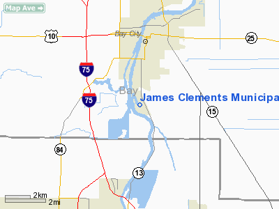
James Clements Municipal Airport (FAA LID: 3CM) is a public airport located three miles (5 km) south of the central business district of Bay City, in Bay County, Michigan, United States. This airport is publicly owned by Bay City.
The airport was dedicated in 1930 in commemoration of Bay City pilots who gave their lives for their country in military service. The Georgian Revival Administration Building became part of to the National Register of Historic Places in 1982, and houses a collection of photographs of those pilots.
It is home port for local chapters of the Civil Air Patrol and the Experimental Aircraft Association. Also centered there is the Valley Aero Club (which celebrates Fathers' Day with an annual fly-in breakfast in early June; and also hosts an air show in August.).
Wetlands on the airport's edges are home to the cream-colored Eastern Prairie Fringed Orchid, which is a threatened and rare wildflower.
Facilities and aircraft
James Clements Municipal Airport covers an area of 266 acres (108 ha) which contains two runways and three seaplane lanes:
- 5/23: 2,599 x 75 ft (792 x 23 m), Surface: Asphalt
- 18/36: 3,798 x 75 ft (1,158 x 23 m), Surface: Asphalt
- 9W/27W: 3,500 x 500 ft (1,067 x 152 m), Surface: Water
- 13W/31W: 2,600 x 400 ft (792 x 122 m), Surface: Water
- 18W/36W: 3,500 x 500 ft (1,067 x 152 m), Surface: Water
For 12-month period ending December 31, 2005, the airport had 11,490 general aviation aircraft operations, an average of 31 per day. There are 57 aircraft based at this airport: 88% single engine (50), 9% multi engine (5), 2% jet aircraft (1) and 2% helicopters (1).
The above content comes from Wikipedia and is published under free licenses – click here to read more.
Location & QuickFacts
| FAA Information Effective: | 2008-09-25 |
| Airport Identifier: | 3CM |
| Airport Status: | Operational |
| Longitude/Latitude: | 083-53-43.7000W/43-32-49.0000N
-83.895472/43.546944 (Estimated) |
| Elevation: | 585 ft / 178.31 m (Surveyed) |
| Land: | 266 acres |
| From nearest city: | 3 nautical miles S of Bay City, MI |
| Location: | Bay County, MI |
| Magnetic Variation: | 04W (1980) |
Owner & Manager
| Ownership: | Publicly owned |
| Owner: | Bay City |
| Address: | 301 Washington Ave.
Bay City, MI 48708 |
| Phone number: | 989-894-8229
CITY ENGINEERING DEPT. |
| Manager: | Douglas Dodge |
| Address: | 614 S. River Rd
Bay City, MI 48708 |
| Phone number: | 989-895-8991 |
Airport Operations and Facilities
| Airport Use: | Open to public |
| Wind indicator: | Yes |
| Segmented Circle: | Yes |
| Control Tower: | No |
| Lighting Schedule: | DUSK-DAWN
ACTVT MIRL RYS 18/36 & 05/23, PAPI RYS 23, 18 & 36 - CTAF. |
| Beacon Color: | Clear-Green (lighted land airport) |
| Landing fee charge: | No |
| Sectional chart: | Detroit |
| Region: | AGL - Great Lakes |
| Boundary ARTCC: | ZOB - Cleveland |
| Tie-in FSS: | LAN - Lansing |
| FSS on Airport: | No |
| FSS Toll Free: | 1-800-WX-BRIEF |
| NOTAMs Facility: | LAN (NOTAM-d service avaliable) |
| Federal Agreements: | NGY |
Airport Communications
| CTAF: | 122.800 |
| Unicom: | 122.800 |
Airport Services
| Fuel available: | 100LL |
| Airframe Repair: | MAJOR |
| Power Plant Repair: | MAJOR |
| Bottled Oxygen: | NONE |
Runway Information
Runway 05/23
| Dimension: | 2599 x 75 ft / 792.2 x 22.9 m |
| Surface: | ASPH, Fair Condition |
| Edge Lights: | Medium
TWYS MARKED WITH REFLECTORS. |
| |
Runway 05 |
Runway 23 |
| Longitude: | 083-53-59.0481W | 083-53-34.2038W |
| Latitude: | 43-32-38.4751N | 43-32-56.7085N |
| Elevation: | 584.00 ft | 584.00 ft |
| Alignment: | 45 | 127 |
| Traffic Pattern: | Left | Left |
| Markings: | Basic, Fair Condition | Basic, Fair Condition |
| Crossing Height: | 0.00 ft | 27.00 ft |
| Displaced threshold: | 226.00 ft | 159.00 ft |
| VASI: | | 2-light PAPI on left side |
| Visual Glide Angle: | 0.00° | 4.00° |
| Runway End Identifier: | No | No |
| Centerline Lights: | No | No |
| Touchdown Lights: | No | No |
| Obstruction: | 40 ft trees, 1120.0 ft from runway, 130L/ ft right of centerline, 23:1 slope to clear
APCH RATIO 34:1 AT DSPLCD THR.
DIKE +4 FT HIGH 85 FT FM THR. | 20 ft road, 260.0 ft from runway, 125 ft left of centerline, 3:1 slope to clear
APCH RATIO 20:1 AT DSPLCD THLD. |
|
Runway 09W/27W
| Dimension: | 3500 x 500 ft / 1066.8 x 152.4 m |
| Surface: | WATER, |
| |
Runway 09W |
Runway 27W |
| Traffic Pattern: | Left | Left |
| Markings: | None, | None, |
| Runway End Identifier: | No | No |
| Centerline Lights: | No | No |
| Touchdown Lights: | No | No |
|
Runway 13W/31W
| Dimension: | 2600 x 400 ft / 792.5 x 121.9 m |
| Surface: | WATER, |
| |
Runway 13W |
Runway 31W |
| Traffic Pattern: | Left | Left |
| Markings: | None, | None, |
| Runway End Identifier: | No | No |
| Centerline Lights: | No | No |
| Touchdown Lights: | No | No |
|
Runway 18/36
| Dimension: | 3798 x 75 ft / 1157.6 x 22.9 m |
| Surface: | ASPH, Fair Condition |
| Edge Lights: | Medium
TWYS MARKED WITH REFLECTORS. |
| |
Runway 18 |
Runway 36 |
| Longitude: | 083-53-43.4217W | 083-53-40.0160W |
| Latitude: | 43-33-08.6193N | 43-32-31.1893N |
| Elevation: | 584.00 ft | 582.00 ft |
| Alignment: | 127 | 127 |
| Traffic Pattern: | Left | Left |
| Markings: | Non-precision instrument, Fair Condition | Non-precision instrument, Fair Condition |
| Crossing Height: | 27.00 ft | 27.00 ft |
| VASI: | 4-light PAPI on left side | 4-light PAPI on left side |
| Visual Glide Angle: | 4.00° | 4.00° |
| Runway End Identifier: | No | No |
| Centerline Lights: | No | No |
| Touchdown Lights: | No | No |
| Obstruction: | 22 ft trees, 290.0 ft from runway, 125 ft right of centerline, 4:1 slope to clear | 8 ft brush, 201.0 ft from runway, 90 ft left of centerline
8 FT BRUSH, 100 FT L, 195 FT DSTC |
|
Runway 18W/36W
| Dimension: | 3500 x 500 ft / 1066.8 x 152.4 m |
| Surface: | WATER, |
| |
Runway 18W |
Runway 36W |
| Traffic Pattern: | Left | Left |
| Markings: | None, | None, |
| Runway End Identifier: | No | No |
| Centerline Lights: | No | No |
| Touchdown Lights: | No | No |
|
Radio Navigation Aids
| ID |
Type |
Name |
Ch |
Freq |
Var |
Dist |
| HYX | NDB | Browne | | 385.00 | 06W | 7.1 nm |
| GDW | NDB | Wiggins | | 209.00 | 04W | 35.8 nm |
| AMN | NDB | Alma | | 329.00 | 05W | 41.1 nm |
| BHW | NDB | Hardwood | | 236.00 | 06W | 43.0 nm |
| MBS | VOR/DME | Saginaw | 076X | 112.90 | 03W | 8.0 nm |
| MOP | VOR/DME | Mount Pleasant | 043X | 110.60 | 05W | 36.9 nm |
| BAX | VOR/DME | Bad Axe | 019X | 108.20 | 05W | 42.1 nm |
| BXZ | VOR/DME | West Branch | 079X | 113.20 | 06W | 43.6 nm |
| FNT | VORTAC | Flint | 116X | 116.90 | 06W | 35.5 nm |
Remarks
- OCNL SEAPLANE & AGRICULTURAL OPNS; AEROBATIC MANEUVERS & SKYDIVING ACTIVITY AT ARPT.
- SHIP BUOYS IN RIVER CHANNEL.
- NUMEROUS SEA GULLS & DEER ON & INVOF ARPT.
- RYS 05 & 36 OCNL +100 FT HIGH SHIPS TRAVERSING APCH SFCS DURING NAVIGABLE SEASONS 600-800 FT FROM THLDS.
- GCO AVBL ON FREQ 121.725 THRU SAGINAW CD & FLT SVCS.
- ULTRALIGHT ACTVTY ON & INVOF ARPT.
- NOT IN COMPLIANCE WITH FAR 157. SPB ESTD PRIOR TO 1959.
Images and information placed above are from
http://www.airport-data.com/airport/3CM/
We thank them for the data!
| General Info
|
| Country |
United States
|
| State |
MICHIGAN
|
| FAA ID |
3CM
|
| Latitude |
43-32-48.900N
|
| Longitude |
083-53-43.808W
|
| Elevation |
586 feet
|
| Near City |
BAY CITY
|
We don't guarantee the information is fresh and accurate. The data may
be wrong or outdated.
For more up-to-date information please refer to other sources.
|
|


