 |
|
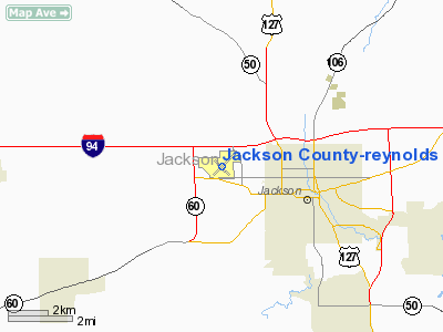
Jackson County - Reynolds Field Airport |
Jackson County Airport
Reynolds Field |
| IATA: JXN – ICAO: KJXN – FAA LID: JXN |
| Summary |
| Airport type |
Public |
| Owner |
Jackson County |
| Serves |
Jackson, Michigan |
| Elevation AMSL |
1,001 ft / 305 m |
| Coordinates |
42°15′38″N 084°27′38″W / 42.26056°N 84.46056°W / 42.26056; -84.46056 |
| Website |
co.jackson.mi.us/... |
| Runways |
| Direction |
Length |
Surface |
| ft |
m |
| 6/24 |
5,349 |
1,630 |
Asphalt |
| 14/32 |
4,000 |
1,219 |
Asphalt |
| Statistics (2008) |
| Aircraft operations |
51,003 |
| Based aircraft |
106 |
| Source: Federal Aviation Administration |
Jackson County Airport (IATA: JXN, ICAO: KJXN, FAA LID: JXN), also known as Reynolds Field, is a county-owned, public-use airport located two nautical miles (3.7 km) west of the central business district of Jackson, in Jackson County, Michigan, United States. It is a class D airport with operating control tower.
The airport is home to the Jackson Community College Flight Center and the annual Hot Air Jubilee (airshow). Until 1984, it had commercial services, operated by Republic Airlines and Simmons Airlines and now serves as a general aviation facility. In 2005 the airport became home to Prestige Aircraft Company LLC, a light sport aircraft manufacturer.
Facilities and aircraft
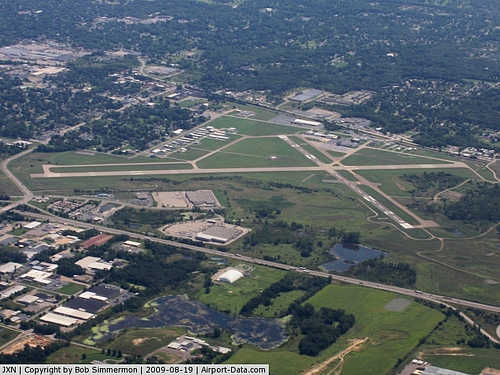
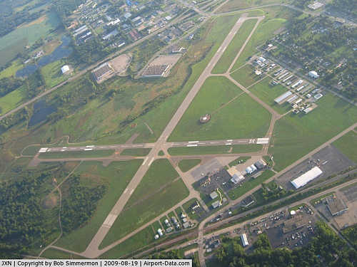
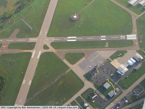
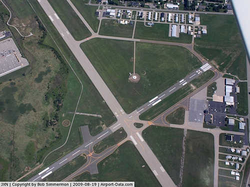
Jackson County-Reynolds Field covers an area of 700 acres (283 ha) at an elevation of 1,001 feet (305 m) above mean sea level. It has two asphalt paved runways: 6/24 is 5,349 by 150 feet (1,630 x 46 m) and 14/32 is 4,000 by 100 feet (1,219 x 30 m).
For the 12-month period ending December 31, 2008, the airport had 51,003 general aviation aircraft operations, an average of 139 per day. At that time there were 106 aircraft based at this airport: 76% single-engine, 13% multi-engine, 4% jet, 3% helicopter and 4% ultralight.
The above content comes from Wikipedia and is published under free licenses – click here to read more.
|
 |
(Click on the photo to enlarge) |
|
 |
(Click on the photo to enlarge) |
|
 |
(Click on the photo to enlarge) |
|
 |
(Click on the photo to enlarge) |
Location & QuickFacts
| FAA Information Effective: | 2008-09-25 |
| Airport Identifier: | JXN |
| Airport Status: | Operational |
| Longitude/Latitude: | 084-27-33.8000W/42-15-35.2000N
-84.459389/42.259778 (Estimated) |
| Elevation: | 1000 ft / 304.80 m (Surveyed) |
| Land: | 700 acres |
| From nearest city: | 2 nautical miles W of Jackson, MI |
| Location: | Jackson County, MI |
| Magnetic Variation: | 05W (1985) |
Owner & Manager
| Ownership: | Publicly owned |
| Owner: | Jackson County |
| Address: | 120 West Michigan Ave, Jackson Co Tower Bld 5th Fl
Jackson, MI 49201 |
| Phone number: | 517-788-4335 |
| Manager: | Kent L Maurer |
| Address: | 3606 Wildwood Ave
Jackson, MI 49202 |
| Phone number: | 517-788-4225 |
Airport Operations and Facilities
| Airport Use: | Open to public |
| Wind indicator: | Yes |
| Segmented Circle: | Yes |
| Control Tower: | Yes |
| Lighting Schedule: | DUSK-DAWN
WHEN ATCT CLSD ACTVT HIRL RY 06/24 & MIRL RY 14/32; VASI RYS 06 & 32; REIL RY 32; MALSR RY 24 - CTAF. |
| Beacon Color: | Clear-Green (lighted land airport) |
| Landing fee charge: | No |
| Sectional chart: | Detroit |
| Region: | AGL - Great Lakes |
| Boundary ARTCC: | ZOB - Cleveland |
| Tie-in FSS: | LAN - Lansing |
| FSS on Airport: | No |
| FSS Toll Free: | 1-800-WX-BRIEF |
| NOTAMs Facility: | JXN (NOTAM-d service avaliable) |
| Federal Agreements: | NGY |
Airport Communications
| CTAF: | 128.475 |
| Unicom: | 122.950 |
Airport Services
| Fuel available: | 100LLA |
| Airframe Repair: | MAJOR |
| Power Plant Repair: | MAJOR |
| Bottled Oxygen: | NONE |
| Bulk Oxygen: | NONE |
Runway Information
Runway 06/24
| Dimension: | 5349 x 150 ft / 1630.4 x 45.7 m |
| Surface: | ASPH, Good Condition |
| Surface Treatment: | Saw-cut or plastic Grooved |
| Weight Limit: | Single wheel: 44000 lbs.
Dual wheel: 60000 lbs.
Dual tandem wheel: 90000 lbs. |
| Edge Lights: | High |
| |
Runway 06 |
Runway 24 |
| Longitude: | 084-28-00.0749W | 084-27-04.8456W |
| Latitude: | 42-15-21.9597N | 42-15-55.2609N |
| Elevation: | 992.00 ft | 989.00 ft |
| Alignment: | 51 | 127 |
| ILS Type: | | ILS
|
| Traffic Pattern: | Left | Left |
| Markings: | Precision instrument, Good Condition | Precision instrument, Good Condition |
| Crossing Height: | 27.00 ft | 0.00 ft |
| Displaced threshold: | 440.00 ft | 0.00 ft |
| VASI: | 4-box on left side | |
| Visual Glide Angle: | 3.00° | 0.00° |
| Approach lights: | | MALSR |
| Runway End Identifier: | | No |
| Centerline Lights: | No | No |
| Touchdown Lights: | No | No |
| Obstruction: | 20 ft rr, 201.0 ft from runway, 465 ft right of centerline
RWY 06 APCH RATIO 25:1 AT DSPLCD THLD, OVR +50 FT TREE, 1250 FT DSTC, 145 FT RT.
6 FT FENCE, RR, BLDG & ROAD. | 42 ft trees, 1628.0 ft from runway, 580 ft right of centerline, 34:1 slope to clear |
|
Runway 14/32
| Dimension: | 3500 x 100 ft / 1066.8 x 30.5 m |
| Surface: | ASPH, Fair Condition |
| Weight Limit: | Single wheel: 30000 lbs.
Dual wheel: 30000 lbs. |
| Edge Lights: | Medium |
| |
Runway 14 |
Runway 32 |
| Longitude: | 084-27-52.7990W | 084-27-18.9361W |
| Latitude: | 42-15-41.9071N | 42-15-18.1866N |
| Elevation: | 986.00 ft | 999.00 ft |
| Alignment: | 127 | 127 |
| Traffic Pattern: | Left | Left |
| Markings: | Non-precision instrument, Poor Condition
RY 14-32 MARKINGS FADED. | Non-precision instrument, Poor Condition |
| Crossing Height: | 0.00 ft | 45.00 ft |
| Displaced threshold: | 0.00 ft | 316.00 ft |
| VASI: | 4-light PAPI on left side | 4-box on left side |
| Visual Glide Angle: | 0.00° | 3.75° |
| Runway End Identifier: | No | Yes |
| Centerline Lights: | No | No |
| Touchdown Lights: | No | No |
| Obstruction: | 81 ft trees, 2000.0 ft from runway, 22:1 slope to clear | 16 ft road, 201.0 ft from runway, 170 ft left of centerline
APCH RATIO 14:1 AT DSPLCD THLD OVER +16 FT ROAD 225 FM DSPLCD THLD 250 L OF CNTRLN.
RWY 32 ROAD O FT FM THR 170 FT L, ALSO 6 FT FENCE, 118 FT L, 0 FT FROM THLD. |
|
Radio Navigation Aids
| ID |
Type |
Name |
Ch |
Freq |
Var |
Dist |
| ADG | NDB | Adrian | | 278.00 | 06W | 29.0 nm |
| TCU | NDB | Tecumseh | | 239.00 | 04W | 29.1 nm |
| OZW | NDB | Howell | | 243.00 | 05W | 30.7 nm |
| BT | NDB | Batol | | 272.00 | 04W | 32.8 nm |
| USE | NDB | Fulton | | 375.00 | 05W | 41.7 nm |
| ANQ | NDB | Angola | | 347.00 | 05W | 46.6 nm |
| BYN | NDB | Bryan | | 260.00 | 04W | 46.9 nm |
| TOL | TACAN | Toledo | 072X | | 05W | 49.7 nm |
| LFD | VOR/DME | Litchfield | 049X | 111.20 | 05W | 18.1 nm |
| AZO | VOR/DME | Kalamazoo | 027X | 109.00 | 01W | 48.7 nm |
| DXO | VOR/DME | Detroit | 081X | 113.40 | 06W | 48.7 nm |
| LAN | VORTAC | Lansing | 045X | 110.80 | 05W | 29.5 nm |
| BTL | VORTAC | Battle Creek | 031X | 109.40 | 02W | 35.4 nm |
| SVM | VORTAC | Salem | 090X | 114.30 | 03W | 39.5 nm |
| CRL | VORTAC | Carleton | 104X | 115.70 | 03W | 46.4 nm |
| PSI | VORTAC | Pontiac | 047X | 111.00 | 03W | 48.9 nm |
| YIP | VOT | Willow Run | | 112.00 | | 41.7 nm |
| DTW | VOT | Detroit Met Wayne | | 109.80 | | 48.7 nm |
Remarks
- DEER & BIRDS ON & INVOF ARPT.
- LOW ALT ACFT OPNS PROHIBITED INVOF PRISON 4 MI NE.
- PRVDD SFC APROPLY MKD; IF USED AT NGT RY APROPLY LGTD INCLUDING EDGE LGTS; CLEAR FAR PART 77 20:1 APCH SFCS TO BOTH RY ENDS; 300 FT & ASSOCD EDGE RY SAFETY AREAS PRVDD; HOLD SHORT LINES PAINTED ON ALL ADJACENT TWYS; AREA BYD EACH THR MKD AS TWYS NOT DSPLCD THRS; THR COORDS & ELEVS PRVDD TO AGL-200.
Images and information placed above are from
http://www.airport-data.com/airport/JXN/
We thank them for the data!
| General Info
|
| Country |
United States
|
| State |
MICHIGAN
|
| FAA ID |
JXN
|
| Latitude |
42-15-35.228N
|
| Longitude |
084-27-33.853W
|
| Elevation |
1001 feet
|
| Near City |
JACKSON
|
We don't guarantee the information is fresh and accurate. The data may
be wrong or outdated.
For more up-to-date information please refer to other sources.
|
|


