 |
|
| Ionia County Airport |
| IATA: none – ICAO: Y70 |
| Summary |
| Airport type |
Public |
| Owner |
Ionia County |
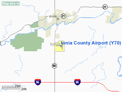
| Location |
Ionia, Michigan |
| Elevation AMSL |
818 ft / 249.3 m |
| Coordinates |
42°56′16″N 85°03′38″W / 42.93778°N 85.06056°W / 42.93778; -85.06056Coordinates: 42°56′16″N 85°03′38″W / 42.93778°N 85.06056°W / 42.93778; -85.06056 |
| Runways |
| Direction |
Length |
Surface |
| ft |
m |
| 9/27 |
4,300 |
1,311 |
Asphalt |
| 7/25 |
4,290 |
1,308 |
Turf |
Ionia County Airport (FAA LID: Y70) is a public airport located 3 mi (5 km) south of Ionia, Michigan. Opened in 1937, the airport is currently owned by Ionia County.
The airport has a 4,300 x 75 ft. E-W primary paved runway and a 4,290 x 340 ft. N-S secondary grass runway. The airport is used for general aviation and has no regularly scheduled commercial flights. Glider activity abounds, with glider instruction available on the field.
Fixed Base Operators
Benz Aviation operates on the field, offering flight instruction, aircraft maintenance, and aerial advertising. Flight instruction consists of a Part 141 flight school as well as glider training.
The School of Missionary Aviation Technology (SMAT) also operates on the field, providing maintenance and flight instruction for aspiring missionary pilot-mechanics.
The above content comes from Wikipedia and is published under free licenses – click here to read more.
Location & QuickFacts
| FAA Information Effective: | 2008-09-25 |
| Airport Identifier: | Y70 |
| Airport Status: | Operational |
| Longitude/Latitude: | 085-03-38.0058W/42-56-16.7911N
-85.060557/42.937998 (Estimated) |
| Elevation: | 818 ft / 249.33 m (Surveyed) |
| Land: | 360 acres |
| From nearest city: | 3 nautical miles S of Ionia, MI |
| Location: | Ionia County, MI |
| Magnetic Variation: | 05W (2000) |
Owner & Manager
| Ownership: | Publicly owned |
| Owner: | Ionia County |
| Address: | Courthouse, 100 W. Main
Ionia, MI 48846 |
| Phone number: | 616-527-5300 |
| Manager: | Anthony Smit |
| Address: | 3147 S State Rd
Ionia, MI 48846 |
| Phone number: | 616-527-9070 |
Airport Operations and Facilities
| Airport Use: | Open to public |
| Wind indicator: | Yes |
| Segmented Circle: | Yes |
| Control Tower: | No |
| Lighting Schedule: | RDO-CTL
ACTVT ROTG BCN - 122.8. |
| Beacon Color: | Clear-Green (lighted land airport) |
| Landing fee charge: | No |
| Sectional chart: | Chicago |
| Region: | AGL - Great Lakes |
| Boundary ARTCC: | ZAU - Chicago |
| Tie-in FSS: | LAN - Lansing |
| FSS on Airport: | No |
| FSS Toll Free: | 1-800-WX-BRIEF |
| NOTAMs Facility: | LAN (NOTAM-d service avaliable) |
| Federal Agreements: | NGY |
Airport Communications
| CTAF: | 122.800 |
| Unicom: | 122.800 |
Airport Services
| Fuel available: | 100LL |
| Airframe Repair: | MAJOR |
| Power Plant Repair: | MAJOR |
| Bottled Oxygen: | NONE |
| Bulk Oxygen: | NONE |
Runway Information
Runway 09/27
| Dimension: | 4300 x 75 ft / 1310.6 x 22.9 m |
| Surface: | ASPH, Good Condition |
| Weight Limit: | Single wheel: 19000 lbs. |
| Edge Lights: | Medium |
| |
Runway 09 |
Runway 27 |
| Longitude: | 085-04-15.9300W | 085-03-18.1080W |
| Latitude: | 42-56-16.6100N | 42-56-16.0190N |
| Elevation: | 815.00 ft | 804.00 ft |
| Alignment: | 91 | 127 |
| Traffic Pattern: | Left | Left |
| Markings: | Non-precision instrument, Fair Condition | Non-precision instrument, Fair Condition |
| Crossing Height: | 25.00 ft | 22.00 ft |
| VASI: | 4-light PAPI on left side | 4-light PAPI on left side |
| Visual Glide Angle: | 3.00° | 3.00° |
| Runway End Identifier: | No
RY 09 REIL OTS INDEFLY. | Yes |
| Touchdown Lights: | No | No |
| Obstruction: | 51 ft tree, 1025.0 ft from runway, 210 ft left of centerline, 16:1 slope to clear | 76 ft trees, 2600.0 ft from runway, 350 ft right of centerline, 31:1 slope to clear |
|
Runway 18/36
| Dimension: | 4290 x 340 ft / 1307.6 x 103.6 m |
| Surface: | TURF, Fair Condition |
| |
Runway 18 |
Runway 36 |
| Longitude: | 085-03-29.7000W | 085-03-28.2430W |
| Latitude: | 42-56-38.5140N | 42-55-56.1470N |
| Elevation: | 805.00 ft | 818.00 ft |
| Alignment: | 127 | 127 |
| Traffic Pattern: | Left | Left |
| Touchdown Lights: | No | No |
| Obstruction: | 75 ft trees, 900.0 ft from runway, 169 ft left of centerline, 12:1 slope to clear | 72 ft tree, 1008.0 ft from runway, 260 ft right of centerline, 14:1 slope to clear
APPR RATIO 20:1 STRAIGHT OUT |
|
Radio Navigation Aids
| ID |
Type |
Name |
Ch |
Freq |
Var |
Dist |
| AMN | NDB | Alma | | 329.00 | 05W | 26.1 nm |
| BT | NDB | Batol | | 272.00 | 04W | 35.1 nm |
| HLM | NDB | Holland | | 233.00 | 03W | 49.1 nm |
| GRR | VOR/DME | Grand Rapids | 106Y | 115.95 | 04W | 21.3 nm |
| MOP | VOR/DME | Mount Pleasant | 043X | 110.60 | 05W | 43.5 nm |
| AZO | VOR/DME | Kalamazoo | 027X | 109.00 | 01W | 47.4 nm |
| HIC | VOR/DME | White Cloud | 123X | 117.60 | 01W | 47.8 nm |
| JXN | VOR/DME | Jackson | 033X | 109.60 | 05W | 48.7 nm |
| LAN | VORTAC | Lansing | 045X | 110.80 | 05W | 20.8 nm |
| BTL | VORTAC | Battle Creek | 031X | 109.40 | 02W | 38.7 nm |
| MKG | VORTAC | Muskegon | 099X | 115.20 | 01W | 45.2 nm |
Remarks
- EXTENSIVE SOARING ACTIVITY.
- ACFT PKD ADJ TO RYS 09/27 & 18/36 DURING GLIDER OPERATIONS.
- GLIDER OPNS CONDUCTED SOUTH OF RY 09/27 & WEST OF RY 18/36; USE FREQ 123.3 IN PRACTICE AREA. GLIDERS USE 122.8 IN TFC PATTERN.
- GCO AVBL ON FREQ 121.725 THRU GRR CD & FLT SVCS.
Images and information placed above are from
http://www.airport-data.com/airport/Y70/
We thank them for the data!
| General Info
|
| Country |
United States
|
| State |
MICHIGAN
|
| FAA ID |
Y70
|
| Latitude |
42-56-16.791N
|
| Longitude |
085-03-37.893W
|
| Elevation |
818 feet
|
| Near City |
IONIA
|
We don't guarantee the information is fresh and accurate. The data may
be wrong or outdated.
For more up-to-date information please refer to other sources.
|
|


