 |
|
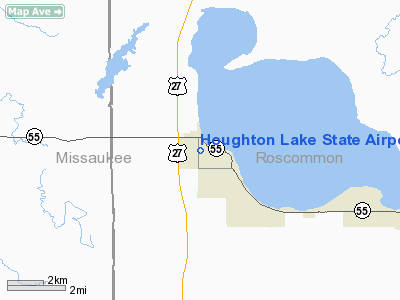
Houghton Lake State Airport |
Location & QuickFacts
| FAA Information Effective: | 2008-09-25 |
| Airport Identifier: | 5Y2 |
| Airport Status: | Operational |
| Longitude/Latitude: | 084-47-30.1030W/44-19-45.0580N
-84.791695/44.329183 (Estimated) |
| Elevation: | 1165 ft / 355.09 m (Surveyed) |
| Land: | 121 acres |
| From nearest city: | 1 nautical miles W of Houghton Lake Heights, MI |
| Location: | Roscommon County, MI |
| Magnetic Variation: | 05W (1985) |
Owner & Manager
| Ownership: | Publicly owned |
| Owner: | State Of Mich Mdot/aero |
| Address: | 2700 E Airport Service Dr
Lansing, MI 48906 |
| Phone number: | 517-335-9681 |
| Manager: | Chris Ambrose |
| Address: | 3940 Benjamin Ne
Grand Rapids, MI 49525 |
| Phone number: | 616-361-2337 |
Airport Operations and Facilities
| Airport Use: | Open to public |
| Wind indicator: | Yes |
| Segmented Circle: | Yes |
| Control Tower: | No |
| Landing fee charge: | No |
| Sectional chart: | Lake Huron |
| Region: | AGL - Great Lakes |
| Boundary ARTCC: | ZMP - Minneapolis |
| Tie-in FSS: | LAN - Lansing |
| FSS on Airport: | No |
| FSS Toll Free: | 1-800-WX-BRIEF |
| NOTAMs Facility: | LAN (NOTAM-d service avaliable) |
Airport Communications
Airport Services
| Airframe Repair: | NONE |
| Power Plant Repair: | NONE |
| Bottled Oxygen: | NONE |
| Bulk Oxygen: | NONE |
Runway Information
Runway 16/34
| Dimension: | 2750 x 104 ft / 838.2 x 31.7 m |
| Surface: | TURF, Fair Condition |
| |
Runway 16 |
Runway 34 |
| Longitude: | 084-47-36.2900W | 084-47-23.9100W |
| Latitude: | 44-19-57.0900N | 44-19-33.0000N |
| Elevation: | 1165.00 ft | 1165.00 ft |
| Traffic Pattern: | Left | Left |
| Displaced threshold: | 550.00 ft | 900.00 ft |
| Obstruction: | 46 ft pole, 375.0 ft from runway, 118 ft right of centerline, 8:1 slope to clear
RWY 16 APCH RATIO AT DSPLCD THLD 20:1. | 122 ft trees, 1220.0 ft from runway, 125 ft left of centerline, 10:1 slope to clear
APCH RATIO AT DSPLCD THLD 20:1. |
|
Radio Navigation Aids
| ID |
Type |
Name |
Ch |
Freq |
Var |
Dist |
| GYG | NDB | Grayling | | 359.00 | 06W | 25.3 nm |
| GDW | NDB | Wiggins | | 209.00 | 04W | 25.5 nm |
| CAD | NDB | Cadillac | | 269.00 | 04W | 27.0 nm |
| BHW | NDB | Hardwood | | 236.00 | 06W | 30.8 nm |
| TV | NDB | Gwenn | | 365.00 | 05W | 36.6 nm |
| CXK | NDB | Clam Lake | | 251.00 | 05W | 39.3 nm |
| CGG | VOR | Grayling | | 109.80 | 06W | 21.4 nm |
| HTL | VOR/DME | Houghton Lake | 053X | 111.60 | 05W | 5.7 nm |
| BXZ | VOR/DME | West Branch | 079X | 113.20 | 06W | 26.7 nm |
| GLR | VOR/DME | Gaylord | 029X | 109.20 | 06W | 41.2 nm |
| MOP | VOR/DME | Mount Pleasant | 043X | 110.60 | 05W | 42.5 nm |
| TVC | VORTAC | Traverse City | 093X | 114.60 | 02W | 38.4 nm |
Remarks
- SNOW REMOVAL IREG - CONFIRM COND WITH AMGR ON 517-422-3913.
- RY 16 HAS 35 FT PLINE ON CNTRLN 315 FT FM THLD, APCH RATIO 9:1, ALSO 51 FT TREE, 445 FT DSTC APCH RATIO 8:1.
- NON-COMPLIANCE FAR 157.
Images and information placed above are from
http://www.airport-data.com/airport/5Y2/
We thank them for the data!
| General Info
|
| Country |
United States
|
| State |
MICHIGAN
|
| FAA ID |
5Y2
|
| Latitude |
44-19-45.058N
|
| Longitude |
084-47-30.103W
|
| Elevation |
1165 feet
|
| Near City |
HOUGHTON LAKE HEIGHTS
|
We don't guarantee the information is fresh and accurate. The data may
be wrong or outdated.
For more up-to-date information please refer to other sources.
|
|


