 |
|
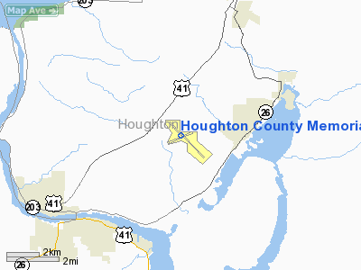
Houghton County Memorial Airport |
| Houghton County Memorial Airport |
| IATA: CMX – ICAO: KCMX – FAA LID: CMX |
| Summary |
| Airport type |
Public |
| Owner |
Houghton County |
| Serves |
Houghton, Hancock, Calumet, Laurium and Lake Linden |
| Location |
Calumet, Michigan |
| Elevation AMSL |
1,095 ft / 334 m |
| Coordinates |
47°10′06″N 088°29′21″W / 47.16833°N 88.48917°W / 47.16833; -88.48917 |
| Website |
www.HoughtonCounty.org |
| Runways |
| Direction |
Length |
Surface |
| ft |
m |
| 13/31 |
6,501 |
1,982 |
Asphalt |
| 7/25 |
5,196 |
1,584 |
Asphalt |
| Statistics (2006) |
| Aircraft operations |
16,054 |
| Based aircraft |
18 |
| Sources: airport website and FAA |
Houghton County Memorial Airport (IATA: CMX, ICAO: KCMX, FAA LID: CMX) is a county-owned public-use airport located in the unincorporated community of Oneco, Michigan in Franklin Township, Houghton County, Michigan, five nautical miles (7 km) south west of the central business district of Calumet, a village in Houghton County, Michigan, United States.
The airport is near the village of Calumet on the Keweenaw Peninsula in northwest of the Upper Peninsula of Michigan. Limited scheduled commercial service is available. In addition, Royale Air Service provides seaplane service to Isle Royale National Park based on traveler demand. Facilities and aircraft
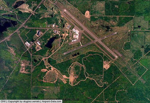
Houghton County Memorial Airport covers an area of 1,996 acres (808 ha) at an elevation of 1,095 feet (334 m) above mean sea level. It has two asphalt paved runways: 13/31 measuring 6,501 by 150 feet (1,982 x 46 m) and 7/25 measuring 5,196 by 100 feet (1,584 x 30 m).
For the 12-month period ending December 31, 2006, the airport had 16,054 aircraft operations, an average of 43 per day: 68% general aviation, 19% scheduled commercial, 13% air taxi and <1% military. At that time there were 18 aircraft based at this airport, all single-engine.
Airlines and destinations
| Airlines |
Destinations |
| United Express operated by SkyWest Airlines |
Chicago-O'Hare |
The above content comes from Wikipedia and is published under free licenses – click here to read more.
|
 |
(Click on the photo to enlarge) |
Location & QuickFacts
| FAA Information Effective: | 2008-09-25 |
| Airport Identifier: | CMX |
| Airport Status: | Operational |
| Longitude/Latitude: | 088-29-20.6190W/47-10-06.3020N
-88.489061/47.168417 (Estimated) |
| Elevation: | 1095 ft / 333.76 m (Surveyed) |
| Land: | 1996 acres |
| From nearest city: | 4 nautical miles NE of Hancock, MI |
| Location: | Houghton County, MI |
| Magnetic Variation: | 02W (1985) |
Owner & Manager
| Ownership: | Publicly owned |
| Owner: | Houghton County |
| Address: | 23810 Airpark Rd Suite 113
Calumet, MI 49913 |
| Phone number: | 906-482-3970 |
| Manager: | Dennis M. Hext |
| Address: | 23810 Airpark Rd Suite 113
Calumet, MI 49913 |
| Phone number: | 906-482-3970 |
Airport Operations and Facilities
| Airport Use: | Open to public |
| Wind indicator: | Yes |
| Segmented Circle: | Yes |
| Control Tower: | No |
| Lighting Schedule: | DUSK-DAWN
ACTVT HIRL RY 13/31, MALSR RY 31, REIL RYS 13 & 25 - CTAF. FOR MIRL RY 07/25 & TWY B RADIO REQ THRU UNICOM. VASI RYS 13 & 25 OPER 24 HRS. |
| Beacon Color: | Clear-Green (lighted land airport) |
| Landing fee charge: | Yes
LNDG FEE WAIVED WITH FUEL PURCHASE FOR MULTI-ENGINE ACFT ONLY. |
| Sectional chart: | Green Bay |
| Region: | AGL - Great Lakes |
| Boundary ARTCC: | ZMP - Minneapolis |
| Tie-in FSS: | GRB - Green Bay |
| FSS on Airport: | No |
| FSS Toll Free: | 1-800-WX-BRIEF |
| NOTAMs Facility: | CMX (NOTAM-d service avaliable) |
| Certification type/date: | I A S 05/1973
ARPT CLSD TO UNSKED ACR OPNS WITH MORE THAN 30 PSGR SEATS EXCP PPR CALL AMGR 906-482-3970. |
| Federal Agreements: | NGY |
Airport Communications
| CTAF: | 122.700 |
| Unicom: | 122.700 |
Airport Services
| Fuel available: | 100LLA |
| Airframe Repair: | MAJOR |
| Power Plant Repair: | MAJOR |
Runway Information
Runway 07/25
| Dimension: | 5196 x 100 ft / 1583.7 x 30.5 m |
| Surface: | ASPH, Fair Condition |
| Surface Treatment: | Porous Friction Course |
| Weight Limit: | Single wheel: 35000 lbs.
Dual wheel: 50000 lbs. |
| Edge Lights: | Medium |
| |
Runway 07 |
Runway 25 |
| Longitude: | 088-29-55.5260W | 088-28-46.3680W |
| Latitude: | 47-09-51.4200N | 47-10-11.5580N |
| Elevation: | 1059.00 ft | 1074.00 ft |
| Alignment: | 67 | 127 |
| Traffic Pattern: | Left | Left |
| Markings: | Non-precision instrument, Good Condition | Non-precision instrument, Good Condition |
| Crossing Height: | 30.00 ft | 41.00 ft |
| VASI: | 2-light PAPI on left side | 4-box on left side |
| Visual Glide Angle: | 3.00° | 3.00° |
| Runway End Identifier: | Yes | Yes |
| Centerline Lights: | No | No |
| Touchdown Lights: | No | No |
| Obstruction: | 55 ft trees, 1660.0 ft from runway, 465 ft left of centerline, 26:1 slope to clear | 51 ft trees, 1630.0 ft from runway, 250 ft left of centerline, 28:1 slope to clear |
|
Runway 13/31
| Dimension: | 6501 x 150 ft / 1981.5 x 45.7 m |
| Surface: | ASPH, Good Condition |
| Surface Treatment: | Saw-cut or plastic Grooved |
| Weight Limit: | Single wheel: 70000 lbs.
Dual wheel: 100000 lbs.
Dual tandem wheel: 185000 lbs. |
| Edge Lights: | High |
| |
Runway 13 |
Runway 31 |
| Longitude: | 088-29-55.9370W | 088-28-44.7810W |
| Latitude: | 47-10-31.1330N | 47-09-49.1600N |
| Elevation: | 1095.00 ft | 1061.00 ft |
| Alignment: | 127 | 127 |
| ILS Type: | | ILS/DME
|
| Traffic Pattern: | Left | Left |
| Markings: | Precision instrument, Good Condition | Precision instrument, Good Condition |
| Crossing Height: | 44.00 ft | 0.00 ft |
| VASI: | 4-box on left side | 4-light PAPI on left side |
| Visual Glide Angle: | 3.00° | 0.00° |
| Approach lights: | | MALSR |
| Runway End Identifier: | Yes | No |
| Centerline Lights: | No | No |
| Touchdown Lights: | No | No |
| Obstruction: | 73 ft trees, 1872.0 ft from runway, 715 ft right of centerline, 22:1 slope to clear | , 50:1 slope to clear |
|
Radio Navigation Aids
| ID |
Type |
Name |
Ch |
Freq |
Var |
Dist |
| CM | NDB | Galey | | 275.00 | 02W | 4.8 nm |
| OGM | NDB | Ontonagon | | 375.00 | 00W | 40.7 nm |
| CMX | VOR/DME | Houghton | 075X | 112.80 | 02W | 0.2 nm |
Remarks
- DEER, GULLS & BEAR ON & INVOF ARPT.
- AIRFIELD GUIDANCE SIGNS SNOW COVERED IN WINTER.
- GA ACFT PARKING PERMITTED IN FRONT OF ACR TRML BLDG. CONTACT UNICOM FOR PERMISSION TO PARK IN FRONT OF TERMINAL.
- PAEW ON ARPT MONITOR CTAF. FREQUENT SNOW REMOVAL OPNS IN PROGRESS VARIOUS TIMES NOV-APR MONITOR CTAF.
- RY 13/31 NSTD SAFETY AREA.
- RY 07/25 NSTD SAFETY AREA.
Images and information placed above are from
http://www.airport-data.com/airport/CMX/
We thank them for the data!
| General Info
|
| Country |
United States
|
| State |
MICHIGAN
|
| FAA ID |
CMX
|
| Latitude |
47-10-06.302N
|
| Longitude |
088-29-20.619W
|
| Elevation |
1095 feet
|
| Near City |
HANCOCK
|
We don't guarantee the information is fresh and accurate. The data may
be wrong or outdated.
For more up-to-date information please refer to other sources.
|
|


