 |
|
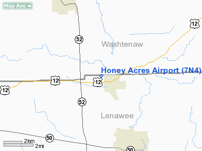
Location & QuickFacts
| FAA Information Effective: | 2008-09-25 |
| Airport Identifier: | 7N4 |
| Airport Status: | Operational |
| Longitude/Latitude: | 083-59-09.7950W/42-04-40.1510N
-83.986054/42.077820 (Estimated) |
| Elevation: | 820 ft / 249.94 m (Estimated) |
| Land: | 60 acres |
| From nearest city: | 1 nautical miles W of Clinton, MI |
| Location: | Lenawee County, MI |
| Magnetic Variation: | 04W (1985) |
Owner & Manager
| Ownership: | Privately owned |
| Owner: | Raymond L. Kussmaul |
| Address: | 12447 Matthews Hwy
Clinton, MI 49236 |
| Phone number: | 517-456-4806 |
| Manager: | Raymond L. Kussmaul |
| Address: | 12447 Matthews Hwy
Clinton, MI 49236 |
| Phone number: | 517-456-4806 |
Airport Operations and Facilities
| Airport Use: | Open to public |
| Wind indicator: | Yes |
| Control Tower: | No |
| Sectional chart: | Detroit |
| Region: | AGL - Great Lakes |
| Boundary ARTCC: | ZOB - Cleveland |
| Tie-in FSS: | LAN - Lansing |
| FSS on Airport: | No |
| FSS Toll Free: | 1-800-WX-BRIEF |
| NOTAMs Facility: | LAN (NOTAM-d service avaliable) |
Airport Communications
Airport Services
Runway Information
Runway 18/36
| Dimension: | 3800 x 90 ft / 1158.2 x 27.4 m |
| Surface: | TURF, Good Condition |
| Edge Lights: | Non-standard lighting system
NSTD LIRL; NSTD COLOR & CONFIG RY 36 FIRST 2300 FT WITH LGTS & NO THLD LGTS. LIRL OTS INDEFLY; NOT FOR PUBLIC USE. |
| |
Runway 18 |
Runway 36 |
| Longitude: | 083-59-10.4000W | 083-59-08.9000W |
| Latitude: | 42-04-58.7000N | 42-04-21.2000N |
| Traffic Pattern: | Left | Left |
| Displaced threshold: | 600.00 ft | 600.00 ft |
| Obstruction: | 35 ft tree, 106 ft left of centerline
RWY 18, APCH RATIO AT DSPLCD THLD 15:1 OVER 35 FT TREE, 106L; ALSO APCH RATIO AT DSPLCD THLD 17:1 OVER 40 FT TREE, 680 FT DSTC, 82 FT R. | 32 ft bldg, 129.0 ft from runway, 55 ft left of centerline, 4:1 slope to clear
RWY 36 APCH RATIO 8:1 AT DSPLCD THLD OVER 80 FT TREE, 714 FT DSTC, 125 L. |
|
Radio Navigation Aids
| ID |
Type |
Name |
Ch |
Freq |
Var |
Dist |
| TCU | NDB | Tecumseh | | 239.00 | 04W | 5.3 nm |
| ADG | NDB | Adrian | | 278.00 | 06W | 13.1 nm |
| USE | NDB | Fulton | | 375.00 | 05W | 28.9 nm |
| OZW | NDB | Howell | | 243.00 | 05W | 33.4 nm |
| RYS | NDB | Grosse Ile | | 419.00 | 06W | 37.2 nm |
| BYN | NDB | Bryan | | 260.00 | 04W | 41.9 nm |
| G | NDB | Golf | | 398.00 | 05W | 43.0 nm |
| DFI | NDB | Defiance | | 246.00 | 05W | 48.9 nm |
| VQ | NDB | Cargl | | 230.00 | 05W | 48.9 nm |
| TOL | TACAN | Toledo | 072X | | 05W | 30.3 nm |
| JXN | VOR/DME | Jackson | 033X | 109.60 | 05W | 23.7 nm |
| DXO | VOR/DME | Detroit | 081X | 113.40 | 06W | 28.8 nm |
| LFD | VOR/DME | Litchfield | 049X | 111.20 | 05W | 34.8 nm |
| VWV | VOR/DME | Waterville | 078X | 113.10 | 02W | 40.7 nm |
| CRL | VORTAC | Carleton | 104X | 115.70 | 03W | 23.7 nm |
| SVM | VORTAC | Salem | 090X | 114.30 | 03W | 26.5 nm |
| PSI | VORTAC | Pontiac | 047X | 111.00 | 03W | 42.5 nm |
| LAN | VORTAC | Lansing | 045X | 110.80 | 05W | 49.8 nm |
| YIP | VOT | Willow Run | | 112.00 | | 22.7 nm |
| DTW | VOT | Detroit Met Wayne | | 109.80 | | 29.1 nm |
| DET | VOT | Detroit City | | 111.60 | | 47.4 nm |
Remarks
- .
- RY 36 HAS A 40 FT CRANE WHICH OCNLLY OPERATES 70 FT W OF RY.
- BUILDING & HGR IN PRIMARY SFC.
- RWY 36, +18 FT PLINE 430 FT FROM THLD MARKED WITH ORANGE BALLS.
- PRVDD CLEAR OBSTACLE FREE ZONE & CLEAR 20:1 APCH SFC.
Images and information placed above are from
http://www.airport-data.com/airport/7N4/
We thank them for the data!
| General Info
|
| Country |
United States
|
| State |
MICHIGAN
|
| FAA ID |
7N4
|
| Latitude |
42-04-40.151N
|
| Longitude |
083-59-09.795W
|
| Elevation |
820 feet
|
| Near City |
CLINTON
|
We don't guarantee the information is fresh and accurate. The data may
be wrong or outdated.
For more up-to-date information please refer to other sources.
|
|


