 |
|
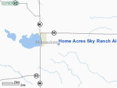
Home Acres Sky Ranch Airport |
|
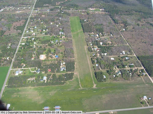 |
(Click on the photo to enlarge) |
Location & QuickFacts
| FAA Information Effective: | 2008-09-25 |
| Airport Identifier: | Y91 |
| Airport Status: | Operational |
| Longitude/Latitude: | 085-10-16.1560W/44-19-13.0360N
-85.171154/44.320288 (Estimated) |
| Elevation: | 1247 ft / 380.09 m (Estimated) |
| Land: | 120 acres |
| From nearest city: | 2 nautical miles E of Lake City, MI |
| Location: | Missaukee County, MI |
| Magnetic Variation: | 05W (1985) |
Owner & Manager
| Ownership: | Privately owned |
| Owner: | Don Kohler |
| Address: | 1816 Larchwood
Troy, MI 48083 |
| Phone number: | 248-524-2355 |
| Manager: | Don Kohler |
| Address: | 1816 Larchwood
Troy, MI 48083 |
| Phone number: | 248-524-2355 |
Airport Operations and Facilities
| Airport Use: | Open to public |
| Wind indicator: | Yes |
| Segmented Circle: | Yes |
| Control Tower: | No |
| Lighting Schedule: | DUSK-DAWN
ACTVT LIRL RYS 09/27 & 18/36 - CTAF. |
| Beacon Color: | Clear-Green (lighted land airport) |
| Landing fee charge: | No |
| Sectional chart: | Green Bay |
| Region: | AGL - Great Lakes |
| Traffic Pattern Alt: | 800 ft |
| Boundary ARTCC: | ZMP - Minneapolis |
| Tie-in FSS: | LAN - Lansing |
| FSS on Airport: | No |
| FSS Toll Free: | 1-800-WX-BRIEF |
| NOTAMs Facility: | LAN (NOTAM-d service avaliable) |
Airport Communications
| CTAF: | 123.000 |
| Unicom: | 123.000 |
Airport Services
| Airframe Repair: | NONE |
| Power Plant Repair: | NONE |
Runway Information
Runway 09/27
| Dimension: | 3830 x 160 ft / 1167.4 x 48.8 m |
| Surface: | TURF, Good Condition |
| Edge Lights: | Low |
| |
Runway 09 |
Runway 27 |
| Longitude: | 085-10-31.9500W | 085-09-38.3100W |
| Latitude: | 44-19-14.1800N | 44-19-14.1800N |
| Elevation: | 1245.00 ft | 1245.00 ft |
| Traffic Pattern: | Left | Left |
| Displaced threshold: | 376.00 ft | 1164.00 ft |
| Runway End Identifier: | No | No |
| Centerline Lights: | No | No |
| Touchdown Lights: | No | No |
| Obstruction: | 15 ft road, 46.0 ft from runway, 3:1 slope to clear
APCH RATIO 20:1 AT DSPLCD THLD BASED ON STRAIGHT OUT OVR +68' TREES, 1360 FT DSTC, OTHERWISE, 14:1 OVR +68 FT TREES; 952 FT FM DSPLCD THLD; 175 FT L. | 45 ft trees, 55.0 ft from runway, 104 ft right of centerline, 1:1 slope to clear
APCH RATIO 20:1 AT DSPLCD THR BASED ON STRAIGHT OUT OVR +65 FT TREES, 1300 FT DSTC, OTHERWISE, 8:1 OVR +70 FT TREES, 300 FT DSTC, 155 FT R. |
|
Runway 18/36
| Dimension: | 2550 x 150 ft / 777.2 x 45.7 m |
| Surface: | TURF, Good Condition |
| Edge Lights: | Low |
| |
Runway 18 |
Runway 36 |
| Longitude: | 085-10-26.1500W | 085-10-26.1500W |
| Latitude: | 44-19-28.7100N | 44-19-03.0300N |
| Elevation: | 1245.00 ft | 1245.00 ft |
| Traffic Pattern: | Left | Left |
| Displaced threshold: | 257.00 ft | 396.00 ft |
| Runway End Identifier: | No | No |
| Centerline Lights: | No | No |
| Touchdown Lights: | No | No |
| Obstruction: | 15 ft road, 43.0 ft from runway, 2:1 slope to clear
APCH RATIO 20:1 AT DSPLCD THLD. | 15 ft road, 36.0 ft from runway, 2:1 slope to clear
APCH RATIO 20:1 AT DSPLCD THLD; +53 FT TREES 1060 FT FM DSPLCD THLD; 140 FT L; 8:1 OVR +57 FT TREES, 456 FT DSTC, 160 FT L. |
|
Radio Navigation Aids
| ID |
Type |
Name |
Ch |
Freq |
Var |
Dist |
| CAD | NDB | Cadillac | | 269.00 | 04W | 10.8 nm |
| TV | NDB | Gwenn | | 365.00 | 05W | 27.2 nm |
| GYG | NDB | Grayling | | 359.00 | 06W | 29.7 nm |
| CXK | NDB | Clam Lake | | 251.00 | 05W | 34.9 nm |
| GDW | NDB | Wiggins | | 209.00 | 04W | 36.7 nm |
| BHW | NDB | Hardwood | | 236.00 | 06W | 47.0 nm |
| CGG | VOR | Grayling | | 109.80 | 06W | 28.8 nm |
| HTL | VOR/DME | Houghton Lake | 053X | 111.60 | 05W | 21.9 nm |
| BXZ | VOR/DME | West Branch | 079X | 113.20 | 06W | 42.8 nm |
| MOP | VOR/DME | Mount Pleasant | 043X | 110.60 | 05W | 45.9 nm |
| GLR | VOR/DME | Gaylord | 029X | 109.20 | 06W | 46.1 nm |
| MBL | VOR/DME | Manistee | 051X | 111.40 | 05W | 46.7 nm |
| TVC | VORTAC | Traverse City | 093X | 114.60 | 02W | 26.5 nm |
Remarks
- NO SNOW REMOVAL.
- DEER & BIRDS ON & INVOF ARPT.
- FOR AIRFRAME & PWR PLANT REPAIRS CALL 231-839-4009
- TALL TREES ALONG BOTH RYS AND AT THE INTERSECTION OF RYS 9/27 AND 18/36 BLOCKING THE VIEW OF INTERSECTING RY.
- CAMPING PERMITTED.
- UNICOM UNMONITORED.
Images and information placed above are from
http://www.airport-data.com/airport/Y91/
We thank them for the data!
| General Info
|
| Country |
United States
|
| State |
MICHIGAN
|
| FAA ID |
Y91
|
| Latitude |
44-19-13.036N
|
| Longitude |
085-10-16.156W
|
| Elevation |
1247 feet
|
| Near City |
LAKE CITY
|
We don't guarantee the information is fresh and accurate. The data may
be wrong or outdated.
For more up-to-date information please refer to other sources.
|
|


