 |
|
| Hiram Cure Airfield |
| IATA: C43 – ICAO: KC43 |
| Summary |
| Airport type |
Public |
| Operator |
Kerry Haynor |
| Location |
Sunfield, Michigan |
| Elevation AMSL |
853 ft / 260 m |
| Coordinates |
42°46′12.115″N 84°57′53.847″W / 42.77003194°N 84.9649575°W / 42.77003194; -84.9649575Coordinates: 42°46′12.115″N 84°57′53.847″W / 42.77003194°N 84.9649575°W / 42.77003194; -84.9649575 |
| Runways |
| Direction |
Length |
Surface |
| ft |
m |
| 9/27 |
2,341 |
714 |
Turf |
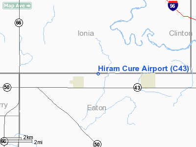
Hiram Cure Airfield (IATA: C43, ICAO: KC43) is a general aviation airport located northeast of Sunfield in Eaton County, Michigan, USA. Facilities
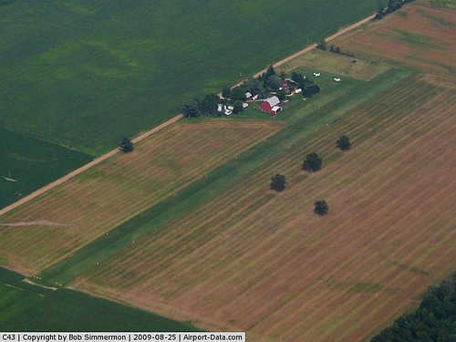
Hiram Cure Airfield has 1 runway. The airport is closed from December through May, and also when snow-covered. It is attended intermittently.
Runways
- Runway 9/27: 2,341 x 100 ft. (714 x 30 m), Surface: Turf
Transit
- The airport is accessible by road from Eaton Hwy, and is located approximately 1 mile north of M-43.
The above content comes from Wikipedia and is published under free licenses – click here to read more.
|
 |
(Click on the photo to enlarge) |
Location & QuickFacts
| FAA Information Effective: | 2008-09-25 |
| Airport Identifier: | C43 |
| Airport Status: | Operational |
| Longitude/Latitude: | 084-57-53.8470W/42-46-12.1150N
-84.964957/42.770032 (Estimated) |
| Elevation: | 853 ft / 259.99 m (Estimated) |
| Land: | 10 acres |
| From nearest city: | 2 nautical miles NE of Sunfield, MI |
| Location: | Eaton County, MI |
| Magnetic Variation: | 05W (1990) |
Owner & Manager
| Ownership: | Privately owned |
| Owner: | Kerry Haynor |
| Address: | 5630 Eaton Hwy
Sunfield, MI 48890 |
| Phone number: | 517-566-8008
FROM 0800-1700, AFT HR 517-566-8616 |
| Manager: | Kerry Haynor |
| Address: | 5630 Eaton Hwy
Sunfield, MI 48890 |
| Phone number: | 517-566-8008
FROM 0800-1700, AFT HR 517-566-8616 |
Airport Operations and Facilities
| Airport Use: | Open to public |
| Wind indicator: | Yes |
| Segmented Circle: | No |
| Control Tower: | No |
| Sectional chart: | Chicago |
| Region: | AGL - Great Lakes |
| Boundary ARTCC: | ZOB - Cleveland |
| Tie-in FSS: | LAN - Lansing |
| FSS Toll Free: | 1-800-WX-BRIEF |
| NOTAMs Facility: | LAN (NOTAM-d service avaliable) |
Airport Communications
Runway Information
Runway 09/27
| Dimension: | 2314 x 100 ft / 705.3 x 30.5 m |
| Surface: | TURF, Good Condition |
| |
Runway 09 |
Runway 27 |
| Traffic Pattern: | Left | Left |
| Obstruction: | 80 ft tree, 1600.0 ft from runway, 261 ft right of centerline, 20:1 slope to clear | , 50:1 slope to clear |
|
Radio Navigation Aids
| ID |
Type |
Name |
Ch |
Freq |
Var |
Dist |
| BT | NDB | Batol | | 272.00 | 04W | 26.4 nm |
| AMN | NDB | Alma | | 329.00 | 05W | 34.2 nm |
| OZW | NDB | Howell | | 243.00 | 05W | 43.9 nm |
| GRR | VOR/DME | Grand Rapids | 106Y | 115.95 | 04W | 23.5 nm |
| JXN | VOR/DME | Jackson | 033X | 109.60 | 05W | 38.0 nm |
| AZO | VOR/DME | Kalamazoo | 027X | 109.00 | 01W | 41.3 nm |
| LFD | VOR/DME | Litchfield | 049X | 111.20 | 05W | 43.4 nm |
| LAN | VORTAC | Lansing | 045X | 110.80 | 05W | 12.2 nm |
| BTL | VORTAC | Battle Creek | 031X | 109.40 | 02W | 30.5 nm |
Remarks
- ARPT CLSD DEC THRU MAR & WHEN SNOW COVERED.
- AMGR LIVES ON PREMISES.
- CROPS ADJ TO RY.
- DEER INVOF OF RY.
- PROVIDED AREA 125 FT EITHER SIDE OF RY CNTRLN IS CLEAR OF OBSTN; BOTH RY ENDS TO BE RELOCATED & CROPS LIMITED TO NO CLOSER THAN 125 FT FROM RY CNTRLN; OBSTN IN RY APCH SLOPE SFC REMOVED/LOWERED OR THR DSPLCD & MARKED TO PROVIDE MINIMUM 20:1 APCH CLNC OVER OBSTN.
Images and information placed above are from
http://www.airport-data.com/airport/C43/
We thank them for the data!
| General Info
|
| Country |
United States
|
| State |
MICHIGAN
|
| FAA ID |
C43
|
| Latitude |
42-46-12.115N
|
| Longitude |
084-57-53.847W
|
| Elevation |
853 feet
|
| Near City |
SUNFIELD
|
We don't guarantee the information is fresh and accurate. The data may
be wrong or outdated.
For more up-to-date information please refer to other sources.
|
|


