 |
|
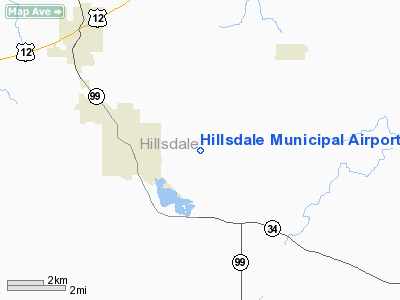
Hillsdale Municipal Airport |
| Hillsdale Municipal Airport |
| IATA: none – ICAO: KJYM – FAA LID: JYM |
| Summary |
| Airport type |
Public |
| Owner |
Tim Vagle |
| Serves |
Hillsdale, Michigan |
| Elevation AMSL |
1,182 ft / 360 m |
| Coordinates |
41°55′17″N 084°35′09″W / 41.92139°N 84.58583°W / 41.92139; -84.58583 |
| Runways |
| Direction |
Length |
Surface |
| ft |
m |
| 10/28 |
4,000 |
1,219 |
Asphalt |
| Statistics (2007) |
| Aircraft operations |
4,400 |
| Based aircraft |
11 |
| Source: Federal Aviation Administration |
Hillsdale Municipal Airport (ICAO: KJYM, FAA LID: JYM) is a public use airport located three nautical miles (6 km) east of the central business district of Hillsdale, in Hillsdale County, Michigan, United States. The airport is accessible by road from Entrance Road and is located near M-99.
Although most U.S. airports use the same three-letter location identifier for the FAA and IATA, this airport is assigned JYM by the FAA but has no designation from the IATA.
Facilities and aircraft
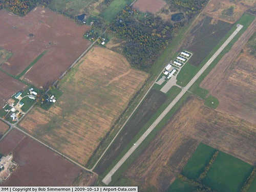
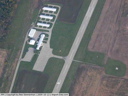
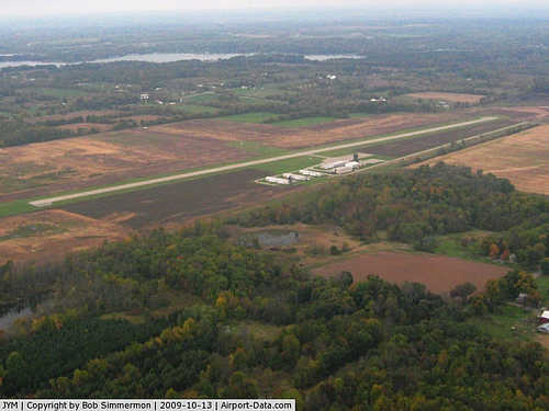
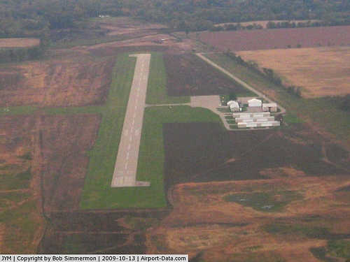
Hillsdale Municipal Airport covers an area of 283 acres (115 ha) at an elevation of 1,182 feet (360 m) above mean sea level. It has one runway designated 10/28 with an asphalt surface measuring 4,000 by 75 feet (1,219 x 23 m).
For the 12-month period ending December 31, 2007, the airport had 4,400 general aviation aircraft operations, an average of 12 per day. At that time there were 11 aircraft based at this airport, all single-engine.
The airport is staffed daily November through March from 8AM until 6PM, and daily April through October from 8AM until 9PM.
The above content comes from Wikipedia and is published under free licenses – click here to read more.
|
 |
(Click on the photo to enlarge) |
|
 |
(Click on the photo to enlarge) |
|
 |
(Click on the photo to enlarge) |
|
 |
(Click on the photo to enlarge) |
Location & QuickFacts
| FAA Information Effective: | 2008-09-25 |
| Airport Identifier: | JYM |
| Airport Status: | Operational |
| Longitude/Latitude: | 084-35-08.7450W/41-55-16.5390N
-84.585763/41.921261 (Estimated) |
| Elevation: | 1182 ft / 360.27 m (Surveyed) |
| Land: | 283 acres |
| From nearest city: | 3 nautical miles E of Hillsdale, MI |
| Location: | Hillsdale County, MI |
| Magnetic Variation: | 05W (1995) |
Owner & Manager
| Ownership: | Publicly owned |
| Owner: | Tim Vagle |
| Address: | 97 N. Broad St
Hillsdale, MI 49242 |
| Phone number: | 517-437-6444 |
| Manager: | James C. Scheibner |
| Address: | Po Box 238, 3998 State Road
Hillsdale, MI 49242 |
| Phone number: | 517-437-4755 |
Airport Operations and Facilities
| Airport Use: | Open to public |
| Wind indicator: | Yes |
| Segmented Circle: | Yes |
| Control Tower: | No |
| Lighting Schedule: | DUSK-DAWN |
| Beacon Color: | Clear-Green (lighted land airport) |
| Landing fee charge: | No |
| Sectional chart: | Detroit |
| Region: | AGL - Great Lakes |
| Boundary ARTCC: | ZOB - Cleveland |
| Tie-in FSS: | LAN - Lansing |
| FSS on Airport: | No |
| FSS Toll Free: | 1-800-WX-BRIEF |
| NOTAMs Facility: | JYM (NOTAM-d service avaliable) |
| Federal Agreements: | NGY |
Airport Communications
| CTAF: | 122.800 |
| Unicom: | 122.800 |
Airport Services
| Fuel available: | 100LLA |
| Airframe Repair: | MAJOR |
| Power Plant Repair: | MAJOR |
Runway Information
Runway 10/28
| Dimension: | 4000 x 75 ft / 1219.2 x 22.9 m |
| Surface: | ASPH, Fair Condition |
| Weight Limit: | Single wheel: 16000 lbs. |
| Edge Lights: | Medium |
| |
Runway 10 |
Runway 28 |
| Longitude: | 084-35-35.1500W | 084-34-42.3400W |
| Latitude: | 41-55-17.7600N | 41-55-15.3170N |
| Elevation: | 1161.00 ft | 1182.00 ft |
| Alignment: | 94 | 127 |
| Traffic Pattern: | Left | Left |
| Markings: | Non-precision instrument, Fair Condition
MARKINGS FADED. | Non-precision instrument, Fair Condition
MARKINGS FADED. |
| Crossing Height: | 0.00 ft | 34.00 ft |
| VASI: | | 4-light PAPI on left side
RY 28 PAPI OTS INDEFLY. |
| Visual Glide Angle: | 0.00° | 3.00° |
| Runway End Identifier: | No | Yes |
| Centerline Lights: | No | No |
| Touchdown Lights: | No | No |
| Obstruction: | 64 ft tree, 1254.0 ft from runway, 105 ft left of centerline, 16:1 slope to clear | 64 ft trees, 1229.0 ft from runway, 16:1 slope to clear |
|
Radio Navigation Aids
| ID |
Type |
Name |
Ch |
Freq |
Var |
Dist |
| ADG | NDB | Adrian | | 278.00 | 06W | 22.9 nm |
| BYN | NDB | Bryan | | 260.00 | 04W | 27.1 nm |
| USE | NDB | Fulton | | 375.00 | 05W | 27.6 nm |
| ANQ | NDB | Angola | | 347.00 | 05W | 28.1 nm |
| TCU | NDB | Tecumseh | | 239.00 | 04W | 32.3 nm |
| DFI | NDB | Defiance | | 246.00 | 05W | 36.0 nm |
| BT | NDB | Batol | | 272.00 | 04W | 37.6 nm |
| IRS | NDB | Sturgis | | 382.00 | 04W | 38.5 nm |
| HAI | NDB | Three Rivers | | 407.00 | 02W | 45.0 nm |
| TOL | TACAN | Toledo | 072X | | 05W | 40.4 nm |
| LFD | VOR/DME | Litchfield | 049X | 111.20 | 05W | 11.7 nm |
| JXN | VOR/DME | Jackson | 033X | 109.60 | 05W | 21.1 nm |
| AZO | VOR/DME | Kalamazoo | 027X | 109.00 | 01W | 47.1 nm |
| BTL | VORTAC | Battle Creek | 031X | 109.40 | 02W | 37.8 nm |
| LAN | VORTAC | Lansing | 045X | 110.80 | 05W | 48.1 nm |
Remarks
- RWY 28, APCH RATIO 20:1 AT THLD.
- RWY 10, APCH RATIO 20:1 AT THLD
Images and information placed above are from
http://www.airport-data.com/airport/JYM/
We thank them for the data!
| General Info
|
| Country |
United States
|
| State |
MICHIGAN
|
| FAA ID |
JYM
|
| Latitude |
41-55-16.539N
|
| Longitude |
084-35-08.745W
|
| Elevation |
1182 feet
|
| Near City |
HILLSDALE
|
We don't guarantee the information is fresh and accurate. The data may
be wrong or outdated.
For more up-to-date information please refer to other sources.
|
|


