 |
|
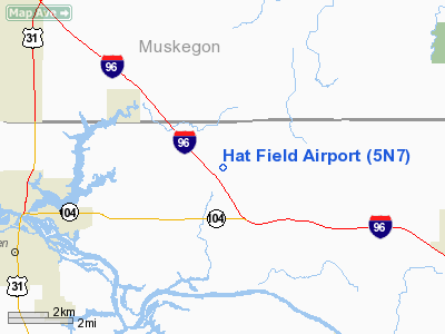
Location & QuickFacts
| FAA Information Effective: | 2008-09-25 |
| Airport Identifier: | 5N7 |
| Airport Status: | Operational |
| Longitude/Latitude: | 086-05-40.6270W/43-05-49.8860N
-86.094619/43.097191 (Estimated) |
| Elevation: | 625 ft / 190.50 m (Estimated) |
| Land: | 110 acres |
| From nearest city: | 2 nautical miles NW of Nunica, MI |
| Location: | Ottawa County, MI |
| Magnetic Variation: | 04W (1995) |
Owner & Manager
| Ownership: | Privately owned |
| Owner: | Bill Hatfield |
| Address: | 18155 120th
Nunica, MI 49448 |
| Phone number: | 616-837-6979 |
| Manager: | Bill Hatfield |
| Address: | 18155 120th
Nunica, MI 49448 |
| Phone number: | 616-837-6979 |
Airport Operations and Facilities
| Airport Use: | Open to public |
| Wind indicator: | Yes |
| Segmented Circle: | No |
| Control Tower: | No |
| Landing fee charge: | No |
| Sectional chart: | Chicago |
| Region: | AGL - Great Lakes |
| Traffic Pattern Alt: | 800 ft |
| Boundary ARTCC: | ZAU - Chicago |
| Tie-in FSS: | LAN - Lansing |
| FSS on Airport: | No |
| FSS Toll Free: | 1-800-WX-BRIEF |
| NOTAMs Facility: | LAN (NOTAM-d service avaliable) |
Airport Communications
Airport Services
| Airframe Repair: | MAJOR |
| Power Plant Repair: | MAJOR |
Runway Information
Runway 08/26
| Dimension: | 3600 x 100 ft / 1097.3 x 30.5 m |
| Surface: | TURF, Good Condition |
| |
Runway 08 |
Runway 26 |
| Traffic Pattern: | Left | Left |
| Displaced threshold: | 600.00 ft | 1200.00 ft |
| Obstruction: | 80 ft trees, 78 ft right of centerline
APCH RATIO 0:1 AT DSPLCD THLD,BASED ON 50 FT TREES, 125 FT R, 0 FT DSTC FROM DSPLCD THLD; 20:1 BASED ON STRAIGHT OUT OVR +70 FT TREES, 1400 FT FM DSPLCT THR, 0 B. | 60 ft tree, 180.0 ft from runway, 3:1 slope to clear
APCH RATIO 20:1 AT DSPLCD THLD OVR 42 FT TREES, 60R, 840 FT FM DSPLCD THLD; 20:1. |
|
Radio Navigation Aids
| ID |
Type |
Name |
Ch |
Freq |
Var |
Dist |
| HLM | NDB | Holland | | 233.00 | 03W | 18.3 nm |
| GRR | VOR/DME | Grand Rapids | 106Y | 115.95 | 04W | 32.2 nm |
| HIC | VOR/DME | White Cloud | 123X | 117.60 | 01W | 33.1 nm |
| PMM | VOR/DME | Pullman | 058X | 112.10 | 00E | 37.9 nm |
| MKG | VORTAC | Muskegon | 099X | 115.20 | 01W | 5.0 nm |
Remarks
- DEER AND BIRDS ON & INVOF ARPT.
- ARPT CLSD NOV THRU MAR.
- PRVDD THE AREA 125 FT OFF EITHER SIDE OF RY & 200 FT OFF RY ENDS IS CLEAR; & OBSTR REMOVESD/LOWERED OR THLD DSPLCD TO PRVD A CLEAR 20:1 APCH; & SPONSOR AGREE TO 800 FT TPA SINCE 1000 FT TPA WILL NOT PRVD 500 FT SEPARATION BETWEEN ACFT.
Images and information placed above are from
http://www.airport-data.com/airport/5N7/
We thank them for the data!
| General Info
|
| Country |
United States
|
| State |
MICHIGAN
|
| FAA ID |
5N7
|
| Latitude |
43-05-49.886N
|
| Longitude |
086-05-40.627W
|
| Elevation |
625 feet
|
| Near City |
NUNICA
|
We don't guarantee the information is fresh and accurate. The data may
be wrong or outdated.
For more up-to-date information please refer to other sources.
|
|


