 |
|
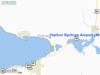
| Harbor Springs Municipal Airport |
| IATA: none – ICAO: KMGN – FAA LID: MGN |
| Summary |
| Airport type |
Public |
| Owner |
Harbor/Petoskey Area Airport Authority |
| Location |
Harbor Springs, Michigan |
| Elevation AMSL |
686 ft / 209 m |
| Coordinates |
45°25′32″N 084°54′48″W / 45.42556°N 84.91333°W / 45.42556; -84.91333 |
| Runways |
| Direction |
Length |
Surface |
| ft |
m |
| 10/28 |
4,157 |
1,267 |
Asphalt |
| Statistics (2005) |
| Aircraft operations |
16,742 |
| Based aircraft |
16 |
| Source: FAA and airport web site |
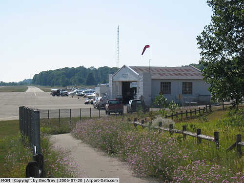
Harbor Springs Municipal Airport (ICAO: KMGN, FAA LID: MGN), also known as Harbor Springs Airport, is a public airport located three miles (5 km) east of the central business district of Harbor Springs, a city in Emmet County, Michigan, United States. This general aviation airport has no scheduled commercial flights.
Although most U.S. airports use the same three-letter location identifier for the FAA and IATA, Harbor Springs Municipal Airport is assigned MGN by the FAA but has no designation from the IATA (which assigned MGN to Baracoa Airport in Magangué, Colombia). The airport's ICAO identifier is KMGN.
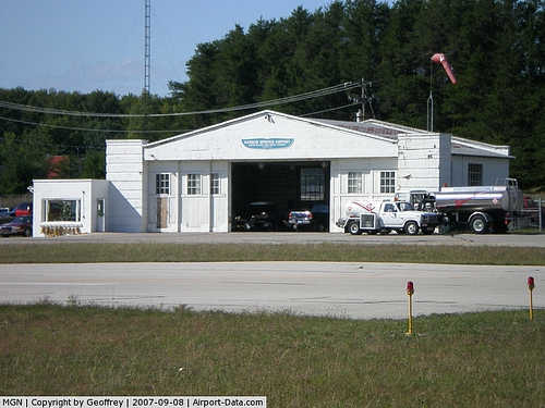
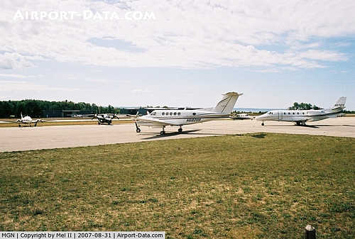
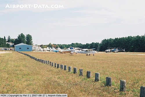
Facilities and aircraft
Harbor Springs Municipal Airport covers an area of 95 acres (38 ha) which contains one asphalt runway (10/28): 4,157 x 75 ft (1,267 x 23 m).
For 12-month period ending 31 December 2005 the airport had 16,742 aircraft operations (100% general aviation), an average of 45 per day. There are 16 aircraft based at this airport: 94% single engine (15) and 6% multi engine (1).
The airport is staffed daily from 8AM until dusk. It is accessible by road from M-119.
The above content comes from Wikipedia and is published under free licenses – click here to read more.
|
 |
(Click on the photo to enlarge) |
|
 |
(Click on the photo to enlarge) |
|
 |
(Click on the photo to enlarge) |
|
 |
(Click on the photo to enlarge) |
Location & QuickFacts
| FAA Information Effective: | 2008-09-25 |
| Airport Identifier: | MGN |
| Airport Status: | Operational |
| Longitude/Latitude: | 084-54-48.1820W/45-25-32.0350N
-84.913384/45.425565 (Estimated) |
| Elevation: | 686 ft / 209.09 m (Surveyed) |
| Land: | 95 acres |
| From nearest city: | 3 nautical miles E of Harbor Springs, MI |
| Location: | Emmet County, MI |
| Magnetic Variation: | 05W (1985) |
Owner & Manager
| Ownership: | Publicly owned |
| Owner: | Harbor/petoskey Area Airport Author |
| Address: | C/o William P. Dohm, P. O. Box 274
Conway, MI 49722-0274 |
| Phone number: | 231-347-2812 |
| Manager: | Mark Zabawa |
| Address: | 8350 M-119
Harbor Springs, MI 49740-9595 |
| Phone number: | 231-347-2812 |
Airport Operations and Facilities
| Airport Use: | Open to public |
| Wind indicator: | Yes |
| Segmented Circle: | No |
| Control Tower: | No |
| Lighting Schedule: | DUSK-DAWN
ACTVT MIRL RY 10/28 - CTAF. |
| Beacon Color: | Clear-Green (lighted land airport) |
| Landing fee charge: | Yes |
| Sectional chart: | Lake Huron |
| Region: | AGL - Great Lakes |
| Boundary ARTCC: | ZMP - Minneapolis |
| Tie-in FSS: | LAN - Lansing |
| FSS on Airport: | No |
| FSS Toll Free: | 1-800-WX-BRIEF |
| NOTAMs Facility: | MGN (NOTAM-d service avaliable) |
| Federal Agreements: | N |
Airport Communications
| CTAF: | 122.800 |
| Unicom: | 122.800 |
Airport Services
Runway Information
Runway 10/28
| Dimension: | 4157 x 75 ft / 1267.1 x 22.9 m |
| Surface: | ASPH, Good Condition |
| Weight Limit: | Single wheel: 22000 lbs.
Dual wheel: 30000 lbs. |
| Edge Lights: | Medium |
| |
Runway 10 |
Runway 28 |
| Longitude: | 084-55-18.1600W | 084-54-20.1900W |
| Latitude: | 45-25-33.8200N | 45-25-29.4900N |
| Elevation: | 677.00 ft | 686.00 ft |
| Alignment: | 96 | 127 |
| Traffic Pattern: | Left | Left |
| Markings: | Non-precision instrument, Fair Condition | Non-precision instrument, Fair Condition |
| Crossing Height: | 25.00 ft | 35.00 ft |
| Displaced threshold: | 445.00 ft | 445.00 ft |
| VASI: | 4-light PAPI on right side | 4-light PAPI on left side |
| Visual Glide Angle: | 3.50° | 4.00° |
| Runway End Identifier: | No | No |
| Centerline Lights: | No | No |
| Touchdown Lights: | No | |
| Obstruction: | 80 ft trees, 201.0 ft from runway, 222 ft left of centerline
APCH RATIO 25:1 TO DSPLCD THLD OVER 41 FT TREE 1025 FT DSTC 110 FT R. BASED ON STRAIGHT OUT.
RWY 10 +4 FT FENCE 0 FT DSTC 48 FT R; +15 FT ROAD 0 FT DSTC 75 FT R.+ 85 FT LIGHTED POLE, 180 FT DSTC, 170 FT L. | 80 ft trees, 201.0 ft from runway, 170 ft right of centerline
APCH RATIO 1:1 TO DSPLCD THLD OVR +80FT TREE; 100 FT DSTC. 250 FT L., 25:1 BASED ON STRAIGHT.
RWY 28 +4 FT FENCE 199 FT DSTC. 70 FT TREES 0 FT DSTC 168 FT L 21 FT RD 250 FT DSTC. 0 FT BOTH |
|
Radio Navigation Aids
| ID |
Type |
Name |
Ch |
Freq |
Var |
Dist |
| BFA | NDB | Boyne Falls | | 263.00 | 06W | 15.6 nm |
| CVX | NDB | Charlevoix | | 392.00 | 05W | 16.8 nm |
| SJX | NDB | St James | | 382.00 | 05W | 31.6 nm |
| CXK | NDB | Clam Lake | | 251.00 | 05W | 34.5 nm |
| GYG | NDB | Grayling | | 359.00 | 06W | 40.8 nm |
| PZQ | NDB | Rogers City | | 215.00 | 07W | 46.1 nm |
| TV | NDB | Gwenn | | 365.00 | 05W | 47.0 nm |
| CGG | VOR | Grayling | | 109.80 | 06W | 45.4 nm |
| GLR | VOR/DME | Gaylord | 029X | 109.20 | 06W | 26.4 nm |
| PLN | VORTAC | Pellston | 055X | 111.80 | 06W | 16.2 nm |
Remarks
- RY 10 HAS 2 LGTD OBSTN POLES 189 FT L; +70 FT TREES ON N SIDE. RY 28 HAS LGTD OBSTN POLES EACH SIDE OF RY.
- RWY 28 +46 FT ANTENNA, 186 FT FM DSPLCD THR, 234 FT R.
- LANDING FEE WAIVED WITH MIN FUEL PURCHASE.
- RY 28 S SIDE +80 FT TREES IN SIDE SLOPE LGTD.
- BIRDS & DEER ON & INVOF ARPT.
- NOISE ABATEMENT PROCEDURES; NO TURBOJET/TURBOFAN ACFT DEPS FM 2300 TO 0700, NO LOW FLIGHT OVR SURROUNDING COMMUNITY, ALL ACFT DEPG TO THE W TURN S OVR THE WATER AS SOON AS PRACTICAL.
Images and information placed above are from
http://www.airport-data.com/airport/MGN/
We thank them for the data!
| General Info
|
| Country |
United States
|
| State |
MICHIGAN
|
| FAA ID |
MGN
|
| Latitude |
45-25-32.035N
|
| Longitude |
084-54-48.182W
|
| Elevation |
686 feet
|
| Near City |
HARBOR SPRINGS
|
We don't guarantee the information is fresh and accurate. The data may
be wrong or outdated.
For more up-to-date information please refer to other sources.
|
|


