 |
|
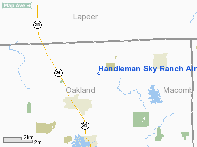
Handleman Sky Ranch Airport |
Location & QuickFacts
| FAA Information Effective: | 2008-09-25 |
| Airport Identifier: | 37MI |
| Airport Status: | Operational |
| Longitude/Latitude: | 083-13-39.7820W/42-51-10.1070N
-83.227717/42.852807 (Estimated) |
| Elevation: | 1150 ft / 350.52 m (Estimated) |
| Land: | 160 acres |
| From nearest city: | 3 nautical miles SW of Oxford, MI |
| Location: | Oakland County, MI |
| Magnetic Variation: | 06W (1985) |
Owner & Manager
| Ownership: | Privately owned |
| Owner: | Philip Handleman |
| Address: | 456 Warren Court
Birmingham, MI 48009 |
| Phone number: | 248-642-5689 |
| Manager: | Philip Handleman |
| Address: | 456 Warren Court
Birmingham, MI 48009 |
| Phone number: | 248-642-5689 |
Airport Operations and Facilities
| Airport Use: | Private |
| Wind indicator: | Yes |
| Segmented Circle: | Yes |
| Control Tower: | No |
| Landing fee charge: | No |
| Sectional chart: | Detroit |
| Region: | AGL - Great Lakes |
| Boundary ARTCC: | ZOB - Cleveland |
| Tie-in FSS: | LAN - Lansing |
| FSS on Airport: | No |
| FSS Toll Free: | 1-800-WX-BRIEF |
Runway Information
Runway 01/19
| Dimension: | 2550 x 150 ft / 777.2 x 45.7 m |
| Surface: | TURF, |
| |
Runway 01 |
Runway 19 |
| Traffic Pattern: | Left | Left |
| Displaced threshold: | 800.00 ft | 800.00 ft |
| Obstruction: | 40 ft trees, 100.0 ft from runway | 40 ft trees, 100.0 ft from runway |
|
Runway 08/26
| Dimension: | 2550 x 150 ft / 777.2 x 45.7 m |
| Surface: | TURF, |
| |
Runway 08 |
Runway 26 |
| Traffic Pattern: | Left | Left |
| Displaced threshold: | 800.00 ft | 800.00 ft |
| Obstruction: | 40 ft trees, 100.0 ft from runway | 40 ft trees, 100.0 ft from runway |
|
Radio Navigation Aids
| ID |
Type |
Name |
Ch |
Freq |
Var |
Dist |
| VQ | NDB | Cargl | | 230.00 | 05W | 32.2 nm |
| OZW | NDB | Howell | | 243.00 | 05W | 36.0 nm |
| QG | NDB | Windsor | | 353.00 | 06W | 36.1 nm |
| G | NDB | Golf | | 398.00 | 05W | 37.5 nm |
| ZR | NDB | Sarnia | | 404.00 | 06W | 44.1 nm |
| HYX | NDB | Browne | | 385.00 | 06W | 44.4 nm |
| RYS | NDB | Grosse Ile | | 419.00 | 06W | 45.3 nm |
| MTC | TACAN | Selfridge | 064X | | 06W | 22.7 nm |
| DXO | VOR/DME | Detroit | 081X | 113.40 | 06W | 38.9 nm |
| YQG | VOR/DME | Windsor | 085X | 113.80 | 06W | 40.3 nm |
| PSI | VORTAC | Pontiac | 047X | 111.00 | 03W | 16.3 nm |
| FNT | VORTAC | Flint | 116X | 116.90 | 06W | 23.9 nm |
| SVM | VORTAC | Salem | 090X | 114.30 | 03W | 31.2 nm |
| ECK | VORTAC | Peck | 087X | 114.00 | 07W | 33.0 nm |
| CRL | VORTAC | Carleton | 104X | 115.70 | 03W | 49.4 nm |
| DET | VOT | Detroit City | | 111.60 | | 28.5 nm |
| DTW | VOT | Detroit Met Wayne | | 109.80 | | 38.1 nm |
| YIP | VOT | Willow Run | | 112.00 | | 39.4 nm |
Remarks
- PROVIDED ALL OBSTACLES WHICH PENETRATE A 20:1 APCH SLOPE TO EACH RWY END ARE RELOCATED/REMOVED/LOWERED OR THE THRESHOLDS ARE DISPLACED AND CLEARLY MARKED SO AS TO PROVIDE AN UNOBSTRUCTED 20:1 SLOPE SURFACE TO EACH RWY END.
Images and information placed above are from
http://www.airport-data.com/airport/37MI/
We thank them for the data!
| General Info
|
| Country |
United States
|
| State |
MICHIGAN
|
| FAA ID |
37MI
|
| Latitude |
42-51-10.107N
|
| Longitude |
083-13-39.782W
|
| Elevation |
1150 feet
|
| Near City |
OXFORD
|
We don't guarantee the information is fresh and accurate. The data may
be wrong or outdated.
For more up-to-date information please refer to other sources.
|
|


