 |
|
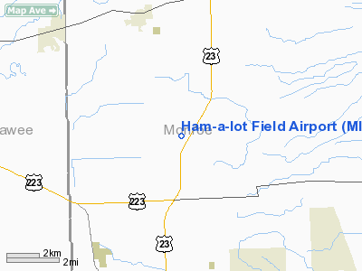
Location & QuickFacts
| FAA Information Effective: | 2008-09-25 |
| Airport Identifier: | MI48 |
| Airport Status: | Operational |
| Longitude/Latitude: | 083-40-59.7750W/41-50-00.1720N
-83.683271/41.833381 (Estimated) |
| Elevation: | 680 ft / 207.26 m (Estimated) |
| Land: | 0 acres |
| From nearest city: | 3 nautical miles S of Petersburg, MI |
| Location: | Monroe County, MI |
| Magnetic Variation: | 05W (1985) |
Owner & Manager
| Ownership: | Privately owned |
| Owner: | William D Wherry |
| Address: | 7423 Bacon Rd
Petersburg, MI 49270 |
| Phone number: | 313-279-1207 |
| Address: |
|
Airport Operations and Facilities
| Airport Use: | Private |
| Wind indicator: | Yes |
| Segmented Circle: | Yes |
| Control Tower: | No |
| Landing fee charge: | No |
| Sectional chart: | Detroit |
| Region: | AGL - Great Lakes |
| Boundary ARTCC: | ZOB - Cleveland |
| Tie-in FSS: | LAN - Lansing |
| FSS on Airport: | No |
| FSS Toll Free: | 1-800-WX-BRIEF |
Runway Information
Runway 07/25
| Dimension: | 2400 x 100 ft / 731.5 x 30.5 m |
| Surface: | TURF, |
| |
Runway 07 |
Runway 25 |
| Traffic Pattern: | Left | Left |
| Obstruction: | 20 ft pline | |
|
Radio Navigation Aids
| ID |
Type |
Name |
Ch |
Freq |
Var |
Dist |
| TCU | NDB | Tecumseh | | 239.00 | 04W | 15.0 nm |
| ADG | NDB | Adrian | | 278.00 | 06W | 17.8 nm |
| USE | NDB | Fulton | | 375.00 | 05W | 24.3 nm |
| RYS | NDB | Grosse Ile | | 419.00 | 06W | 28.6 nm |
| G | NDB | Golf | | 398.00 | 05W | 37.6 nm |
| FZI | NDB | Fostoria | | 379.00 | 05W | 40.8 nm |
| BYN | NDB | Bryan | | 260.00 | 04W | 41.1 nm |
| PCW | NDB | Port Clinton | | 423.00 | 06W | 41.2 nm |
| DFI | NDB | Defiance | | 246.00 | 05W | 44.9 nm |
| VQ | NDB | Cargl | | 230.00 | 05W | 45.2 nm |
| PT | NDB | Pelee Island | | 283.00 | 05W | 45.5 nm |
| QG | NDB | Windsor | | 353.00 | 06W | 46.4 nm |
| BNR | NDB | Benton Ridge | | 334.00 | 05W | 48.8 nm |
| TII | NDB | Tiffin | | 269.00 | 05W | 49.1 nm |
| PDR | NDB | Ottawa | | 233.00 | 05W | 50.0 nm |
| OZW | NDB | Howell | | 243.00 | 05W | 50.0 nm |
| TOL | TACAN | Toledo | 072X | | 05W | 15.3 nm |
| MAH | VOR | Marathon | | 114.90 | 05W | 49.2 nm |
| VWV | VOR/DME | Waterville | 078X | 113.10 | 02W | 23.0 nm |
| DXO | VOR/DME | Detroit | 081X | 113.40 | 06W | 26.8 nm |
| JXN | VOR/DME | Jackson | 033X | 109.60 | 05W | 43.0 nm |
| YQG | VOR/DME | Windsor | 085X | 113.80 | 06W | 45.6 nm |
| CRL | VORTAC | Carleton | 104X | 115.70 | 03W | 16.4 nm |
| SVM | VORTAC | Salem | 090X | 114.30 | 03W | 34.8 nm |
| YIP | VOT | Willow Run | | 112.00 | | 25.1 nm |
| DTW | VOT | Detroit Met Wayne | | 109.80 | | 27.6 nm |
| DET | VOT | Detroit City | | 111.60 | | 45.4 nm |
Images and information placed above are from
http://www.airport-data.com/airport/MI48/
We thank them for the data!
| General Info
|
| Country |
United States
|
| State |
MICHIGAN
|
| FAA ID |
MI48
|
| Latitude |
41-50-00.172N
|
| Longitude |
083-40-59.775W
|
| Elevation |
680 feet
|
| Near City |
PETERSBURG
|
We don't guarantee the information is fresh and accurate. The data may
be wrong or outdated.
For more up-to-date information please refer to other sources.
|
|


