|
|
Grosse Ile Municipal Airport |
Coordinates: 42°05′57″N 083°09′41″W / 42.09917°N 83.16139°W / 42.09917; -83.16139
| Grosse Ile Municipal Airport |
| IATA: none – ICAO: KONZ – FAA LID: ONZ |
| Summary |
| Airport type |
Public |
| Owner |
Township of Grosse Ile |
| Serves |
Grosse Ile Township, Michigan |
| Elevation AMSL |
591 ft / 180 m |
| Runways |
| Direction |
Length |
Surface |
| ft |
m |
| 4/22 |
4,846 |
1,477 |
Concrete |
| 17/35 |
4,425 |
1,349 |
Concrete |
| Statistics (2006) |
| Aircraft operations |
52,820 |
| Based aircraft |
88 |
| Source: Federal Aviation Administration |
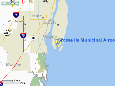
Grosse Ile Municipal Airport (ICAO: KONZ, FAA LID: ONZ) is a public airport located two miles (3 km) south of the central business district of Grosse Ile, in Wayne County, Michigan, United States. It is owned by the Township of Grosse Ile.
Although most U.S. airports use the same three-letter location identifier for the FAA and IATA, Grosse Ile Municipal Airport is assigned ONZ by the FAA but has no designation from the IATA. History
In 1929, the U.S. Navy Air Station opened as a training school, seaplane base and dirigible hangar. The base operated until 1969, when it was closed and turned over to the Township in 1971 for operation as a general aviation airport. A memorial garden sits directly behind Township Hall, the former Hangar One, to honor all the men and women who served in the armed forces at the Naval Air Station Grosse Ile.
The airport taxiways are now going through a major renovation that should be completed next year.
Facilities and aircraft
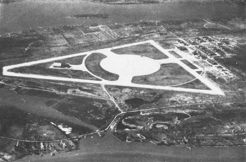
 | |
Aerial view of Naval Air Station Grosse Ile in the 1940s |
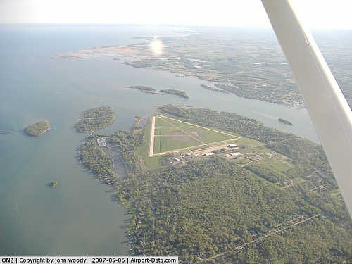
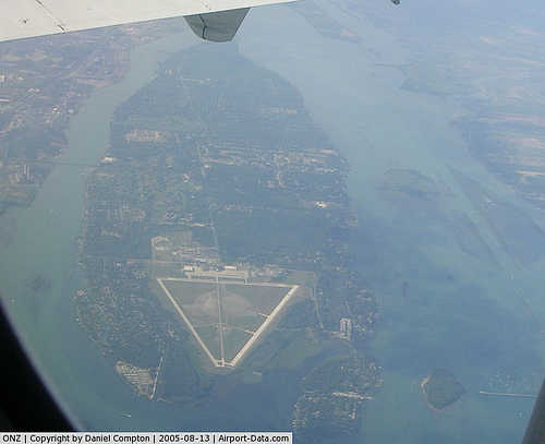
Grosse Ile Municipal Airport covers an area of 607 acres (246 ha) which contains two concrete paved runways: 4/22 measuring 4,846 x 100 ft (1,477 x 30 m) and 17/35 measuring 4,425 x 75 ft (1,349 x 23 m). For the 12-month period ending December 31, 2006, the airport had 52,820 general aviation aircraft operations, an average of 144 per day.
The airport is accessible by taking Jefferson Street to the Grosse Ile Parkway and turning right onto Meridian Road. Continue on Meridian Road and turn right onto Groh Road. Watch for the Township Hall sign on the left (about 200-250 yards), which marks the entrance drive to the parking lot. The airport offices are on the second floor.
The above content comes from Wikipedia and is published under free licenses – click here to read more.
|
 |
(Click on the photo to enlarge) |
|
 |
(Click on the photo to enlarge) |
|
 |
(Click on the photo to enlarge) |
Location & QuickFacts
| FAA Information Effective: | 2008-09-25 |
| Airport Identifier: | ONZ |
| Airport Status: | Operational |
| Longitude/Latitude: | 083-09-41.2870W/42-05-56.6830N
-83.161469/42.099079 (Estimated) |
| Elevation: | 591 ft / 180.14 m (Surveyed) |
| Land: | 607 acres |
| From nearest city: | 2 nautical miles S of Detroit/grosse Ile, MI |
| Location: | Wayne County, MI |
| Magnetic Variation: | 04W (1975) |
Owner & Manager
| Ownership: | Publicly owned |
| Owner: | Township Of Grosse Ile |
| Address: | 9601 Groh Road, P.o. Box 129
Grosse Ile, MI 48138 |
| Phone number: | 734-675-0155 |
| Manager: | Derek Thiel |
| Address: | 9601 Groh Road, P.o. Box 129
Grosse Ile, MI 48138 |
| Phone number: | 734-675-0155 |
Airport Operations and Facilities
| Airport Use: | Open to public |
| Wind indicator: | Yes |
| Segmented Circle: | Yes |
| Control Tower: | No |
| Lighting Schedule: | DUSK-DAWN
MIRL RYS 04/22 & 17/35 PRESET LOW INTST DUSK-2300; TO INCR INTST & ACTVT AFT 2300 - CTAF. ACTVT REIL RY 04 & PAPI RYS 17, 35, 22 & 04 - CTAF. |
| Beacon Color: | Clear-Green (lighted land airport) |
| Landing fee charge: | No |
| Sectional chart: | Detroit |
| Region: | AGL - Great Lakes |
| Traffic Pattern Alt: | 1000 ft |
| Boundary ARTCC: | ZOB - Cleveland |
| Tie-in FSS: | LAN - Lansing |
| FSS on Airport: | No |
| FSS Toll Free: | 1-800-WX-BRIEF |
| NOTAMs Facility: | ONZ (NOTAM-d service avaliable) |
| Federal Agreements: | NGPY |
Airport Communications
| CTAF: | 123.000 |
| Unicom: | 123.000 |
Airport Services
| Fuel available: | 100LLA |
| Airframe Repair: | MAJOR |
| Power Plant Repair: | MAJOR |
| Bottled Oxygen: | NONE |
| Bulk Oxygen: | NONE |
Runway Information
Runway 04/22
| Dimension: | 4846 x 100 ft / 1477.1 x 30.5 m |
| Surface: | CONC, Good Condition |
| Weight Limit: | Single wheel: 66000 lbs.
Dual wheel: 83000 lbs.
Dual tandem wheel: 105000 lbs. |
| Edge Lights: | Medium |
| |
Runway 04 |
Runway 22 |
| Longitude: | 083-09-44.5590W | 083-09-12.0910W |
| Latitude: | 42-05-36.0730N | 42-06-17.3900N |
| Elevation: | 577.00 ft | 590.00 ft |
| Alignment: | 30 | 127 |
| Traffic Pattern: | Right | Left |
| Markings: | Non-precision instrument, Fair Condition
MARKINGS FADED. | Non-precision instrument, Good Condition
MARKINGS FADED. |
| Crossing Height: | 38.00 ft | 38.00 ft |
| Displaced threshold: | 0.00 ft | 428.00 ft |
| VASI: | 4-light PAPI on left side
PAPI OTS INDEFLY. | 4-light PAPI on left side |
| Visual Glide Angle: | 3.00° | 3.00° |
| Runway End Identifier: | Yes
REIL OTS INDEFLY. | Yes |
| Centerline Lights: | No | No |
| Touchdown Lights: | No | No |
| Obstruction: | , 50:1 slope to clear | 73 ft trees, 1190.0 ft from runway, 13:1 slope to clear
APCH RATIO 22:1 AT DSPLCD THLD. |
|
Runway 17/35
| Dimension: | 4425 x 75 ft / 1348.7 x 22.9 m |
| Surface: | CONC, Good Condition |
| Weight Limit: | Single wheel: 40000 lbs.
Dual wheel: 55000 lbs.
Dual tandem wheel: 90000 lbs. |
| Edge Lights: | Medium |
| |
Runway 17 |
Runway 35 |
| Longitude: | 083-10-02.1910W | 083-09-48.7750W |
| Latitude: | 42-06-17.9090N | 42-05-35.3520N |
| Elevation: | 581.00 ft | 579.00 ft |
| Alignment: | 127 | 127 |
| Traffic Pattern: | Left | Right |
| Markings: | Basic, Fair Condition | Basic, Fair Condition |
| Crossing Height: | 20.00 ft | 20.00 ft |
| Displaced threshold: | 675.00 ft | 0.00 ft |
| VASI: | 4-light PAPI on left side | 4-light PAPI on left side |
| Visual Glide Angle: | 3.00° | 3.00° |
| Runway End Identifier: | No | No |
| Centerline Lights: | No | No |
| Touchdown Lights: | No | No |
| Obstruction: | 75 ft trees, 1240.0 ft from runway, 160 ft right of centerline, 13:1 slope to clear
RWY 17 APCH RATIO 25:1 AT DSPLCD THLD. | 4 ft fence, 320.0 ft from runway, 30:1 slope to clear |
|
Radio Navigation Aids
| ID |
Type |
Name |
Ch |
Freq |
Var |
Dist |
| RYS | NDB | Grosse Ile | | 419.00 | 06W | 0.4 nm |
| G | NDB | Golf | | 398.00 | 05W | 10.1 nm |
| VQ | NDB | Cargl | | 230.00 | 05W | 18.0 nm |
| QG | NDB | Windsor | | 353.00 | 06W | 18.3 nm |
| PT | NDB | Pelee Island | | 283.00 | 05W | 29.2 nm |
| TCU | NDB | Tecumseh | | 239.00 | 04W | 32.3 nm |
| PCW | NDB | Port Clinton | | 423.00 | 06W | 37.3 nm |
| ADG | NDB | Adrian | | 278.00 | 06W | 43.2 nm |
| OZW | NDB | Howell | | 243.00 | 05W | 48.8 nm |
| 4L | NDB | Chatham | | 236.00 | 06W | 49.9 nm |
| MTC | TACAN | Selfridge | 064X | | 06W | 34.2 nm |
| TOL | TACAN | Toledo | 072X | | 05W | 41.7 nm |
| DXO | VOR/DME | Detroit | 081X | 113.40 | 06W | 11.4 nm |
| YQG | VOR/DME | Windsor | 085X | 113.80 | 06W | 17.4 nm |
| VWV | VOR/DME | Waterville | 078X | 113.10 | 02W | 44.4 nm |
| SKY | VOR/DME | Sandusky | 029X | 109.20 | 04W | 46.0 nm |
| CRL | VORTAC | Carleton | 104X | 115.70 | 03W | 13.6 nm |
| SVM | VORTAC | Salem | 090X | 114.30 | 03W | 26.8 nm |
| PSI | VORTAC | Pontiac | 047X | 111.00 | 03W | 39.7 nm |
| DTW | VOT | Detroit Met Wayne | | 109.80 | | 11.9 nm |
| YIP | VOT | Willow Run | | 112.00 | | 18.0 nm |
| DET | VOT | Detroit City | | 111.60 | | 19.5 nm |
Remarks
- BIRDS & DEER ON & INVOF ARPT.
- GCO AVBL ON FREQ 121.725 THRU DTW CLEARANCE DELIVERY AND LAN AFSS.
- ULTRALIGHT & POWERED PARACHUTE ACTIVITY INVOF ARPT.
- GCO AVBL ON FREQ 121.725 THRU DTW CLEARANCE DELIVERY AND LAN AFSS.
Images and information placed above are from
http://www.airport-data.com/airport/ONZ/
We thank them for the data!
| General Info
|
| Country |
United States
|
| State |
MICHIGAN
|
| FAA ID |
ONZ
|
| Latitude |
42-05-54.977N
|
| Longitude |
083-09-39.811W
|
| Elevation |
591 feet
|
| Near City |
DETROIT/GROSSE ILE
|
We don't guarantee the information is fresh and accurate. The data may
be wrong or outdated.
For more up-to-date information please refer to other sources.
|
|