 |
|
| Grayling AAF |
| IATA: none – ICAO: KGOV – FAA LID: GOV |
| Summary |
| Airport type |
Public / Military |
| Owner |
United States Army |
| Location |
Grayling, Michigan |
| Elevation AMSL |
1,158 ft / 353 m |
| Coordinates |
44°40′49″N 084°43′44″W / 44.68028°N 84.72889°W / 44.68028; -84.72889 |
| Runways |
| Direction |
Length |
Surface |
| ft |
m |
| 5/23 |
5,000 |
1,524 |
Concrete |
| 14/32 |
5,000 |
1,524 |
Asphalt |
| Statistics (2008) |
| Aircraft operations |
4,691 |
| Source: Federal Aviation Administration |
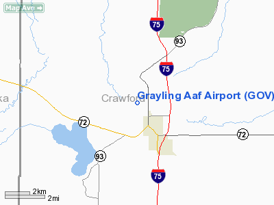
Grayling Army Airfield (ICAO: KGOV, FAA LID: GOV) is a public/military use airport located one nautical mile (1.85 km) northwest of the central business district of Grayling, in Crawford County, Michigan, United States. It is owned by United States Army. The airfield is located 7 miles (11 km) northeast of the main cantonment area of Camp Grayling.
Grayling AAF covers an area of 923 acres (374 ha) at an elevation of 1,158 feet (353 m) above mean sea level. For the 12-month period ending December 31, 2008, the airport had 4,691 aircraft operations, an average of 10 per day: 63% general aviation and 37% military.
Although most U.S. airports use the same three-letter location identifier for the FAA and IATA, this airport is assigned GOV by the FAA but has no designation from the IATA (which assigned GOV to Gove Airport in Australia). Facilities
The airport is staffed from dawn until dusk. The 29,000-square-foot (2,700 m) parking area can accommodate fixed-wing aircraft with parking for 100 helicopters, 50 with cement pads with a total of 70 tie downs. The control tower was recently upgraded to a STVS (Small Tower Voice Switch) system with positions in three different locations. There is an 800-square-foot (74 m) operations building which includes an operations center, flight planning room, safety office, commander's office, and a weather room. Additionally, the airfield contains a 6,400-square-foot (590 m) maintenance hangar, crash rescue barn and NAVAIDS which include TVOR, NDB, VASI and REIL.
Runways
The airfield consists of two 5000x150-foot runways with 1,200-foot (370 m) overrun and 50-foot (15 m) wide connecting taxiways.
- Runway 5/23: 5,000 x 150 ft (1,524 x 46 m), Surface: Concrete
- Runway 14/32: 5,000 x 150 ft (1,524 x 46 m), Surface: Asphalt
Runway 5/23 and taxiways A/D/E are closed during the winter months, since there is no snow removal on these surfaces.
Transit
- The airport is accessible by road from M-93, and is close to M-72 and I-75.
The above content comes from Wikipedia and is published under free licenses – click here to read more.
Location & QuickFacts
| FAA Information Effective: | 2008-09-25 |
| Airport Identifier: | GOV |
| Airport Status: | Operational |
| Longitude/Latitude: | 084-43-43.9060W/44-40-49.1530N
-84.728863/44.680320 (Estimated) |
| Elevation: | 1158 ft / 352.96 m (Surveyed) |
| Land: | 923 acres |
| From nearest city: | 1 nautical miles NW of Grayling, MI |
| Location: | Crawford County, MI |
| Magnetic Variation: | 06W (2000) |
Owner & Manager
| Ownership: | Army owned |
| Owner: | Us Army |
| Address: | Grayling Army Airfield
Grayling, MI 49739 |
| Phone number: | 989-348-4038 |
| Manager: | Dennis Palmer |
| Address: | Bldg 1101, Grayling Army Airfield
Grayling, MI 49739 |
| Phone number: | 989-348-4038 |
Airport Operations and Facilities
| Airport Use: | Open to public |
| Wind indicator: | Yes |
| Segmented Circle: | Yes |
| Control Tower: | Yes |
| Lighting Schedule: | DUSK-DAWN
ACTVT MIRL RYS 14/32 & 5/23, REIL RYS 05, 23, 14 & 32 & PAPI RYS 05, 23, 14 & 32 - CTAF. |
| Beacon Color: | Clear-Green (lighted land airport) |
| Landing fee charge: | No |
| Sectional chart: | Lake Huron |
| Region: | AGL - Great Lakes |
| Traffic Pattern Alt: | 1042 ft |
| Boundary ARTCC: | ZMP - Minneapolis |
| Tie-in FSS: | LAN - Lansing |
| FSS on Airport: | No |
| FSS Toll Free: | 1-800-WX-BRIEF |
| NOTAMs Facility: | GOV (NOTAM-d service avaliable) |
| Federal Agreements: | N |
Airport Communications
| CTAF: | 122.800 |
| Unicom: | 122.800 |
Airport Services
| Bottled Oxygen: | NONE |
| Bulk Oxygen: | NONE |
Runway Information
Runway 05/23
| Dimension: | 5000 x 150 ft / 1524.0 x 45.7 m |
| Surface: | CONC, Fair Condition |
| Weight Limit: | Dual wheel: 12000 lbs. |
| Edge Lights: | Medium |
| |
Runway 05 |
Runway 23 |
| Longitude: | 084-44-05.7790W | 084-43-15.9080W |
| Latitude: | 44-40-45.0300N | 44-41-19.2550N |
| Elevation: | 1151.00 ft | 1158.00 ft |
| Alignment: | 46 | 127 |
| Traffic Pattern: | Left | Left |
| Markings: | Non-precision instrument, Fair Condition | Non-precision instrument, Fair Condition |
| Crossing Height: | 41.00 ft | 30.00 ft |
| VASI: | 4-light PAPI on left side | 4-light PAPI on left side |
| Visual Glide Angle: | 4.00° | 3.00° |
| Runway End Identifier: | Yes | Yes |
| Centerline Lights: | No | No |
| Touchdown Lights: | No | No |
| Obstruction: | 58 ft trees, 1360.0 ft from runway, 20:1 slope to clear | 52 ft trees, 1240.0 ft from runway, 230 ft left of centerline, 20:1 slope to clear |
|
Runway 14/32
| Dimension: | 5000 x 150 ft / 1524.0 x 45.7 m |
| Surface: | ASPH, Good Condition |
| Weight Limit: | Single wheel: 35000 lbs.
Dual wheel: 45000 lbs.
Dual tandem wheel: 80000 lbs. |
| Edge Lights: | Medium |
| |
Runway 14 |
Runway 32 |
| Longitude: | 084-44-10.9250W | 084-43-22.9530W |
| Latitude: | 44-40-53.9680N | 44-40-18.4130N |
| Elevation: | 1153.00 ft | 1149.00 ft |
| Alignment: | 127 | 127 |
| Traffic Pattern: | Left | Left |
| Markings: | Non-precision instrument, Fair Condition
RY 14/32 MARKINGS FADED. | Non-precision instrument, Fair Condition |
| Crossing Height: | 30.00 ft | 34.00 ft |
| Displaced threshold: | 0.00 ft | 300.00 ft |
| VASI: | 4-light PAPI on left side | 4-light PAPI on left side |
| Visual Glide Angle: | 3.00° | 3.50° |
| Runway End Identifier: | Yes | Yes |
| Centerline Lights: | No | No |
| Touchdown Lights: | No | No |
| Obstruction: | 62 ft tree, 1750.0 ft from runway, 180 ft right of centerline, 25:1 slope to clear | 54 ft trees, 956.0 ft from runway, 200 ft right of centerline, 14:1 slope to clear
APCH RATIO 23:1 TO DSPLCD THLD. |
|
Radio Navigation Aids
| ID |
Type |
Name |
Ch |
Freq |
Var |
Dist |
| GYG | NDB | Grayling | | 359.00 | 06W | 6.0 nm |
| CXK | NDB | Clam Lake | | 251.00 | 05W | 25.5 nm |
| TV | NDB | Gwenn | | 365.00 | 05W | 30.1 nm |
| BFA | NDB | Boyne Falls | | 263.00 | 06W | 30.4 nm |
| BHW | NDB | Hardwood | | 236.00 | 06W | 37.9 nm |
| CAD | NDB | Cadillac | | 269.00 | 04W | 38.2 nm |
| CVX | NDB | Charlevoix | | 392.00 | 05W | 43.9 nm |
| GDW | NDB | Wiggins | | 209.00 | 04W | 44.1 nm |
| HTL | VOR/DME | Houghton Lake | 053X | 111.60 | 05W | 19.5 nm |
| GLR | VOR/DME | Gaylord | 029X | 109.20 | 06W | 20.0 nm |
| BXZ | VOR/DME | West Branch | 079X | 113.20 | 06W | 35.2 nm |
| TVC | VORTAC | Traverse City | 093X | 114.60 | 02W | 35.1 nm |
Remarks
- BIRDS & DEER ON & INVOF ARPT.
- EXTENSIVE MILITARY HELICOPTER TFC JUN THRU AUG.
- RY 05/23 & TWYS A/D/E CLSD WINTER MONTHS; NO SNOW REMOVAL.
Images and information placed above are from
http://www.airport-data.com/airport/GOV/
We thank them for the data!
| General Info
|
| Country |
United States
|
| State |
MICHIGAN
|
| FAA ID |
GOV
|
| Latitude |
44-40-49.153N
|
| Longitude |
084-43-43.906W
|
| Elevation |
1158 feet
|
| Near City |
GRAYLING
|
We don't guarantee the information is fresh and accurate. The data may
be wrong or outdated.
For more up-to-date information please refer to other sources.
|
|


