 |
|
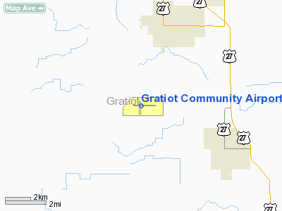
Gratiot Community Airport |
| Gratiot Community Airport |
| IATA: AMN – ICAO: KAMN |
| Summary |
| Airport type |
Public |
| Operator |
City of Alma |
| Location |
Alma, Michigan |
| Elevation AMSL |
754 ft / 229.8 m |
| Coordinates |
43°19′19.713″N 84°41′16.617″W / 43.3221425°N 84.68794917°W / 43.3221425; -84.68794917Coordinates: 43°19′19.713″N 84°41′16.617″W / 43.3221425°N 84.68794917°W / 43.3221425; -84.68794917 |
| Runways |
| Direction |
Length |
Surface |
| ft |
m |
| 9/27 |
5,000 |
1,524 |
Asphalt |
| 18/36 |
3,200 |
976 |
Asphalt |
Gratiot Community Airport (IATA: AMN, ICAO: KAMN) is a public airport located 3 miles (5 km) southwest of Alma in Gratiot County, Michigan, USA. Facilities
The airport is staffed between 8am and 6pm.
Runways
- Runway 9/27: 5,000 x 75 ft. (1,524 x 23 m), Surface: Asphalt
- Runway 18/36: 3,200 x 75 ft. (976 x 23 m), Surface: Asphalt
Transit
- The airport is accessible by road from Seaman Rd, and is close to US-127.
The above content comes from Wikipedia and is published under free licenses – click here to read more.
|
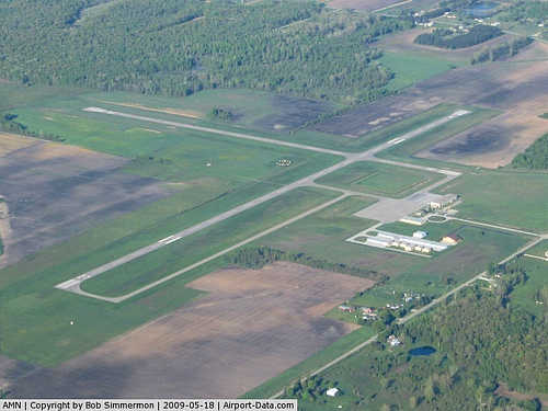 |
(Click on the photo to enlarge) |
|
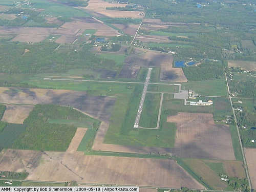 |
(Click on the photo to enlarge) |
|
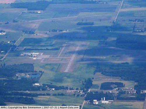 |
(Click on the photo to enlarge) |
Location & QuickFacts
| FAA Information Effective: | 2008-09-25 |
| Airport Identifier: | AMN |
| Airport Status: | Operational |
| Longitude/Latitude: | 084-41-16.6170W/43-19-19.7130N
-84.687949/43.322142 (Estimated) |
| Elevation: | 754 ft / 229.82 m (Surveyed) |
| Land: | 631 acres |
| From nearest city: | 3 nautical miles SW of Alma, MI |
| Location: | Gratiot County, MI |
| Magnetic Variation: | 05W (1990) |
Owner & Manager
| Ownership: | Publicly owned |
| Owner: | City Of Alma-co. Of Gratiot |
| Address: | 525 E Superior P.o. Box 278
Alma, MI 48801 |
| Phone number: | 989-463-5430 |
| Manager: | Douglas L. Brush |
| Address: | 3999 W. Seaman Rd.
Alma, MI 48801 |
| Phone number: | 989-463-5430 |
Airport Operations and Facilities
| Airport Use: | Open to public |
| Wind indicator: | Yes |
| Segmented Circle: | Yes |
| Control Tower: | No |
| Lighting Schedule: | DUSK-DAWN
ACTVT MIRL RYS 09/27 & 18/36; VASI RYS 09 & 27; REIL RYS 09 & 27 - CTAF. |
| Beacon Color: | Clear-Green (lighted land airport) |
| Landing fee charge: | No |
| Sectional chart: | Detroit |
| Region: | AGL - Great Lakes |
| Boundary ARTCC: | ZOB - Cleveland |
| Tie-in FSS: | LAN - Lansing |
| FSS on Airport: | No |
| FSS Toll Free: | 1-800-WX-BRIEF |
| NOTAMs Facility: | AMN (NOTAM-d service avaliable) |
| Federal Agreements: | NGY |
Airport Communications
| CTAF: | 122.800 |
| Unicom: | 122.800 |
Airport Services
| Fuel available: | 100LLA |
| Airframe Repair: | MAJOR |
| Power Plant Repair: | MAJOR |
| Bottled Oxygen: | HIGH |
| Bulk Oxygen: | NONE |
Runway Information
Runway 09/27
| Dimension: | 5000 x 75 ft / 1524.0 x 22.9 m |
| Surface: | ASPH, Good Condition |
| Weight Limit: | Single wheel: 40000 lbs.
Dual wheel: 65000 lbs. |
| Edge Lights: | Medium |
| |
Runway 09 |
Runway 27 |
| Longitude: | 084-41-45.6750W | 084-40-38.0630W |
| Latitude: | 43-19-22.8730N | 43-19-22.6550N |
| Elevation: | 749.00 ft | 752.00 ft |
| Alignment: | 90 | 127 |
| ILS Type: | SDF
| |
| Traffic Pattern: | Left | Left |
| Markings: | Non-precision instrument, Fair Condition | Non-precision instrument, Fair Condition |
| Crossing Height: | 45.00 ft | 53.00 ft |
| VASI: | 2-box on left side | 2-box on left side |
| Visual Glide Angle: | 3.00° | 3.00° |
| Runway End Identifier: | Yes | Yes |
| Obstruction: | 62 ft tree, 2308.0 ft from runway, 364 ft left of centerline, 34:1 slope to clear | 55 ft tree, 1295.0 ft from runway, 190 ft left of centerline, 20:1 slope to clear |
|
Runway 18/36
| Dimension: | 3200 x 75 ft / 975.4 x 22.9 m |
| Surface: | ASPH, Good Condition |
| Weight Limit: | Single wheel: 26000 lbs. |
| Edge Lights: | Medium |
| |
Runway 18 |
Runway 36 |
| Longitude: | 084-41-23.8280W | 084-41-24.0190W |
| Latitude: | 43-19-30.6950N | 43-18-59.1200N |
| Elevation: | 752.00 ft | 753.00 ft |
| Alignment: | 127 | 0 |
| Traffic Pattern: | Left | Left |
| Markings: | Basic, Poor Condition
RY MARKINGS BADLY FADED. | Basic, Poor Condition
RY MARKINGS BADLY FADED. |
| Obstruction: | 45 ft trees, 1100.0 ft from runway, 125 ft right of centerline, 20:1 slope to clear | 80 ft trees, 1600.0 ft from runway, 17:1 slope to clear |
|
Radio Navigation Aids
| ID |
Type |
Name |
Ch |
Freq |
Var |
Dist |
| AMN | NDB | Alma | | 329.00 | 05W | 4.3 nm |
| HYX | NDB | Browne | | 385.00 | 06W | 36.8 nm |
| GDW | NDB | Wiggins | | 209.00 | 04W | 40.0 nm |
| MOP | VOR/DME | Mount Pleasant | 043X | 110.60 | 05W | 18.2 nm |
| MBS | VOR/DME | Saginaw | 076X | 112.90 | 03W | 29.5 nm |
| HIC | VOR/DME | White Cloud | 123X | 117.60 | 01W | 47.4 nm |
| GRR | VOR/DME | Grand Rapids | 106Y | 115.95 | 04W | 47.9 nm |
| LAN | VORTAC | Lansing | 045X | 110.80 | 05W | 36.4 nm |
| FNT | VORTAC | Flint | 116X | 116.90 | 06W | 46.5 nm |
Remarks
- ANIMALS ON & INVOF ARPT.
- POWERED PARACHUTE ACTIVITY ON & INVOF ARPT.
Images and information placed above are from
http://www.airport-data.com/airport/AMN/
We thank them for the data!
| General Info
|
| Country |
United States
|
| State |
MICHIGAN
|
| FAA ID |
AMN
|
| Latitude |
43-19-19.713N
|
| Longitude |
084-41-16.617W
|
| Elevation |
754 feet
|
| Near City |
ALMA
|
We don't guarantee the information is fresh and accurate. The data may
be wrong or outdated.
For more up-to-date information please refer to other sources.
|
|


