 |
|
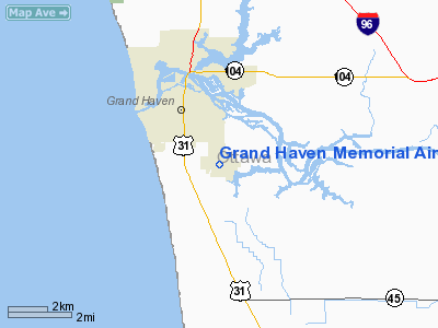
Grand Haven Memorial Airpark Airport |
| Grand Haven Memorial Airpark |
| IATA: none – ICAO: none – FAA LID: 3GM |
| Summary |
| Airport type |
Public |
| Owner |
City of Grand Haven |
| Serves |
Grand Haven, Michigan |
| Elevation AMSL |
604 ft / 184 m |
| Coordinates |
43°02′04″N 084°28′50″W / 43.03444°N 84.48056°W / 43.03444; -84.48056 |
| Runways |
| Direction |
Length |
Surface |
| ft |
m |
| 09/27 |
3750 |
1143 |
Asphalt |
| 18/36 |
2060 |
628 |
Asphalt |
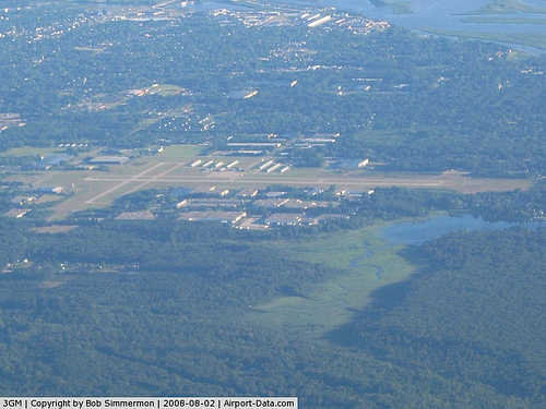
Grand Haven Memorial Airpark (FAA LID: 3GM) is a public airport owned and operated by the City of Grand Haven located 2 miles (3.2 km) southeast of Grand Haven, Michigan, United States. The airport in uncontrolled, and is used for general aviation purposes.
Additionally, radio controlled aircraft operations are permitted on the northwest side of runway 18.
On average, 48 aircraft operations occur each day, and 100% of the operations are general aviation, except for the occasional military flight. No commercial airline service is available. 42 aircraft are based on the field.
The above content comes from Wikipedia and is published under free licenses – click here to read more.
|
 |
(Click on the photo to enlarge) |
Location & QuickFacts
| FAA Information Effective: | 2008-09-25 |
| Airport Identifier: | 3GM |
| Airport Status: | Operational |
| Longitude/Latitude: | 086-11-53.4000W/43-02-02.6000N
-86.198167/43.034056 (Estimated) |
| Elevation: | 604 ft / 184.10 m (Surveyed) |
| Land: | 280 acres |
| From nearest city: | 2 nautical miles SE of Grand Haven, MI |
| Location: | Ottawa County, MI |
| Magnetic Variation: | 05W (2005) |
Owner & Manager
| Ownership: | Publicly owned |
| Owner: | City Of Grand Haven |
| Address: | 519 Washington
Grand Haven, MI 49417 |
| Phone number: | 616-842-3220 |
| Manager: | Warren Benaway |
| Address: | 16446 Comstock St
Grand Haven, MI 49417 |
| Phone number: | 616-842-4430 |
Airport Operations and Facilities
| Airport Use: | Open to public |
| Wind indicator: | Yes |
| Segmented Circle: | Yes |
| Control Tower: | No |
| Lighting Schedule: | DUSK-DAWN
ACTVT MIRL RYS 09/27 & 18/36; PAPI & REIL RYS 09 & 27 - CTAF. |
| Beacon Color: | Clear-Green (lighted land airport) |
| Landing fee charge: | No |
| Sectional chart: | Chicago |
| Region: | AGL - Great Lakes |
| Boundary ARTCC: | ZAU - Chicago |
| Tie-in FSS: | LAN - Lansing |
| FSS on Airport: | No |
| FSS Toll Free: | 1-800-WX-BRIEF |
| NOTAMs Facility: | LAN (NOTAM-d service avaliable) |
| Federal Agreements: | NGY |
Airport Communications
| CTAF: | 122.700 |
| Unicom: | 122.700 |
Airport Services
| Fuel available: | 100LLA |
| Airframe Repair: | MAJOR |
| Power Plant Repair: | MAJOR |
| Bottled Oxygen: | HIGH/LOW |
| Bulk Oxygen: | HIGH/LOW |
Runway Information
Runway 09/27
| Dimension: | 3752 x 75 ft / 1143.6 x 22.9 m |
| Surface: | ASPH, Good Condition |
| Weight Limit: | Single wheel: 8000 lbs. |
| Edge Lights: | Medium |
| |
Runway 09 |
Runway 27 |
| Longitude: | 086-12-12.0875W | 086-11-21.5691W |
| Latitude: | 43-02-02.9442N | 43-02-02.9536N |
| Elevation: | 602.00 ft | 592.00 ft |
| Alignment: | 90 | 127 |
| Traffic Pattern: | Left | Left |
| Markings: | Basic, Good Condition | Basic, Good Condition |
| Crossing Height: | 32.00 ft | 54.00 ft |
| VASI: | 2-light PAPI on left side | 2-light PAPI on left side |
| Visual Glide Angle: | 3.00° | 4.00° |
| Runway End Identifier: | Yes | Yes |
| Obstruction: | 45 ft tree, 695.0 ft from runway, 250 ft left of centerline, 11:1 slope to clear | 45 ft trees, 830.0 ft from runway, 330 ft right of centerline, 14:1 slope to clear |
|
Runway 18/36
| Dimension: | 2058 x 60 ft / 627.3 x 18.3 m |
| Surface: | ASPH, Good Condition |
| Weight Limit: | Single wheel: 8000 lbs. |
| Edge Lights: | Medium |
| |
Runway 18 |
Runway 36 |
| Longitude: | 086-12-05.2545W | 086-12-05.2779W |
| Latitude: | 43-02-12.0391N | 43-01-51.7060N |
| Elevation: | 604.00 ft | 598.00 ft |
| Alignment: | 127 | 0 |
| Traffic Pattern: | Left | Left |
| Markings: | Basic, Good Condition | Basic, Good Condition |
| Obstruction: | 16 ft road, 330.0 ft from runway, 8:1 slope to clear
RWY 18 APCH RATIO 20:1 AT THLD. | 61 ft tree, 1112.0 ft from runway, 106 ft left of centerline, 14:1 slope to clear
RWY 36 APCH RATIO 18:1 AT THLD. |
|
Radio Navigation Aids
| ID |
Type |
Name |
Ch |
Freq |
Var |
Dist |
| HLM | NDB | Holland | | 233.00 | 03W | 14.4 nm |
| GRR | VOR/DME | Grand Rapids | 106Y | 115.95 | 04W | 34.3 nm |
| PMM | VOR/DME | Pullman | 058X | 112.10 | 00E | 34.4 nm |
| HIC | VOR/DME | White Cloud | 123X | 117.60 | 01W | 38.7 nm |
| MKG | VORTAC | Muskegon | 099X | 115.20 | 01W | 10.7 nm |
Remarks
- RADIO CTL ACFT FLYING AREA NW SIDE OF RY 18.
- GCO AVBL ON FREQ 121.725 THRU MKG CD & FLT SVCS.
Images and information placed above are from
Grand Haven Memorial Airpark Airport
We thank them for the data!
| General Info
|
| Country |
United States
|
| State |
MICHIGAN
|
| FAA ID |
3GM
|
| Latitude |
43-02-02.567N
|
| Longitude |
086-11-53.385W
|
| Elevation |
604 feet
|
| Near City |
GRAND HAVEN
|
We don't guarantee the information is fresh and accurate. The data may
be wrong or outdated.
For more up-to-date information please refer to other sources.
|
|


