 |
|
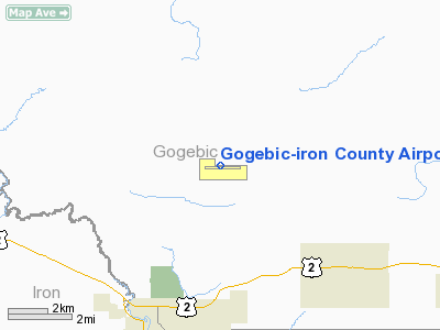
Gogebic - Iron County Airport |
| Gogebic-Iron County Airport |
| IATA: IWD – ICAO: KIWD – FAA LID: IWD |
| Summary |
| Airport type |
Public |
| Operator |
Gogebic County |
| Location |
Ironwood, Michigan |
| Elevation AMSL |
1,230 ft / 374.9 m |
| Coordinates |
46°31′39″N 90°07′53″W / 46.5275°N 90.13139°W / 46.5275; -90.13139Coordinates: 46°31′39″N 90°07′53″W / 46.5275°N 90.13139°W / 46.5275; -90.13139 |
| Runways |
| Direction |
Length |
Surface |
| ft |
m |
| 9/27 |
6,501 |
1,982 |
Asphalt |
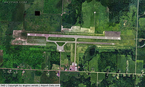
Gogebic-Iron County Airport (IATA: IWD, ICAO: KIWD, FAA LID: IWD) is a public airport located seven miles (11 km) northeast of the central business district (CBD) of Ironwood, a city in Gogebic County on the western edge of the U.S. state of Michigan. The airport covers 1,180 acres (478 ha) and has one runway. It is mostly used for general aviation. Essential Air Service provides commercial air service to MKE.
Airlines and destinations
| Airlines |
Destinations |
| Great Lakes Airlines |
Milwaukee, Rhinelander |
The above content comes from Wikipedia and is published under free licenses – click here to read more.
|
 |
(Click on the photo to enlarge) |
Location & QuickFacts
| FAA Information Effective: | 2008-09-25 |
| Airport Identifier: | IWD |
| Airport Status: | Operational |
| Longitude/Latitude: | 090-07-53.0280W/46-31-38.9090N
-90.131397/46.527475 (Estimated) |
| Elevation: | 1230 ft / 374.90 m (Surveyed) |
| Land: | 1180 acres |
| From nearest city: | 7 nautical miles NE of Ironwood, MI |
| Location: | Gogebic County, MI |
| Magnetic Variation: | 00E (1985) |
Owner & Manager
| Ownership: | Publicly owned |
| Owner: | Gogebic County |
| Address: | Gogebic Co Court House
Bessemer, MI 49911 |
| Phone number: | 906-932-3121 |
| Manager: | Duane Duray |
| Address: | E 5560 Airport Road
Ironwood, MI 49938 |
| Phone number: | 906-932-3121 |
Airport Operations and Facilities
| Airport Use: | Open to public |
| Wind indicator: | Yes |
| Segmented Circle: | Yes |
| Control Tower: | No |
| Lighting Schedule: | DUSK-DAWN
ACTVT HIRL RY 09/27; REIL RY 09 & MALSR RY 27 - CTAF. |
| Beacon Color: | Clear-Green (lighted land airport) |
| Landing fee charge: | Yes
LANDING FEES WAIVED IF FUEL PURCHASED. |
| Sectional chart: | Green Bay |
| Region: | AGL - Great Lakes |
| Boundary ARTCC: | ZMP - Minneapolis |
| Tie-in FSS: | GRB - Green Bay |
| FSS on Airport: | No |
| FSS Toll Free: | 1-800-WX-BRIEF |
| NOTAMs Facility: | IWD (NOTAM-d service avaliable) |
| Certification type/date: | II A S 05/197
ARPT CLSD TO UNSKED ACR OPNS WITH MORE THAN 30 PSGR SEATS EXCP 48 HR PPR CALL AMGR 906-932-3121. |
| Federal Agreements: | NGY |
Airport Communications
| CTAF: | 122.800 |
| Unicom: | 122.800 |
Airport Services
| Fuel available: | 100LLA |
| Bottled Oxygen: | NONE |
| Bulk Oxygen: | NONE |
Runway Information
Runway 09/27
| Dimension: | 6501 x 130 ft / 1981.5 x 39.6 m |
| Surface: | ASPH, Fair Condition |
| Surface Treatment: | Saw-cut or plastic Grooved |
| Weight Limit: | Single wheel: 85000 lbs.
Dual wheel: 150000 lbs.
Dual tandem wheel: 280000 lbs. |
| Edge Lights: | High |
| |
Runway 09 |
Runway 27 |
| Longitude: | 090-08-39.5020W | 090-07-06.5390W |
| Latitude: | 46-31-39.0410N | 46-31-38.8150N |
| Elevation: | 1223.00 ft | 1230.00 ft |
| Alignment: | 90 | 127 |
| ILS Type: | | ILS
|
| Traffic Pattern: | Left | Left |
| Markings: | Precision instrument, Good Condition | Precision instrument, Good Condition |
| Crossing Height: | 47.00 ft | 0.00 ft |
| VASI: | 4-box on left side | |
| Visual Glide Angle: | 3.00° | 0.00° |
| Approach lights: | | MALSR |
| Runway End Identifier: | Yes
OTS INDEFLY. | |
| Obstruction: | 97 ft trees, 2817.0 ft from runway, 587 ft right of centerline, 26:1 slope to clear | 104 ft trees, 4578.0 ft from runway, 480 ft left of centerline, 42:1 slope to clear |
|
Radio Navigation Aids
| ID |
Type |
Name |
Ch |
Freq |
Var |
Dist |
| MHA | NDB | Manitowish | | 364.00 | 01W | 26.4 nm |
| BDJ | NDB | Boulder Junction | | 206.00 | 02E | 30.8 nm |
| ENY | NDB | Kennedy | | 254.00 | 02E | 32.4 nm |
| PKF | NDB | Park Falls | | 371.00 | 01W | 36.6 nm |
| OGM | NDB | Ontonagon | | 375.00 | 00W | 37.1 nm |
| RXW | NDB | Watersmeet | | 407.00 | 01E | 38.2 nm |
| ARV | NDB | Arbor Vitae | | 221.00 | 01W | 39.8 nm |
| LNL | NDB | Land O Lakes | | 396.00 | 02W | 44.4 nm |
| DO | NDB | Dougy | | 236.00 | 01W | 44.9 nm |
| ASX | VOR/DME | Ashland | 039X | 110.20 | 02E | 32.5 nm |
| IWD | VORTAC | Ironwood | 025X | 108.80 | 01E | 0.4 nm |
Remarks
- VARIOUS WILDLIFE ON & INVOF ARPT.
- ARPT SIGNS ARE NORMALLY SNOW COVERED DURING WINTER MONTHS.
- BE ALERT FOR PAEW DURING SNOW REMOVAL.
- FIREFIGHTING PERSONNEL WILL BE MONITORING CTAF DURING ALL SCHEDULED ACR OPNS.
- ARPT WILL BE MONITORING CTAF DURING ALL SCHEDULED ACR OPNS TO CONVEY LATEST RY CONDS DURING WINTER WX.
Images and information placed above are from
http://www.airport-data.com/airport/IWD/
We thank them for the data!
| General Info
|
| Country |
United States
|
| State |
MICHIGAN
|
| FAA ID |
IWD
|
| Latitude |
46-31-38.909N
|
| Longitude |
090-07-53.028W
|
| Elevation |
1230 feet
|
| Near City |
IRONWOOD
|
We don't guarantee the information is fresh and accurate. The data may
be wrong or outdated.
For more up-to-date information please refer to other sources.
|
|


