 |
|
Gerald R. Ford International Airport |
Coordinates: 42°52′51″N 085°31′22″W / 42.88083°N 85.52278°W / 42.88083; -85.52278
| Gerald R. Ford International Airport |
 |
| Gerald R. Ford International Airport |
| IATA: GRR – ICAO: KGRR – FAA LID: GRR
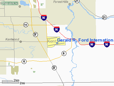
Location of the Gerald R. Ford International Airport
|
| Summary |
| Airport type |
Public |
| Owner |
Kent County Department of Aeronautics |
| Serves |
Grand Rapids, Michigan |
| Elevation AMSL |
794 ft / 242 m |
| Website |
www.GRR.org |
| Runways |
| Direction |
Length |
Surface |
| ft |
m |
| 8R/26L |
10,000 |
3,048 |
Concrete |
| 8L/26R |
5,000 |
1,524 |
Concrete |
| 17/35 |
8,501 |
2,591 |
Concrete |
| Statistics (2009) |
| Total Passengers |
1,771,465 ▼ 2% |
| Aircraft movements |
87,883 ▼ 10% |
| Sources: airport web site and FAA |
Gerald R. Ford International Airport (IATA: GRR, ICAO: KGRR, FAA LID: GRR) is a commercial airport located a few miles southeast of Grand Rapids, Michigan in Cascade Township. Originally called Kent County Airport and later renamed Kent County International Airport; in December 1999 the airport was renamed for former resident Gerald R. Ford, the 38th President of the United States. GRR is the largest regional commercial service airport serving the West Michigan region, which connects to major airports such as Detroit Metro, Chicago O'Hare, Minneapolis/ St. Paul, Memphis, Denver, and Las Vegas. It offers no direct service to international destinations other than Toronto. The airport serves as a focus city for Allegiant Air. HistoryAviation first came to Kent County on September 10, 1911, when a Wright Biplane landed at the Comstock Park State Fairgrounds. Grand Rapids' first airport broke ground in November 1919, four miles (6 km) south of downtown.
The first regularly scheduled air service in the United States was between Grand Rapids and Detroit (actually Dearborn's Ford Airport) on a Ford-Stout monoplane named Miss Grand Rapids, which commenced July 26, 1926.
In 1948, the airport was expanded across 44th Street, and for a time, movable gates were used to keep traffic off of the runway while it was in use.
In 1959, construction began on a new facility in Cascade Township, several miles east of the original location. The new airport was opened on November 23, 1963, and officially dedicated on June 6, 1964.
The first scheduled Boeing 737-200 flight was flown for United Airlines on April 28, 1968 from Chicago O'Hare to Grand Rapids. The aircraft, registration number N9022U, was named The Jet Mainliner City of Grand Rapids.
On January 27, 1977, Kent County Airport was renamed Kent County International Airport with the opening of a U.S. Customs Bureau Office in the main terminal building.
In 1997, the new 8,500-foot (2,600 m) runway 17/35 was added to allow the airport to continue operations during the $32 million reconstruction of runway 8R/26L, completed in 2001. Also, the passenger terminal's renovation project was completed in 2000, at a cost of approximately $50 million.
In 2004, the airport served more than 2 million passengers for the first time in a single year.
Facilities
Gerald R. Ford International Airport has two parallel east-west runways and one north-south runway. Along with cargo and general aviation facilities, the airport also has one passenger terminal, consisting of a two-level main terminal and two concourses, labeled A (with six gates) and B (with six gates).
The main terminal contains the ticketing lobbies, three baggage claim carousels, a gift shop, a food court, a KidsPort play room, a game room, five conference rooms, and two public business centers. Short term and long term parking are located in front of the terminal. The main terminal has 12 gates. WiFi service is available at no cost to airport patrons throughout the terminal facility.
When new baggage screening regulations were introduced by the Transportation Security Administration, the airport was one of the first in the nation to conduct trials on the new screening machines. Due to their size, there was no room to locate the machines "behind the scenes." Instead, they were placed in the middle of the lobby.
Airlines and destinations
| Airlines |
Destinations |
Concourse |
| Air Canada operated by Air Georgian |
Toronto-Pearson |
A |
| AirTran Airways |
Baltimore, Orlando, Fort Myers, Tampa |
B |
| Allegiant Air |
Fort Lauderdale, Las Vegas, Myrtle Beach, Orlando, Phoenix/Mesa, Punta Gorda [begins November 18], St. Petersburg/Clearwater |
B |
| AmericanConnection operated by Chautauqua Airlines |
Chicago-O'Hare |
B |
| American Eagle |
Chicago-O'Hare, Dallas/Fort Worth |
B |
| Continental Connection operated by CommutAir |
Cleveland |
A |
| Continental Express operated by ExpressJet Airlines |
Cleveland, Houston-Intercontinental, Newark |
A |
| Delta Air Lines |
Atlanta, Detroit, Minneapolis/St. Paul |
A |
| Delta Connection operated by Comair |
Cincinnati/Northern Kentucky |
A |
| Delta Connection operated by Compass Airlines |
Orlando [seasonal] |
A |
| Delta Connection operated by Chautauqua Airlines |
Cincinnati/Northern Kentucky, Detroit, New York-LaGuardia |
A |
| Delta Connection operated by Mesaba Airlines |
Detroit, Minneapolis/St. Paul |
A |
| Delta Connection operated by Pinnacle Airlines |
Detroit, Memphis, Minneapolis/St. Paul, Washington-Reagan |
A |
| Frontier Airlines operated by Republic Airlines |
Denver |
A |
| Frontier Airlines operated by Chautauqua Airlines |
Milwaukee |
A |
| United Airlines |
Chicago-O'Hare |
B |
| United Express operated by GoJet Airlines |
Chicago-O'Hare, Denver |
B |
| United Express operated by Mesa Airlines |
Chicago-O'Hare |
B |
| United Express operated by Shuttle America |
Chicago-O'Hare, Denver |
B |
Cargo carriers
- ABX Air
- FedEx Express (Memphis, Indianapolis)
Ground transportation
The airport is located at the intersection of 44th Street and Patterson Avenue. It is has I-96 on the east side, M-6 on the south side, M-37 on the west side, and M-11 on the north side of the airport.
Metro Cab provides taxi and luxury sedan service at the passenger terminal building curb front. Car rental agencies are available, too.
The Rapid runs the Grand Rapids Air Porter from the airport to downtown hotels from April through October., Route 17 Woodland/Airport travels between the airport and Woodland Mall seven days a week. Routes 5 (weekdays only) and 6 (7-day service) provide service to Central Station from Woodland. From Woodland, Route 44 provides weekday only service to Rivertown Crossings Mall.
Aircraft spotting
The airport has two aircraft spotter locations. There is an observation deck located on the mezzanine level of the passenger terminal building, which gives a relatively unobstructed view of the ramp area and runway 8R and 26L.
There is a viewing area, situated on Kraft Avenue north of 52nd Street. The viewing area includes picnic tables litter barrels and a portable toilet. At the viewing area, radio station 1650 AM rebroadcasts transmissions by air traffic controllers, pilots, and GFIA airfield operations staff.
The above content comes from Wikipedia and is published under free licenses – click here to read more.
|
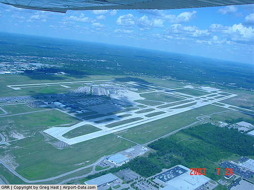 |
(Click on the photo to enlarge) |
|
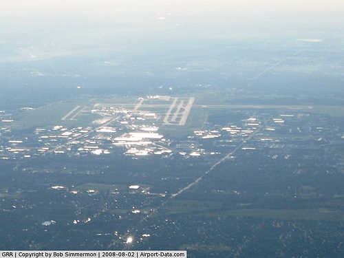 |
(Click on the photo to enlarge) |
|
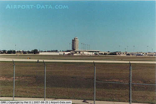 |
(Click on the photo to enlarge) |
Location & QuickFacts
| FAA Information Effective: | 2008-09-25 |
| Airport Identifier: | GRR |
| Airport Status: | Operational |
| Longitude/Latitude: | 085-31-22.1000W/42-52-51.0000N
-85.522806/42.880833 (Estimated) |
| Elevation: | 794 ft / 242.01 m (Surveyed) |
| Land: | 3127 acres |
| From nearest city: | 6 nautical miles SE of Grand Rapids, MI |
| Location: | Kent County, MI |
| Magnetic Variation: | 04W (1985) |
Owner & Manager
| Ownership: | Publicly owned |
| Owner: | Kent Co Dept Of Aeronautics |
| Address: | 5500 44th St Se
Grand Rapids, MI 49512 |
| Phone number: | 616-233-6000 |
| Manager: | James A. Koslosky |
| Address: | 5500 44th St Se
Grand Rapids, MI 49512 |
| Phone number: | 616-233-6000 |
Airport Operations and Facilities
| Airport Use: | Open to public |
| Wind indicator: | Yes |
| Segmented Circle: | No |
| Control Tower: | Yes |
| Lighting Schedule: | DUSK-DAWN
WHEN ATCT CLSD ACTVT HIRL RYS 08R/26L & 17/35; MIRL RY 08L/26R; VASI RYS 08L; 17 & 26R; PAPI RYS 26L & 35; REIL RYS 08L; 17 & 26R & MALSR RYS 08R; 26L & 35 - CTAF. |
| Beacon Color: | Clear-Green (lighted land airport) |
| Sectional chart: | Chicago |
| Region: | AGL - Great Lakes |
| Boundary ARTCC: | ZAU - Chicago |
| Tie-in FSS: | LAN - Lansing |
| FSS on Airport: | No |
| FSS Toll Free: | 1-800-WX-BRIEF |
| NOTAMs Facility: | GRR (NOTAM-d service avaliable) |
| Certification type/date: | I C S 05/1973 |
| Federal Agreements: | NGY |
Airport Communications
| CTAF: | 135.650 |
| Unicom: | 122.950 |
Airport Services
| Fuel available: | 100LLA |
| Airframe Repair: | MAJOR |
| Power Plant Repair: | MAJOR |
| Bottled Oxygen: | HIGH |
| Bulk Oxygen: | HIGH |
Runway Information
Runway 08L/26R
| Dimension: | 5000 x 100 ft / 1524.0 x 30.5 m |
| Surface: | CONC, Good Condition |
| Surface Treatment: | Saw-cut or plastic Grooved |
| Weight Limit: | Single wheel: 52000 lbs.
Dual wheel: 60000 lbs. |
| Edge Lights: | Medium |
| |
Runway 08L |
Runway 26R |
| Longitude: | 085-32-24.6880W | 085-31-18.2969W |
| Latitude: | 42-53-19.7910N | 42-53-27.2522N |
| Elevation: | 786.00 ft | 784.00 ft |
| Alignment: | 81 | 127 |
| Traffic Pattern: | Left | Left |
| Markings: | Non-precision instrument, Good Condition | Non-precision instrument, Good Condition |
| Crossing Height: | 45.00 ft | 33.00 ft |
| VASI: | 4-box on left side | 4-box on left side |
| Visual Glide Angle: | 3.00° | 3.00° |
| Runway End Identifier: | Yes | Yes |
| Centerline Lights: | No | No |
| Touchdown Lights: | No | No |
|
Runway 08R/26L
| Dimension: | 10000 x 150 ft / 3048.0 x 45.7 m |
| Surface: | CONC, Good Condition |
| Surface Treatment: | Saw-cut or plastic Grooved |
| Weight Limit: | Dual wheel: 190000 lbs.
Dual tandem wheel: 350000 lbs. |
| Edge Lights: | High |
| |
Runway 08R |
Runway 26L |
| Longitude: | 085-32-31.8623W | 085-30-19.1060W |
| Latitude: | 42-52-35.8815N | 42-52-50.8126N |
| Elevation: | 792.00 ft | 790.00 ft |
| Alignment: | 81 | 127 |
| ILS Type: | ILS
| ILS
|
| Traffic Pattern: | Left | Left |
| Markings: | Precision instrument, Good Condition | Precision instrument, Good Condition |
| Crossing Height: | 0.00 ft | 74.00 ft |
| VASI: | | 4-light PAPI on left side |
| Visual Glide Angle: | 0.00° | 3.00° |
| RVR Equipment: | touchdown, rollout | touchdown, rollout |
| Approach lights: | MALSR | MALSR |
| Runway End Identifier: | | No |
| Centerline Lights: | No | No |
| Touchdown Lights: | No | No |
|
Runway 17/35
| Dimension: | 8501 x 150 ft / 2591.1 x 45.7 m |
| Surface: | CONC, Good Condition |
| Surface Treatment: | Saw-cut or plastic Grooved |
| Weight Limit: | Dual wheel: 190000 lbs.
Dual tandem wheel: 350000 lbs. |
| Edge Lights: | High |
| |
Runway 17 |
Runway 35 |
| Longitude: | 085-31-09.3229W | 085-30-52.0722W |
| Latitude: | 42-53-22.3097N | 42-51-59.3088N |
| Elevation: | 782.00 ft | 789.00 ft |
| Alignment: | 127 | 127 |
| ILS Type: | | ILS
|
| Traffic Pattern: | Left | Left |
| Markings: | Precision instrument, Good Condition | Precision instrument, Good Condition |
| Crossing Height: | 38.00 ft | 73.00 ft |
| VASI: | 4-box on left side | 4-light PAPI on right side |
| Visual Glide Angle: | 3.00° | 3.00° |
| RVR Equipment: | | touchdown |
| Approach lights: | | MALSR |
| Runway End Identifier: | Yes | |
| Touchdown Lights: | No | |
|
Radio Navigation Aids
| ID |
Type |
Name |
Ch |
Freq |
Var |
Dist |
| HLM | NDB | Holland | | 233.00 | 03W | 28.4 nm |
| BT | NDB | Batol | | 272.00 | 04W | 34.6 nm |
| AMN | NDB | Alma | | 329.00 | 05W | 41.9 nm |
| GRR | VOR/DME | Grand Rapids | 106Y | 115.95 | 04W | 5.8 nm |
| PMM | VOR/DME | Pullman | 058X | 112.10 | 00E | 35.8 nm |
| AZO | VOR/DME | Kalamazoo | 027X | 109.00 | 01W | 38.7 nm |
| HIC | VOR/DME | White Cloud | 123X | 117.60 | 01W | 42.6 nm |
| MKG | VORTAC | Muskegon | 099X | 115.20 | 01W | 28.6 nm |
| BTL | VORTAC | Battle Creek | 031X | 109.40 | 02W | 36.3 nm |
| LAN | VORTAC | Lansing | 045X | 110.80 | 05W | 37.7 nm |
Remarks
- TWY F N OF TWY V; G & J BETWEEN F & J3 CLSD TO ACFT OVER 100,000 LBS; TWY F S OF TWY V & REMAINING SECTIONS OF TWY J CLSD TO ACFT OVER 47,OOO LBS; TWY Y 400 FT N OF TWY D CLSD TO ACFT OVER 40000 LBS; TWY R N OF TWY D CLSD TO ACFT OVR 175000 LBS.
- TWY N, NORTH OF TWY D AND TWY Z NORTH OF TWY D ARE NON-MOVEMENT AREAS.
- PUSHBACK ADVISORIES ON THE TERMINAL RAMP ARE NOTPRVDD BY ATC.
- MULTIPLE CRANES UP TO 953 FT AMSL (155 FT AGL) NW & INVOF TERMINAL BLDG.
- THE FOLLOWING AREAS ARE NOT VSB FR GRR ATCT; FM I/2 MILE WEST OF THE AER 08R CLOCKWISE TO 1/2 MILE NORTH AER 17, PORTIONS OF RY 8L & TWY J.
- BIRDS ON & INVOF ARPT.
- NOISE ABATEMENT PROCEDURES: RY 08R DEP ON RY HEADING UNTIL REACHING THE HWY EAST OF ARPT; RY 26L ON APCH TO ARPT TURN FINAL AT HWY EAST OF ARPT.
- PPR FOR ACFT WITH 171 FT WINGSPAN OR LARGER.
Images and information placed above are from
http://www.airport-data.com/airport/GRR/
We thank them for the data!
| General Info
|
| Country |
United States
|
| State |
MICHIGAN
|
| FAA ID |
GRR
|
| Latitude |
42-52-51.000N
|
| Longitude |
085-31-22.100W
|
| Elevation |
793 feet
|
| Near City |
GRAND RAPIDS
|
We don't guarantee the information is fresh and accurate. The data may
be wrong or outdated.
For more up-to-date information please refer to other sources.
|
|


