 |
|
|
 |
(Click on the photo to enlarge) |
Location & QuickFacts
| FAA Information Effective: | 2008-09-25 |
| Airport Identifier: | 48G |
| Airport Status: | Operational |
| Longitude/Latitude: | 082-53-24.8000W/43-06-12.4000N
-82.890222/43.103444 (Estimated) |
| Elevation: | 800 ft / 243.84 m (Estimated) |
| Land: | 55 acres |
| From nearest city: | 4 nautical miles SW of Yale, MI |
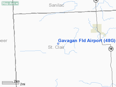
| Location: | St Clair County, MI |
| Magnetic Variation: | 06W (1985) |
Owner & Manager
| Ownership: | Privately owned |
| Owner: | Robert J. Gavagan |
| Address: | 13989 Fulton Road
Lynn, MI 48097 |
| Phone number: | 586-825-4508 |
| Manager: | Robert J. Gavagan |
| Address: | 13989 Fulton Rd
Lynn, MI 48097 |
| Phone number: | 586-825-4508 |
Airport Operations and Facilities
| Airport Use: | Open to public |
| Wind indicator: | Yes |
| Segmented Circle: | No |
| Control Tower: | No |
| Landing fee charge: | No |
| Sectional chart: | Detroit |
| Region: | AGL - Great Lakes |
| Boundary ARTCC: | ZOB - Cleveland |
| Tie-in FSS: | LAN - Lansing |
| FSS on Airport: | No |
| FSS Toll Free: | 1-800-WX-BRIEF |
| NOTAMs Facility: | LAN (NOTAM-d service avaliable) |
Airport Communications
Airport Services
| Power Plant Repair: | NONE |
| Bottled Oxygen: | NONE |
| Bulk Oxygen: | NONE |
Runway Information
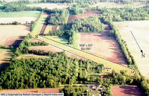
Runway 14/32
| Dimension: | 1986 x 95 ft / 605.3 x 29.0 m |
| Surface: | TURF, Fair Condition
RWY 14/32 SOFT WHEN WET. |
| |
Runway 14 |
Runway 32 |
| Longitude: | 083-53-33.1000W | 083-53-16.5000W |
| Latitude: | 43-06-20.1000N | 43-06-04.7000N |
| Traffic Pattern: | Left | Left |
| Displaced threshold: | 690.00 ft | 0.00 ft |
| Runway End Identifier: | No | No |
| Centerline Lights: | No | No |
| Touchdown Lights: | No | No |
| Obstruction: | 46 ft tree, 186.0 ft from runway, 60 ft left of centerline, 4:1 slope to clear
APCH RATIO AT DSPLCD THLD 8:1; +70 FT TREE 110 FT L; 562 FT DSTC. | 36 ft trees, 360.0 ft from runway, 65 ft left of centerline, 10:1 slope to clear |
|
Radio Navigation Aids
| ID |
Type |
Name |
Ch |
Freq |
Var |
Dist |
| ZR | NDB | Sarnia | | 404.00 | 06W | 30.5 nm |
| VQ | NDB | Cargl | | 230.00 | 05W | 45.0 nm |
| HYX | NDB | Browne | | 385.00 | 06W | 46.7 nm |
| QG | NDB | Windsor | | 353.00 | 06W | 47.5 nm |
| MTC | TACAN | Selfridge | 064X | | 06W | 29.6 nm |
| BAX | VOR/DME | Bad Axe | 019X | 108.20 | 05W | 41.1 nm |
| ECK | VORTAC | Peck | 087X | 114.00 | 07W | 11.9 nm |
| PSI | VORTAC | Pontiac | 047X | 111.00 | 03W | 37.2 nm |
| FNT | VORTAC | Flint | 116X | 116.90 | 06W | 38.5 nm |
| DET | VOT | Detroit City | | 111.60 | | 42.3 nm |
Remarks
- NO SNOW REMOVAL.
- RY 14/32 HAS 2 FT DITCH ADJ TO RY BOTH SIDES.
Images and information placed above are from
http://www.airport-data.com/airport/48G/
We thank them for the data!
| General Info
|
| Country |
United States
|
| State |
MICHIGAN
|
| FAA ID |
48G
|
| Latitude |
43-06-15.095N
|
| Longitude |
082-53-24.758W
|
| Elevation |
800 feet
|
| Near City |
YALE
|
We don't guarantee the information is fresh and accurate. The data may
be wrong or outdated.
For more up-to-date information please refer to other sources.
|
|


