 |
|
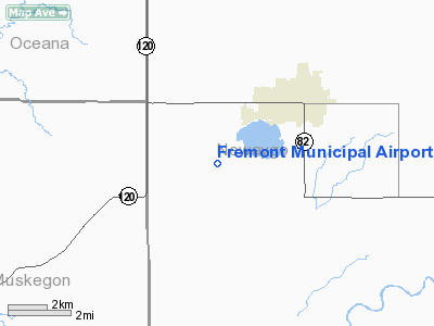
Fremont Municipal Airport |
| Fremont Municipal Airport |
| IATA: none – ICAO: KFFX – FAA LID: FFX |
| Summary |
| Airport type |
Public |
| Owner |
City of Fremont |
| Serves |
Fremont, Michigan |
| Elevation AMSL |
772 ft / 235 m |
| Coordinates |
43°26′22″N 085°59′42″W / 43.43944°N 85.995°W / 43.43944; -85.995 |
| Website |
CityOfFremont.net/... |
| Runways |
| Direction |
Length |
Surface |
| ft |
m |
| 18/36 |
6,498 |
1,981 |
Asphalt |
| 9/27 |
3,502 |
1,067 |
Asphalt |
| Statistics (2006) |
| Aircraft operations |
10,020 |
| Based aircraft |
36 |
| Source: Federal Aviation Administration |
Fremont Municipal Airport (ICAO: KFFX, FAA LID: FFX, formerly 3FM) is a city-owned public-use airport located three nautical miles (6 km) southwest of the central business district of Fremont, a city in Newaygo County, Michigan, United States. The airport in uncontrolled, and is used for general aviation purposes. Additionally, skydiving and ultralight activity is conducted at the field. No commercial airline service is available.
Although most U.S. airports use the same three-letter location identifier for the FAA and IATA, this airport is assigned FFX by the FAA but has no designation from the IATA.
Facilities and aircraft
Fremont Municipal Airport covers an area of 105 acres (42 ha) at an elevation of 772 feet (235 m) above mean sea level. It has two asphalt paved runways: 18/36 is 6,498 by 100 feet (1,981 x 30 m) and 9/27 is 3,502 by 75 feet (1,067 x 23 m).
For the 12-month period ending December 31, 2006, the airport had 10,020 aircraft operations, an average of 27 per day: 99.8% general aviation and 0.2% military. At that time there were 36 aircraft based at this airport: 86% single-engine, 8% multi-engine and 6% glider.
The above content comes from Wikipedia and is published under free licenses – click here to read more.
Location & QuickFacts
| FAA Information Effective: | 2008-09-25 |
| Airport Identifier: | FFX |
| Airport Status: | Operational |
| Longitude/Latitude: | 085-59-41.6000W/43-26-21.5000N
-85.994889/43.439306 (Estimated) |
| Elevation: | 772 ft / 235.31 m (Surveyed) |
| Land: | 105 acres |
| From nearest city: | 3 nautical miles SW of Fremont, MI |
| Location: | Newaygo County, MI |
| Magnetic Variation: | 04W (1995) |
Owner & Manager
| Ownership: | Publicly owned |
| Owner: | City Of Fremont |
| Address: | 101 E Main St
Fremont, MI 49412 |
| Phone number: | 231-924-2101 |
| Manager: | John Grasley |
| Address: | 7756 W. 60th St
Fremont, MI 49412 |
| Phone number: | 231-924-7080 |
Airport Operations and Facilities
| Airport Use: | Open to public |
| Wind indicator: | Yes |
| Segmented Circle: | Yes |
| Control Tower: | No |
| Lighting Schedule: | DUSK-DAWN
ACTVT MIRL RYS 09/27 & 18/36, REIL RYS 18 & 36, VASI RY 36 & PAPI RY 18 & 27 - CTAF. |
| Beacon Color: | Clear-Green (lighted land airport) |
| Landing fee charge: | No |
| Sectional chart: | Chicago |
| Region: | AGL - Great Lakes |
| Boundary ARTCC: | ZAU - Chicago |
| Tie-in FSS: | LAN - Lansing |
| FSS on Airport: | No |
| FSS Toll Free: | 1-800-WX-BRIEF |
| NOTAMs Facility: | LAN (NOTAM-d service avaliable) |
| Federal Agreements: | NGY |
Airport Communications
| CTAF: | 123.000 |
| Unicom: | 123.000 |
Airport Services
| Fuel available: | 100LLA |
| Airframe Repair: | MAJOR |
| Power Plant Repair: | MAJOR |
| Bottled Oxygen: | NONE |
| Bulk Oxygen: | NONE |
Runway Information
Runway 09/27
| Dimension: | 3502 x 75 ft / 1067.4 x 22.9 m |
| Surface: | ASPH, Good Condition |
| Weight Limit: | Single wheel: 16000 lbs. |
| Edge Lights: | Medium |
| |
Runway 09 |
Runway 27 |
| Longitude: | 085-59-54.2470W | 085-59-06.7863W |
| Latitude: | 43-26-37.9070N | 43-26-37.4231N |
| Elevation: | 767.00 ft | 770.00 ft |
| Alignment: | 91 | 127 |
| Traffic Pattern: | Left | Left |
| Markings: | Non-precision instrument, Good Condition | Non-precision instrument, Good Condition |
| Crossing Height: | 0.00 ft | 25.00 ft |
| VASI: | | 4-light PAPI on left side |
| Visual Glide Angle: | 0.00° | 3.50° |
| Runway End Identifier: | No | No |
| Centerline Lights: | No | No |
| Touchdown Lights: | No | No |
| Obstruction: | , 50:1 slope to clear | 66 ft trees, 1557.0 ft from runway, 106 ft right of centerline, 20:1 slope to clear
8 FT POLE (WINDSOCK) 112 FT L 0 FT FM RY END. |
|
Runway 18/36
| Dimension: | 6498 x 100 ft / 1980.6 x 30.5 m |
| Surface: | ASPH, Good Condition |
| Weight Limit: | Single wheel: 30000 lbs. |
| Edge Lights: | Medium |
| |
Runway 18 |
Runway 36 |
| Longitude: | 085-59-47.8912W | 085-59-47.3449W |
| Latitude: | 43-26-44.8542N | 43-25-40.6791N |
| Elevation: | 770.00 ft | 754.00 ft |
| Alignment: | 127 | 127 |
| Traffic Pattern: | Left | Left |
| Markings: | Non-precision instrument, Fair Condition | Non-precision instrument, Fair Condition |
| Crossing Height: | 25.00 ft | 45.00 ft |
| VASI: | 4-light PAPI on left side
PAPI RY 18 OTS INDEFLY. | 2-box on left side |
| Visual Glide Angle: | 3.00° | 3.00° |
| Runway End Identifier: | Yes | Yes |
| Centerline Lights: | No | No |
| Touchdown Lights: | No | No |
| Obstruction: | 39 ft pline, 1526.0 ft from runway, 34:1 slope to clear | 56 ft tree, 2104.0 ft from runway, 125 ft left of centerline, 34:1 slope to clear |
|
Radio Navigation Aids
| ID |
Type |
Name |
Ch |
Freq |
Var |
Dist |
| LDM | NDB | Ludington | | 341.00 | 03W | 36.3 nm |
| HLM | NDB | Holland | | 233.00 | 03W | 39.3 nm |
| HIC | VOR/DME | White Cloud | 123X | 117.60 | 01W | 14.6 nm |
| GRR | VOR/DME | Grand Rapids | 106Y | 115.95 | 04W | 44.9 nm |
| MKG | VORTAC | Muskegon | 099X | 115.20 | 01W | 16.3 nm |
Remarks
- GLIDER & ULTRALIGHT ACTVTY ON & INVOF ARPT.
- SEAPLANE ACTVTY ON ADJACENT LAKE .5 MI NE OF ARPT.
- SKYDIVING ACTVY SUMMER MONTHS, WEEKENDS SR-SS, OCNL WEEKDAYS NOON-SS.
Images and information placed above are from
http://www.airport-data.com/airport/FFX/
We thank them for the data!
We don't guarantee the information is fresh and accurate. The data may
be wrong or outdated.
For more up-to-date information please refer to other sources.
|
|


