 |
|
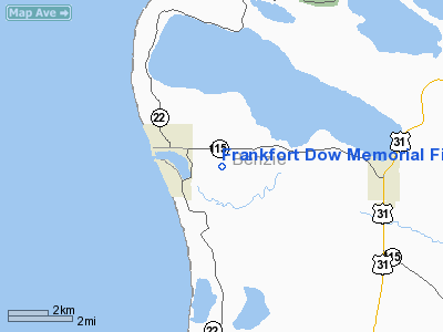
Frankfort Dow Memorial Field Airport |
| Frankfort Dow Memorial Field |
| IATA: none – ICAO: KFKS – FAA LID: FKS |
| Summary |
| Airport type |
Public |
| Owner |
Frankfort City-County Airport Authority |
| Serves |
Frankfort, Michigan |
| Elevation AMSL |
633 ft / 193 m |
| Coordinates |
44°37′31″N 086°12′03″W / 44.62528°N 86.20083°W / 44.62528; -86.20083 |
| Website |
FrankfortDowField.com |
| Runways |
| Direction |
Length |
Surface |
| ft |
m |
| 15/33 |
4,050 |
1,234 |
Asphalt |
| Statistics (2007) |
| Aircraft operations |
4,000 |
| Based aircraft |
23 |
| Source: Federal Aviation Administration |
Frankfort Dow Memorial Field (ICAO: KFKS, FAA LID: FKS, formerly 3D4) is a public use airport located two nautical miles (3.7 km) southeast of the central business district of Frankfort, a city in Benzie County, Michigan, United States. It is owned by the Frankfort City-County Airport Authority. According to the FAA's National Plan of Integrated Airport Systems for 2009–2013, it is categorized as a general aviation airport.
Although many U.S. airports use the same three-letter location identifier for the FAA and IATA, this airport is assigned FKS by the FAA and no designation from the IATA (which assigned FKS to Fukushima Airport in Fukushima Prefecture, Japan). Facilities and aircraft
Frankfort Dow Memorial Field covers an area of 168 acres (68 ha) at an elevation of 633 feet (193 m) above mean sea level. It has one runway designated 15/33 with an asphalt surface measuring 4,050 by 75 feet (1,234 x 23 m). The airport is staffed from 8AM until 5PM.
For the 12-month period ending December 31, 2007, the airport had 4,000 general aviation aircraft operations, an average of 10 per day. At that time there were 23 aircraft based at this airport: 65.2% single-engine, 4.3% multi-engine, 26.1% glider and 4.3% ultralight.
Transit
The airport is accessible by road from Airport Rd, and is close to M-22 and M-115.
The above content comes from Wikipedia and is published under free licenses – click here to read more.
Location & QuickFacts
| FAA Information Effective: | 2008-09-25 |
| Airport Identifier: | FKS |
| Airport Status: | Operational |
| Longitude/Latitude: | 086-12-02.9100W/44-37-30.7900N
-86.200808/44.625219 (Estimated) |
| Elevation: | 633 ft / 192.94 m (Surveyed) |
| Land: | 168 acres |
| From nearest city: | 2 nautical miles SE of Frankfort, MI |
| Location: | Benzie County, MI |
| Magnetic Variation: | 04W (1985) |
Owner & Manager
| Ownership: | Publicly owned |
| Owner: | Frankfort City-co Arpt Auth |
| Address: | 412 Main St, P O Box 351
Frankfort, MI 49635 |
| Phone number: | 231-352-9118 |
| Manager: | Jay T. Darling |
| Address: | 412 Main Street, P.o. Box 351
Frankfort, MI 49635 |
| Phone number: | 231-352-9118 |
Airport Operations and Facilities
| Airport Use: | Open to public |
| Wind indicator: | Yes |
| Segmented Circle: | Yes |
| Control Tower: | No |
| Lighting Schedule: | DUSK-DAWN
ACTVT MIRL RY 15/33; REIL RY 33; PAPI RY 33 - CTAF. |
| Beacon Color: | Clear-Green (lighted land airport)
ARPT BCN LOCATED ON HILL 1.25 MILES NW OF ARPT. |
| Landing fee charge: | No |
| Sectional chart: | Green Bay |
| Region: | AGL - Great Lakes |
| Boundary ARTCC: | ZMP - Minneapolis |
| Tie-in FSS: | LAN - Lansing |
| FSS on Airport: | No |
| FSS Toll Free: | 1-800-WX-BRIEF |
| NOTAMs Facility: | LAN (NOTAM-d service avaliable) |
| Federal Agreements: | N1 |
Airport Communications
| CTAF: | 123.050 |
| Unicom: | 123.050 |
Airport Services
| Fuel available: | 100LL
SELF-SERVE W/ MAJOR CREDIT CARD |
| Bottled Oxygen: | NONE |
| Bulk Oxygen: | NONE |
Runway Information
Runway 15/33
| Dimension: | 4050 x 75 ft / 1234.4 x 22.9 m |
| Surface: | ASPH, Good Condition |
| Weight Limit: | Single wheel: 25000 lbs. |
| Edge Lights: | Medium |
| |
Runway 15 |
Runway 33 |
| Longitude: | 086-12-21.3220W | 086-11-44.8380W |
| Latitude: | 44-37-45.8960N | 44-37-15.5560N |
| Elevation: | 633.00 ft | 606.00 ft |
| Alignment: | 127 | 127 |
| Traffic Pattern: | Left | Left |
| Markings: | Basic, Good Condition | Basic, Good Condition |
| Crossing Height: | 0.00 ft | 25.00 ft |
| Displaced threshold: | 1094.00 ft | 111.00 ft |
| VASI: | | 2-light PAPI on right side |
| Visual Glide Angle: | 0.00° | 3.00° |
| Runway End Identifier: | No | Yes |
| Centerline Lights: | No | No |
| Touchdown Lights: | No | No |
| Obstruction: | 20 ft road, 201.0 ft from runway, 230 ft left of centerline
RY 15 APCH RATIO 16:1 TO DSPLCD THLD OVR 151 FT TREES 2492 FT DSTC 350 FT L.
+20 FT RD. | 54 ft trees, 842.0 ft from runway, 275L/ ft right of centerline, 12:1 slope to clear
APCH RATIO 20:1 TO DSPLD THLD OVER +49 FT TREES, 980 FT DSTC, 380 FT L. |
|
Radio Navigation Aids
| ID |
Type |
Name |
Ch |
Freq |
Var |
Dist |
| TV | NDB | Gwenn | | 365.00 | 05W | 33.6 nm |
| CAD | NDB | Cadillac | | 269.00 | 04W | 39.8 nm |
| LDM | NDB | Ludington | | 341.00 | 03W | 40.8 nm |
| CXK | NDB | Clam Lake | | 251.00 | 05W | 44.2 nm |
| MBL | VOR/DME | Manistee | 051X | 111.40 | 05W | 21.4 nm |
| TVC | VORTAC | Traverse City | 093X | 114.60 | 02W | 28.0 nm |
Remarks
- RC MODEL ACFT OPER W OF RY.
- EXTSV SOARING ACTIVITY & GLIDER TOWING OPNS WEST OF RY.
- GCO AVBL ON FREQ 121.725 THRU MINNEAPOLIS ARTCC & FLT SVCS.
- DEER & BIRDS ON & INVOF ARPT.
Images and information placed above are from
http://www.airport-data.com/airport/FKS/
We thank them for the data!
| General Info
|
| Country |
United States
|
| State |
MICHIGAN
|
| FAA ID |
FKS
|
| Latitude |
44-37-30.790N
|
| Longitude |
086-12-02.910W
|
| Elevation |
632 feet
|
| Near City |
FRANKFORT
|
We don't guarantee the information is fresh and accurate. The data may
be wrong or outdated.
For more up-to-date information please refer to other sources.
|
|


