 |
|
Coordinates: 45°49′06″N 088°06′52″W / 45.81833°N 88.11444°W / 45.81833; -88.11444
| Ford Airport |
| IATA: IMT – ICAO: KIMT – FAA LID: IMT |
| Summary |
| Airport type |
Public |
| Owner |
Dickinson County |
| Serves |
Iron Mountain, Michigan |
| Elevation AMSL |
1,182 ft / 360 m |
| Runways |
| Direction |
Length |
Surface |
| ft |
m |
| 1/19 |
6,500 |
1,981 |
Asphalt |
| 13/31 |
3,812 |
1,162 |
Asphalt |
| Statistics (2007) |
| Aircraft operations |
7,606 |
| Sources: airport web site and FAA |
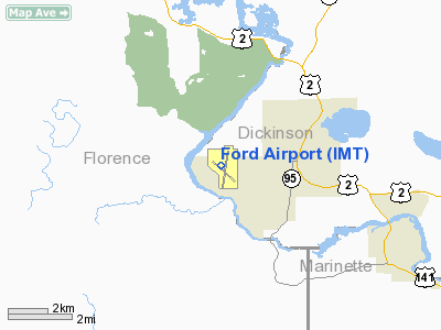
Ford Airport (IATA: IMT, ICAO: KIMT, FAA LID: IMT) is located in the central Upper Peninsula of Michigan, three miles (5 km) west of the central business district of Iron Mountain, a city in Dickinson County, Michigan, United States. The airport offers scheduled service from one commercial airline which is subsidized by the Essential Air Service program.
Ford Airport serves the greater Dickinson County area which includes the cities of Iron Mountain, Kingsford and Norway in Michigan and the bordering Wisconsin communities of Aurora, Florence and Niagara. Its service area also includes portions of Iron and Menominee counties in Michigan and Florence and Marinette counties in Wisconsin. Facilities and aircraft
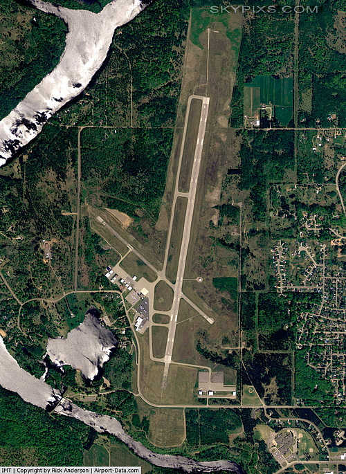
Ford Airport covers an area of 720 acres (291 ha) which contains two asphalt paved runways: 1/19 measuring 6,500 x 150 ft. (1,981 x 46 m) and 13/31 measuring 3,812 x 75 ft. (1,162 x 23 m). For the 12-month period ending April 18, 2007, the airport had 7,606 aircraft operations, an average of 20 per day: 57% air taxi, 27% scheduled commercial, 16% general aviation and <1% military.
Airlines and destinations
| Airlines |
Destinations |
| Delta Connection operated by Mesaba Airlines |
Detroit, Escanaba, Minneapolis/St. Paul |
Charter
| Airlines |
Destinations |
| Superior Aviation |
Lansing |
The above content comes from Wikipedia and is published under free licenses – click here to read more.
|
 |
(Click on the photo to enlarge) |
Location & QuickFacts
| FAA Information Effective: | 2008-09-25 |
| Airport Identifier: | IMT |
| Airport Status: | Operational |
| Longitude/Latitude: | 088-06-52.3530W/45-49-06.0750N
-88.114542/45.818354 (Estimated) |
| Elevation: | 1182 ft / 360.27 m (Surveyed) |
| Land: | 720 acres |
| From nearest city: | 3 nautical miles W of Iron Mountain Kingsford, MI |
| Location: | Dickinson County, MI |
| Magnetic Variation: | 02W (1985) |
Owner & Manager
| Ownership: | Publicly owned |
| Owner: | Dickinson County |
| Address: | County Court House
Iron Mountain, MI 49802 |
| Phone number: | 906-774-2573 |
| Manager: | William H. Marchetti |
| Address: | Ford Arpt
Kingsford, MI 49801 |
| Phone number: | 906-774-4870 |
Airport Operations and Facilities
| Airport Use: | Open to public |
| Wind indicator: | Yes |
| Segmented Circle: | Yes |
| Control Tower: | No |
| Lighting Schedule: | RDO-CTL
ACTVT HIRL RY 01/19; MIRL RY 13/31; VASI RYS 19 & 31; REIL RYS 19 & 31; MALSR RY 01 - CTAF. |
| Beacon Color: | Clear-Green (lighted land airport) |
| Landing fee charge: | Yes |
| Sectional chart: | Green Bay |
| Region: | AGL - Great Lakes |
| Traffic Pattern Alt: | 800 ft |
| Boundary ARTCC: | ZMP - Minneapolis |
| Tie-in FSS: | GRB - Green Bay |
| FSS on Airport: | No |
| FSS Toll Free: | 1-800-WX-BRIEF |
| NOTAMs Facility: | IMT (NOTAM-d service avaliable) |
| Certification type/date: | II A S 05/197
ACR OPS INVOLVING ACFT WITH MORE THAN 9 PSGR SEATS ARE NOT AUZD IN EXCESS OF 15 MINUTES BEFORE OR AFTER SCHEDULED ARR/DEP TIMES WO PRIOR COORDINATION WITH ARPT MGR AND CONFIRMATION THAT ARFF IS AVBL PRIOR TO TKF OR LDG. |
| Federal Agreements: | NGY |
Airport Communications
| CTAF: | 122.800 |
| Unicom: | 122.800
UNICOM MONITORED PART TIME. |
Airport Services
| Fuel available: | 100LLA |
| Airframe Repair: | MAJOR |
| Power Plant Repair: | MAJOR |
| Bottled Oxygen: | LOW |
| Bulk Oxygen: | NONE |
Runway Information
Runway 01/19
| Dimension: | 6500 x 150 ft / 1981.2 x 45.7 m |
| Surface: | ASPH, Good Condition |
| Surface Treatment: | Porous Friction Course |
| Weight Limit: | Single wheel: 100000 lbs.
Dual wheel: 100000 lbs.
Dual tandem wheel: 190000 lbs. |
| Edge Lights: | High |
| |
Runway 01 |
Runway 19 |
| Longitude: | 088-06-54.4980W | 088-06-42.2460W |
| Latitude: | 45-48-37.8600N | 45-49-41.4500N |
| Elevation: | 1132.00 ft | 1182.00 ft |
| Alignment: | 8 | 127 |
| ILS Type: | ILS
| |
| Traffic Pattern: | Left | Left |
| Markings: | Precision instrument, Fair Condition | Precision instrument, Fair Condition |
| Crossing Height: | 0.00 ft | 42.00 ft |
| VASI: | | 4-box on left side |
| Visual Glide Angle: | 0.00° | 3.00° |
| Approach lights: | MALSR | |
| Runway End Identifier: | No | Yes |
| Centerline Lights: | No | No |
| Touchdown Lights: | No | No |
| Obstruction: | 70 ft trees, 2900.0 ft from runway, 50 ft right of centerline, 38:1 slope to clear | , 50:1 slope to clear |
|
Runway 13/31
| Dimension: | 3812 x 75 ft / 1161.9 x 22.9 m |
| Surface: | ASPH, Good Condition |
| Weight Limit: | Single wheel: 30000 lbs.
Dual wheel: 50000 lbs.
Dual tandem wheel: 80000 lbs. |
| Edge Lights: | Medium |
| |
Runway 13 |
Runway 31 |
| Longitude: | 088-07-19.1510W | 088-06-39.1380W |
| Latitude: | 45-49-12.5500N | 45-48-47.3880N |
| Elevation: | 1129.00 ft | 1124.00 ft |
| Alignment: | 127 | 127 |
| Traffic Pattern: | Left | Left |
| Markings: | Non-precision instrument, Fair Condition | Non-precision instrument, Fair Condition |
| Crossing Height: | 0.00 ft | 40.00 ft |
| VASI: | | 4-box on left side |
| Visual Glide Angle: | 0.00° | 4.00° |
| Runway End Identifier: | No | Yes |
| Centerline Lights: | No | No |
| Touchdown Lights: | No | No |
| Obstruction: | 24 ft trees, 500.0 ft from runway, 12:1 slope to clear | 63 ft trees, 1277.0 ft from runway, 312 ft left of centerline, 17:1 slope to clear |
|
Radio Navigation Aids
| ID |
Type |
Name |
Ch |
Freq |
Var |
Dist |
| EGV | NDB | Eagle River | | 341.00 | 02W | 48.6 nm |
| LNL | NDB | Land O Lakes | | 396.00 | 02W | 49.9 nm |
| IMT | VOR/DME | Iron Mountain | 049X | 111.20 | 02W | 0.2 nm |
| MNM | VOR/DME | Menominee | 033X | 109.60 | 00E | 43.1 nm |
| ESC | VOR/DME | Escanaba | 045X | 110.80 | 00E | 43.4 nm |
| SAW | VOR/DME | Sawyer | 118X | 117.10 | 04W | 44.2 nm |
| MQT | VOR/DME | Marquette/dcmsnd | 114X | 116.70 | 02W | 48.1 nm |
Remarks
- DEER; COYOTES & BIRDS ON & INVOF ARPT.
- 48 HRS PPR FOR UNSKED ACR OPNS WITH MORE THAN 30 PSGR SEATS CALL 906-774-4830.
- ARFF CREWS WILL BE MONITORING UNICOM / CTAF DURING ALL AIR CARRIER OPS.
- SNOW REMOVAL CREW WILL BE MONITORING CTAF/UNICOM DURING ALL AIR CARRIER OPS TO PASS ALONG UPDATED SURFACE CONDITION REPORTS.
Images and information placed above are from
http://www.airport-data.com/airport/IMT/
We thank them for the data!
| General Info
|
| Country |
United States
|
| State |
MICHIGAN
|
| FAA ID |
IMT
|
| Latitude |
45-49-06.075N
|
| Longitude |
088-06-52.353W
|
| Elevation |
1182 feet
|
| Near City |
IRON MOUNTAIN KINGSFORD
|
We don't guarantee the information is fresh and accurate. The data may
be wrong or outdated.
For more up-to-date information please refer to other sources.
|
|


