 |
|
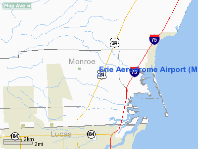
Location & QuickFacts
| FAA Information Effective: | 2008-09-25 |
| Airport Identifier: | M84 |
| Airport Status: | Operational |
| Longitude/Latitude: | 083-31-04.0000W/41-46-57.7000N
-83.517778/41.782694 (Estimated) |
| Elevation: | 605 ft / 184.40 m (Estimated) |
| Land: | 29 acres |
| From nearest city: | 1 nautical miles SW of Erie, MI |
| Location: | Monroe County, MI |
| Magnetic Variation: | 05W (1980) |
Owner & Manager
| Ownership: | Privately owned |
| Owner: | Howard J. Crowe |
| Address: | 9041 Telegraph Road
Temperance, MI 48182-9524 |
| Phone number: | 734-848-8590 |
| Manager: | Howard J. Crowe |
| Address: | 9041 Telegraph Road
Temperance, MI 48182-9524 |
| Phone number: | 734-848-8590 |
Airport Operations and Facilities
| Airport Use: | Open to public |
| Wind indicator: | Yes |
| Segmented Circle: | No |
| Control Tower: | No |
| Sectional chart: | Detroit |
| Region: | AGL - Great Lakes |
| Boundary ARTCC: | ZOB - Cleveland |
| Tie-in FSS: | LAN - Lansing |
| FSS Toll Free: | 1-800-WX-BRIEF |
| NOTAMs Facility: | LAN (NOTAM-d service avaliable) |
Airport Communications
Airport Services
Runway Information
Runway 18/36
| Dimension: | 2670 x 90 ft / 813.8 x 27.4 m |
| Surface: | TURF, Good Condition |
| |
Runway 18 |
Runway 36 |
| Longitude: | 083-31-04.3600W | 083-31-03.5500W |
| Latitude: | 41-47-10.8500N | 41-46-44.4700N |
| Traffic Pattern: | Left | Left |
| Displaced threshold: | 0.00 ft | 760.00 ft |
| Obstruction: | 90 ft trees, 2730.0 ft from runway, 30:1 slope to clear | 22 ft pline, 5.0 ft from runway
RWY 36 APCH RATIO 11:1 AT DSPLCD THLD OVER 73 FT TREE, 830 FT DSTC, 75 FT RIGHT. |
|
Radio Navigation Aids
| ID |
Type |
Name |
Ch |
Freq |
Var |
Dist |
| TCU | NDB | Tecumseh | | 239.00 | 04W | 22.3 nm |
| RYS | NDB | Grosse Ile | | 419.00 | 06W | 25.1 nm |
| ADG | NDB | Adrian | | 278.00 | 06W | 25.6 nm |
| USE | NDB | Fulton | | 375.00 | 05W | 29.5 nm |
| PCW | NDB | Port Clinton | | 423.00 | 06W | 33.2 nm |
| G | NDB | Golf | | 398.00 | 05W | 34.8 nm |
| FZI | NDB | Fostoria | | 379.00 | 05W | 36.1 nm |
| PT | NDB | Pelee Island | | 283.00 | 05W | 38.0 nm |
| VQ | NDB | Cargl | | 230.00 | 05W | 42.7 nm |
| QG | NDB | Windsor | | 353.00 | 06W | 43.1 nm |
| TII | NDB | Tiffin | | 269.00 | 05W | 43.5 nm |
| BNR | NDB | Benton Ridge | | 334.00 | 05W | 46.3 nm |
| BYN | NDB | Bryan | | 260.00 | 04W | 46.3 nm |
| DFI | NDB | Defiance | | 246.00 | 05W | 49.0 nm |
| PDR | NDB | Ottawa | | 233.00 | 05W | 49.7 nm |
| TOL | TACAN | Toledo | 072X | | 05W | 17.0 nm |
| MAH | VOR | Marathon | | 114.90 | 05W | 46.6 nm |
| VWV | VOR/DME | Waterville | 078X | 113.10 | 02W | 20.6 nm |
| DXO | VOR/DME | Detroit | 081X | 113.40 | 06W | 26.7 nm |
| YQG | VOR/DME | Windsor | 085X | 113.80 | 06W | 41.7 nm |
| SKY | VOR/DME | Sandusky | 029X | 109.20 | 04W | 44.1 nm |
| CRL | VORTAC | Carleton | 104X | 115.70 | 03W | 16.2 nm |
| SVM | VORTAC | Salem | 090X | 114.30 | 03W | 37.8 nm |
| YIP | VOT | Willow Run | | 112.00 | | 27.1 nm |
| DTW | VOT | Detroit Met Wayne | | 109.80 | | 27.6 nm |
| DET | VOT | Detroit City | | 111.60 | | 43.6 nm |
Remarks
- -5 FT DITCH NORTH OF RY 18; 55 FT L&R OF CNTRLN.
- RY 36 +34 FT POWER LINE 50 FT DSTC; MKD WITH ORANGE BALLS.
- PRVDD AREA 125 FT EITHER SIDE RY CNTRLN CLEAR OF OBSTN; OBSTN IN RY APCH SLP SFC REMOVED/LOWERED OR THR DSPLCD& MKD TO PRVD MIN 20:1 APCH CLNC OVER OBSTN.
Images and information placed above are from
http://www.airport-data.com/airport/M84/
We thank them for the data!
| General Info
|
| Country |
United States
|
| State |
MICHIGAN
|
| FAA ID |
M84
|
| Latitude |
41-46-59.169N
|
| Longitude |
083-31-00.764W
|
| Elevation |
605 feet
|
| Near City |
ERIE
|
We don't guarantee the information is fresh and accurate. The data may
be wrong or outdated.
For more up-to-date information please refer to other sources.
|
|


