 |
|
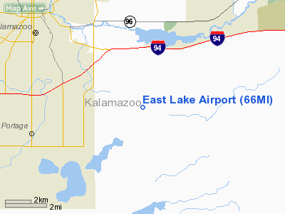
Location & QuickFacts
| FAA Information Effective: | 2008-09-25 |
| Airport Identifier: | 66MI |
| Airport Status: | Operational |
| Longitude/Latitude: | 085-29-04.0020W/42-13-42.1560N
-85.484445/42.228377 (Estimated) |
| Elevation: | 860 ft / 262.13 m (Estimated) |
| Land: | 0 acres |
| From nearest city: | 5 nautical miles SE of Kalamazoo, MI |
| Location: | Kalamazoo County, MI |
| Magnetic Variation: | 04W (1985) |
Owner & Manager
| Ownership: | Privately owned |
| Owner: | Clint Fleck
CO-OWNERS INCLUDE MR. JOHN BALKEMS, AND MRS. DONNA RHOADES. |
| Address: | 6262 S. 29th St
Scotts, MI 49088 |
| Phone number: | 616-382-6537 |
| Manager: | Clint Fleck |
| Address: | 6262 S.29th St.
Scotts, MI 49088 |
| Phone number: | 616-382-6537 |
Airport Operations and Facilities
| Airport Use: | Private |
| Wind indicator: | Yes |
| Segmented Circle: | No |
| Control Tower: | No |
| Landing fee charge: | No |
| Sectional chart: | Chicago |
| Region: | AGL - Great Lakes |
| Boundary ARTCC: | ZAU - Chicago |
| Tie-in FSS: | LAN - Lansing |
| FSS on Airport: | No |
| FSS Toll Free: | 1-800-WX-BRIEF |
Runway Information
Runway 17/35
| Dimension: | 2200 x 60 ft / 670.6 x 18.3 m |
| Surface: | TURF, |
| |
Runway 17 |
Runway 35 |
| Traffic Pattern: | Left | Left |
| Displaced threshold: | 300.00 ft | 520.00 ft |
| Obstruction: | 30 ft pline, 430.0 ft from runway | 60 ft silo, 925.0 ft from runway |
|
Radio Navigation Aids
| ID |
Type |
Name |
Ch |
Freq |
Var |
Dist |
| BT | NDB | Batol | | 272.00 | 04W | 15.6 nm |
| HAI | NDB | Three Rivers | | 407.00 | 02W | 16.9 nm |
| IRS | NDB | Sturgis | | 382.00 | 04W | 25.1 nm |
| ANQ | NDB | Angola | | 347.00 | 05W | 39.6 nm |
| HLM | NDB | Holland | | 233.00 | 03W | 45.3 nm |
| AZO | VOR/DME | Kalamazoo | 027X | 109.00 | 01W | 3.1 nm |
| ELX | VOR/DME | Keeler | 113X | 116.60 | 00E | 28.9 nm |
| PMM | VOR/DME | Pullman | 058X | 112.10 | 00E | 31.0 nm |
| GRR | VOR/DME | Grand Rapids | 106Y | 115.95 | 04W | 33.6 nm |
| LFD | VOR/DME | Litchfield | 049X | 111.20 | 05W | 33.6 nm |
| JXN | VOR/DME | Jackson | 033X | 109.60 | 05W | 45.7 nm |
| BTL | VORTAC | Battle Creek | 031X | 109.40 | 02W | 11.4 nm |
| LAN | VORTAC | Lansing | 045X | 110.80 | 05W | 45.6 nm |
| GIJ | VORTAC | Gipper | 101X | 115.40 | 00E | 46.4 nm |
| GSH | VORTAC | Goshen | 084X | 113.70 | 00E | 48.8 nm |
Remarks
- PROVIDED OBSTRUCTIONS IN APCH AREA ARE REMOVED/LOWERED OR THR DSPLCD TO PROVIDE 20:1 APCH CLEARANCE; OPNS ARE CONDUCTED EAST OF RWY 17/35.
Images and information placed above are from
http://www.airport-data.com/airport/66MI/
We thank them for the data!
| General Info
|
| Country |
United States
|
| State |
MICHIGAN
|
| FAA ID |
66MI
|
| Latitude |
42-13-42.156N
|
| Longitude |
085-29-04.002W
|
| Elevation |
860 feet
|
| Near City |
KALAMAZOO
|
We don't guarantee the information is fresh and accurate. The data may
be wrong or outdated.
For more up-to-date information please refer to other sources.
|
|


