 |
|
|
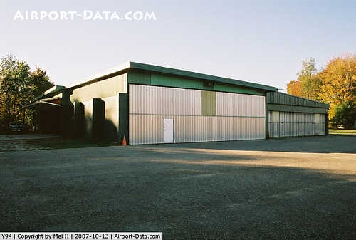 |
(Click on the photo to enlarge) |
|
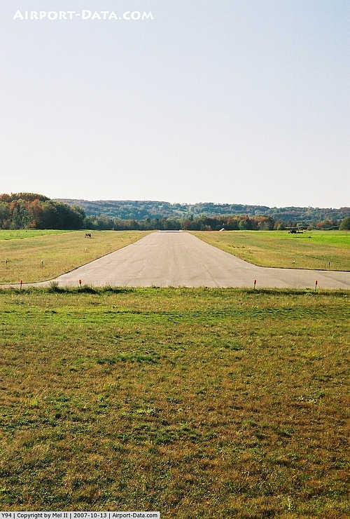 |
(Click on the photo to enlarge) |
Location & QuickFacts
| FAA Information Effective: | 2008-09-25 |
| Airport Identifier: | Y94 |
| Airport Status: | Operational |
| Longitude/Latitude: | 085-06-23.7200W/45-07-48.3250N
-85.106589/45.130090 (Estimated) |
| Elevation: | 642 ft / 195.68 m (Surveyed) |
| Land: | 257 acres |
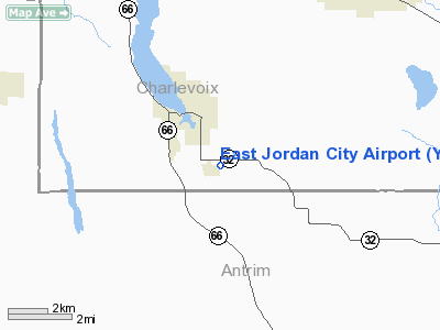
| From nearest city: | 2 nautical miles SE of East Jordan, MI |
| Location: | Charlevoix County, MI |
| Magnetic Variation: | 05W (1985) |
Owner & Manager
| Ownership: | Publicly owned |
| Owner: | City Of East Jordan |
| Address: | 201 Main St, P O Box 499
East Jordan, MI 49727-0499 |
| Phone number: | 231-536-3381 |
| Manager: | Dave White |
| Address: | 201 Main St
East Jordan, MI 49727 |
| Phone number: | 231-536-3381
AMGR RESIDENCE 231-536-7217. ASST AMGR RES 231-536-2756. |
Airport Operations and Facilities
| Airport Use: | Open to public |
| Wind indicator: | Yes |
| Segmented Circle: | Yes |
| Control Tower: | No |
| Lighting Schedule: | RDO-CTL
ACTVT MIRL RY 09/27, VASI RY 27 -122.8. |
| Landing fee charge: | No |
| Sectional chart: | Green Bay |
| Region: | AGL - Great Lakes |
| Boundary ARTCC: | ZMP - Minneapolis |
| Tie-in FSS: | LAN - Lansing |
| FSS on Airport: | No |
| FSS Toll Free: | 1-800-WX-BRIEF |
| NOTAMs Facility: | LAN (NOTAM-d service avaliable) |
Airport Communications
Airport Services
Runway Information
Runway 09/27
| Dimension: | 3250 x 50 ft / 990.6 x 15.2 m |
| Surface: | ASPH, Good Condition
RWY 18/36 SFC ROUGH WITH BARE SPOTS. |
| Edge Lights: | Medium |
| |
Runway 09 |
Runway 27 |
| Longitude: | 085-07-05.0400W | 085-06-19.7300W |
| Latitude: | 45-07-49.7100N | 45-07-48.5900N |
| Elevation: | 642.00 ft | 642.00 ft |
| Traffic Pattern: | Left | Left |
| Markings: | None,
RWY MARKINGS FADED | None, |
| Crossing Height: | 0.00 ft | 32.00 ft |
| Displaced threshold: | 0.00 ft | 125.00 ft |
| VASI: | | 2-box on left side |
| Visual Glide Angle: | 0.00° | 4.00° |
| Obstruction: | 10 ft road, 350.0 ft from runway, 15:1 slope to clear
APCH RATIO 35:1 TO THLD. | 15 ft road, 245.0 ft from runway, 3:1 slope to clear
APCH RATIO 20:1 AT DSPLCD THLD OVR +70 FT TREES, 1400 FT FM DSPLCD THLD 165 FT R.
+4 FT POST 175 FT DSTC 15 FT R. |
|
Runway 18/36
| Dimension: | 1800 x 120 ft / 548.6 x 36.6 m |
| Surface: | TURF, Poor Condition
RWY 18/36 SFC ROUGH WITH BARE SPOTS. |
| |
Runway 18 |
Runway 36 |
| Longitude: | 085-06-48.1400W | 085-06-48.1400W |
| Latitude: | 45-07-49.7600N | 45-07-33.2200N |
| Elevation: | 642.00 ft | 642.00 ft |
| Traffic Pattern: | Left | Left |
| Obstruction: | 40 ft trees, 1000.0 ft from runway, 70 ft left of centerline, 25:1 slope to clear | 40 ft trees, 0.0 ft from runway, 125 ft left of centerline |
|
Radio Navigation Aids
| ID |
Type |
Name |
Ch |
Freq |
Var |
Dist |
| BFA | NDB | Boyne Falls | | 263.00 | 06W | 8.1 nm |
| CVX | NDB | Charlevoix | | 392.00 | 05W | 12.4 nm |
| CXK | NDB | Clam Lake | | 251.00 | 05W | 15.0 nm |
| GYG | NDB | Grayling | | 359.00 | 06W | 25.7 nm |
| TV | NDB | Gwenn | | 365.00 | 05W | 27.5 nm |
| SJX | NDB | St James | | 382.00 | 05W | 38.9 nm |
| CGG | VOR | Grayling | | 109.80 | 06W | 31.4 nm |
| GLR | VOR/DME | Gaylord | 029X | 109.20 | 06W | 18.5 nm |
| TVC | VORTAC | Traverse City | 093X | 114.60 | 02W | 33.6 nm |
| PLN | VORTAC | Pellston | 055X | 111.80 | 06W | 35.4 nm |
Remarks
- BIRDS & DEER ON & INVOF ARPT.
- 1670 FT MSL TWR 3 MI NE.
- EXISTED PRIOR TO 1959.
Images and information placed above are from
http://www.airport-data.com/airport/Y94/
We thank them for the data!
| General Info
|
| Country |
United States
|
| State |
MICHIGAN
|
| FAA ID |
Y94
|
| Latitude |
45-07-48.325N
|
| Longitude |
085-06-23.720W
|
| Elevation |
642 feet
|
| Near City |
EAST JORDAN
|
We don't guarantee the information is fresh and accurate. The data may
be wrong or outdated.
For more up-to-date information please refer to other sources.
|
|


