 |
|
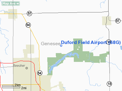
Location & QuickFacts
| FAA Information Effective: | 2008-09-25 |
| Airport Identifier: | 68G |
| Airport Status: | Operational |
| Longitude/Latitude: | 083-37-34.8410W/43-07-30.0940N
-83.626345/43.125026 (Estimated) |
| Elevation: | 773 ft / 235.61 m (Surveyed) |
| Land: | 30 acres |
| From nearest city: | 1 nautical miles NW of Genesee, MI |
| Location: | Genesee County, MI |
| Magnetic Variation: | 06W (1985) |
Owner & Manager
| Ownership: | Privately owned |
| Owner: | Norman Duford |
| Address: | 4287 E. Mt Morris Rd
Mount Morris, MI 48458 |
| Phone number: | 810-686-3190
RES PHONE 810-640-1453. OWNER RESIDES AT ARPT. |
| Manager: | Norman Duford |
| Address: | 4287 E. Mt Morris Rd
Mount Morris, MI 48458 |
| Phone number: | 810-686-3190 |
Airport Operations and Facilities
| Airport Use: | Open to public |
| Wind indicator: | Yes |
| Segmented Circle: | No |
| Control Tower: | No |
| Landing fee charge: | No |
| Sectional chart: | Detroit |
| Region: | AGL - Great Lakes |
| Boundary ARTCC: | ZOB - Cleveland |
| Tie-in FSS: | LAN - Lansing |
| FSS on Airport: | No |
| FSS Toll Free: | 1-800-WX-BRIEF |
| NOTAMs Facility: | LAN (NOTAM-d service avaliable) |
Airport Communications
Airport Services
| Airframe Repair: | NONE |
| Power Plant Repair: | NONE |
| Bottled Oxygen: | NONE |
| Bulk Oxygen: | NONE |
Runway Information
Runway 18/36
| Dimension: | 3068 x 100 ft / 935.1 x 30.5 m |
| Surface: | TURF, Poor Condition
RY 18/36 SURFACE ROUGH WITH IREG MOWING |
| |
Runway 18 |
Runway 36 |
| Longitude: | 083-37-37.2000W | 083-37-36.2000W |
| Latitude: | 43-07-47.5000N | 43-07-17.2000N |
| Traffic Pattern: | Left | Left |
| Displaced threshold: | 200.00 ft | 1020.00 ft |
| Obstruction: | 97 ft trees, 1750.0 ft from runway, 44 ft right of centerline, 18:1 slope to clear
APCH RATIO 20:1 AT DSPLCD THLDS. | 50 ft tree, 0.0 ft from runway, 60 ft left of centerline
RWY 36 APCH RATIO 0:1 AT DSPLCD THLD DUE TO +30 FT TREE 0 FT FROM THLD AND 70 FT L/R. |
|
Radio Navigation Aids
| ID |
Type |
Name |
Ch |
Freq |
Var |
Dist |
| HYX | NDB | Browne | | 385.00 | 06W | 21.0 nm |
| OZW | NDB | Howell | | 243.00 | 05W | 33.5 nm |
| MTC | TACAN | Selfridge | 064X | | 06W | 46.6 nm |
| MBS | VOR/DME | Saginaw | 076X | 112.90 | 03W | 31.4 nm |
| BAX | VOR/DME | Bad Axe | 019X | 108.20 | 05W | 48.5 nm |
| FNT | VORTAC | Flint | 116X | 116.90 | 06W | 10.9 nm |
| PSI | VORTAC | Pontiac | 047X | 111.00 | 03W | 25.8 nm |
| ECK | VORTAC | Peck | 087X | 114.00 | 07W | 40.6 nm |
| SVM | VORTAC | Salem | 090X | 114.30 | 03W | 43.1 nm |
Remarks
- SCT +10-45 FT TREES IN PRIM SFC.
- CROPS N OF RY 18/36 CAN GROW TO +8 FT DURING GROWING SEASON.
- VFR OPNS ONLY.
Images and information placed above are from
http://www.airport-data.com/airport/68G/
We thank them for the data!
| General Info
|
| Country |
United States
|
| State |
MICHIGAN
|
| FAA ID |
68G
|
| Latitude |
43-07-30.094N
|
| Longitude |
083-37-34.841W
|
| Elevation |
773 feet
|
| Near City |
GENESEE
|
We don't guarantee the information is fresh and accurate. The data may
be wrong or outdated.
For more up-to-date information please refer to other sources.
|
|


