 |
|
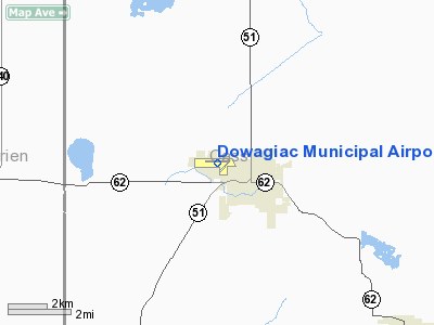
Dowagiac Municipal Airport |
| Dowagiac Municipal Airport |
| IATA: none – ICAO: none – FAA LID: C91 |
| Summary |
| Airport type |
Public |
| Operator |
City of Dowagiac |
| Location |
Dowagiac, Michigan |
| Elevation AMSL |
748 ft / 228 m |
| Coordinates |
41°59′57″N 86°8′9″W / 41.99917°N 86.13583°W / 41.99917; -86.13583Coordinates: 41°59′57″N 86°8′9″W / 41.99917°N 86.13583°W / 41.99917; -86.13583 |
| Runways |
| Direction |
Length |
Surface |
| ft |
m |
| 09/27 |
4700 |
1433 |
Asphalt |
| 04/22 |
2200 |
671 |
Sod |
Dowagiac Municipal Airport (FAA LID: C91) is a public airport owned and operated by the City of Dowagiac located 1m (1.6 km) northwest of Dowagiac, Michigan, United States. The airport in uncontrolled, and is used for general aviation purposes.
Additionally, radio controlled aircraft operations are permitted on the southeast side of runway 04/22.
On average, 70 aircraft operations occur each week, and 100% of the operations are general aviation. No commercial airline service is available. 18 aircraft are based on the field.
The above content comes from Wikipedia and is published under free licenses – click here to read more.
Location & QuickFacts
| FAA Information Effective: | 2008-09-25 |
| Airport Identifier: | C91 |
| Airport Status: | Operational |
| Longitude/Latitude: | 086-07-40.8450W/41-59-34.5630N
-86.128012/41.992934 (Estimated) |
| Elevation: | 748 ft / 227.99 m (Surveyed) |
| Land: | 80 acres |
| From nearest city: | 1 nautical miles NW of Dowagiac, MI |
| Location: | Cass County, MI |
| Magnetic Variation: | 01W (1980) |
Owner & Manager
| Ownership: | Publicly owned |
| Owner: | City Of Dowagiac |
| Address: | Po Box 430, 241 South Front
Dowagiac, MI 49047 |
| Phone number: | 269-782-8220 |
| Manager: | Gary Carlile |
| Address: | City Of Dowagiac, 241 S. Front St.
Dowagiac, MI 49047 |
| Phone number: | 269-782-3574 |
Airport Operations and Facilities
| Airport Use: | Open to public |
| Wind indicator: | Yes |
| Segmented Circle: | Yes |
| Control Tower: | No |
| Lighting Schedule: | DUSK-DAWN
ACTVT MIRL RY 09/27; PAPI RY 09 & VASI RY 27 & REIL RYS 09 & 27 - 122.8. |
| Beacon Color: | Clear-Green (lighted land airport) |
| Landing fee charge: | No |
| Sectional chart: | Chicago |
| Region: | AGL - Great Lakes |
| Traffic Pattern Alt: | 800 ft |
| Boundary ARTCC: | ZAU - Chicago |
| Tie-in FSS: | LAN - Lansing |
| FSS on Airport: | No |
| FSS Toll Free: | 1-800-WX-BRIEF |
| NOTAMs Facility: | LAN (NOTAM-d service avaliable) |
| Federal Agreements: | NGY |
Airport Communications
| CTAF: | 122.800 |
| Unicom: | 122.800 |
Airport Services
| Fuel available: | 100LL
SELF SVC FUEL AVBL 24 HR. |
Runway Information
Runway 04/22
| Dimension: | 2200 x 100 ft / 670.6 x 30.5 m |
| Surface: | TURF, Fair Condition
NUMEROUS CRACKS IN PVMNT. |
| |
Runway 04 |
Runway 22 |
| Longitude: | 086-07-31.7000W | 086-07-13.0440W |
| Latitude: | 41-59-20.4720N | 41-59-37.1630N |
| Alignment: | 40 | 127 |
| Traffic Pattern: | Left | Right |
| Displaced threshold: | 0.00 ft | 400.00 ft |
| Runway End Identifier: | No | No |
| Centerline Lights: | No | No |
| Touchdown Lights: | No | No |
| Obstruction: | 17 ft trees, 204.0 ft from runway, 125 ft right of centerline, 12:1 slope to clear | 65 ft tree, 900.0 ft from runway, 175 ft right of centerline, 13:1 slope to clear
APCH RATIO AT DSLPD THLD 20:1 BASED ON 65' TREE, 175R, 1300 DSTC. |
|
Runway 09/27
| Dimension: | 4700 x 100 ft / 1432.6 x 30.5 m |
| Surface: | ASPH, Poor Condition
NUMEROUS CRACKS IN PVMNT. |
| Weight Limit: | Single wheel: 30000 lbs.
Dual wheel: 60000 lbs. |
| Edge Lights: | Medium |
| |
Runway 09 |
Runway 27 |
| Longitude: | 086-08-20.6030W | 086-07-18.3630W |
| Latitude: | 41-59-37.3070N | 41-59-37.2430N |
| Elevation: | 736.00 ft | 746.00 ft |
| Alignment: | 90 | 127 |
| Traffic Pattern: | Left | Right |
| Markings: | Non-precision instrument, Poor Condition
RWY MKG FADED | Non-precision instrument, Poor Condition |
| Crossing Height: | 35.00 ft | 35.00 ft |
| VASI: | 4-light PAPI on left side | 4-light PAPI on left side |
| Visual Glide Angle: | 3.00° | 3.00° |
| Runway End Identifier: | Yes | Yes |
| Centerline Lights: | No | No |
| Touchdown Lights: | No | No |
| Obstruction: | 50 ft trees, 1900.0 ft from runway, 34:1 slope to clear | 68 ft trees, 1016.0 ft from runway, 250 ft right of centerline, 12:1 slope to clear |
|
Radio Navigation Aids
| ID |
Type |
Name |
Ch |
Freq |
Var |
Dist |
| HAI | NDB | Three Rivers | | 407.00 | 02W | 24.1 nm |
| IRS | NDB | Sturgis | | 382.00 | 04W | 32.9 nm |
| MGC | NDB | Michigan City | | 203.00 | 01W | 35.3 nm |
| IUL | NDB | La Porte | | 356.00 | 03W | 41.4 nm |
| VP | NDB | Sedly | | 212.00 | 02W | 46.8 nm |
| BT | NDB | Batol | | 272.00 | 04W | 47.5 nm |
| CPB | NDB | Culver | | 391.00 | 01W | 48.1 nm |
| HLM | NDB | Holland | | 233.00 | 03W | 48.3 nm |
| ELX | VOR/DME | Keeler | 113X | 116.60 | 00E | 9.1 nm |
| PMM | VOR/DME | Pullman | 058X | 112.10 | 00E | 28.5 nm |
| AZO | VOR/DME | Kalamazoo | 027X | 109.00 | 01W | 29.5 nm |
| OXI | VOR/DME | Knox | 103X | 115.60 | 00E | 46.6 nm |
| GIJ | VORTAC | Gipper | 101X | 115.40 | 00E | 16.0 nm |
| GSH | VORTAC | Goshen | 084X | 113.70 | 00E | 28.5 nm |
| BTL | VORTAC | Battle Creek | 031X | 109.40 | 02W | 43.4 nm |
Remarks
- NUMEROUS ULTRALIGHTS & ACFT WITH NO RADIO ON & INVOF ARPT.
- DEER ON & INVOF ARPT.
- MODEL RDO-CTL AIRCRAFT OPR E SIDE OF RWY 04/22
Images and information placed above are from
http://www.airport-data.com/airport/C91/
We thank them for the data!
| General Info
|
| Country |
United States
|
| State |
MICHIGAN
|
| FAA ID |
C91
|
| Latitude |
41-59-34.563N
|
| Longitude |
086-07-40.845W
|
| Elevation |
748 feet
|
| Near City |
DOWAGIAC
|
We don't guarantee the information is fresh and accurate. The data may
be wrong or outdated.
For more up-to-date information please refer to other sources.
|
|


