 |
|
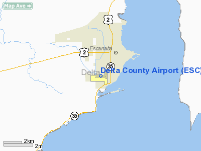
| Delta County Airport |
| IATA: ESC – ICAO: KESC |
| Summary |
| Airport type |
Public |
| Operator |
Delta County |
| Location |
Escanaba, Michigan |
| Elevation AMSL |
609 ft / 185.6 m |
| Coordinates |
45°43′22″N 87°05′37″W / 45.72278°N 87.09361°W / 45.72278; -87.09361Coordinates: 45°43′22″N 87°05′37″W / 45.72278°N 87.09361°W / 45.72278; -87.09361 |
| Runways |
| Direction |
Length |
Surface |
| ft |
m |
| 9/27 |
6,501 |
1,982 |
Asphalt |
| 18/36 |
5,000 |
1,524 |
Asphalt |
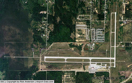
Delta County Airport (IATA: ESC, ICAO: KESC) is a public airport two miles (3 km) southwest of Escanaba, a city in Delta County, Michigan, USA. The airport covers 944 acres (382 hectares) and has two runways. It offers limited commercial service, which is subsidized by the Essential Air Service program.
Airlines and destinations
| Airlines |
Destinations |
| Delta Connection operated by Mesaba Airlines |
Detroit, Iron Mountain |
The above content comes from Wikipedia and is published under free licenses – click here to read more.
|
 |
(Click on the photo to enlarge) |
Location & QuickFacts
| FAA Information Effective: | 2008-09-25 |
| Airport Identifier: | ESC |
| Airport Status: | Operational |
| Longitude/Latitude: | 087-05-37.4000W/45-43-21.6000N
-87.093722/45.722667 (Estimated) |
| Elevation: | 609 ft / 185.62 m (Surveyed) |
| Land: | 944 acres |
| From nearest city: | 2 nautical miles SW of Escanaba, MI |
| Location: | Delta County, MI |
| Magnetic Variation: | 03W (1985) |
Owner & Manager
| Ownership: | Publicly owned |
| Owner: | Delta County |
| Address: | 310 Ludington St
Escanaba, MI 49829 |
| Phone number: | 906-789-5100 |
| Manager: | Connie Ness |
| Address: | Delta County Airport, 3300 Airport Road
Escanaba, MI 49829 |
| Phone number: | 906-786-4902 |
Airport Operations and Facilities
| Airport Use: | Open to public |
| Wind indicator: | Yes |
| Segmented Circle: | Yes |
| Control Tower: | No |
| Lighting Schedule: | DUSK-DAWN
ACTVT HIRL RY 09/27; MIRL RY 18/36; PAPI RYS 18 & 36; REIL RY 36 & MALSR RY 09 - CTAF. |
| Beacon Color: | Clear-Green (lighted land airport) |
| Landing fee charge: | Yes
FEE FOR MULTI ENGINE ACFT. |
| Sectional chart: | Green Bay |
| Region: | AGL - Great Lakes |
| Boundary ARTCC: | ZMP - Minneapolis |
| Tie-in FSS: | GRB - Green Bay |
| FSS on Airport: | No |
| FSS Toll Free: | 1-800-WX-BRIEF |
| NOTAMs Facility: | ESC (NOTAM-d service avaliable) |
| Certification type/date: | I A S 05/1973
ARPT CLSD TO UNSKED ACR OPNS WITH MORE THAN 30 PSGR SEATS EXCP PPR CALL AMGR 906-786-4902. ACR OPNS INVOLVING ACFT WITH MORE THAN 30 PSGR SEATS ARE NOT AUTHS IN EXCESS OF 15 MINS BEFORE OR AFTER SKED ARR/DEP TIME WO PRIOR COORDN WITH AMGR AND CFM THAT ARFF IS AVBL PRIOR TO LNDG/TKOF. |
| Federal Agreements: | NGY |
Airport Communications
| CTAF: | 122.800 |
| Unicom: | 122.800 |
Airport Services
| Fuel available: | 100LLA |
| Airframe Repair: | MINOR |
| Power Plant Repair: | MINOR |
| Bottled Oxygen: | NONE |
| Bulk Oxygen: | NONE |
Runway Information
Runway 09/27
| Dimension: | 6498 x 150 ft / 1980.6 x 45.7 m |
| Surface: | ASPH, Fair Condition |
| Surface Treatment: | Porous Friction Course |
| Weight Limit: | Single wheel: 80000 lbs.
Dual wheel: 120000 lbs.
Dual tandem wheel: 210000 lbs. |
| Edge Lights: | High |
| |
Runway 09 |
Runway 27 |
| Longitude: | 087-06-42.9680W | 087-05-11.3880W |
| Latitude: | 45-43-14.9596N | 45-43-13.9623N |
| Elevation: | 609.00 ft | 593.00 ft |
| Alignment: | 91 | 127 |
| ILS Type: | ILS
| |
| Traffic Pattern: | Left | Left |
| Markings: | Precision instrument, Fair Condition | Precision instrument, Fair Condition |
| Crossing Height: | 0.00 ft | 53.00 ft |
| VASI: | | 4-box on right side |
| Visual Glide Angle: | 0.00° | 3.00° |
| Approach lights: | MALSR | |
| Runway End Identifier: | No | Yes |
| Centerline Lights: | No | No |
| Touchdown Lights: | No | No |
| Obstruction: | 83 ft trees, 3300.0 ft from runway, 400 ft left of centerline, 37:1 slope to clear | 56 ft trees, 2100.0 ft from runway, 33:1 slope to clear |
|
Runway 18/36
| Dimension: | 5015 x 100 ft / 1528.6 x 30.5 m |
| Surface: | ASPH, Fair Condition |
| Surface Treatment: | Porous Friction Course |
| Weight Limit: | Single wheel: 40000 lbs.
Dual wheel: 60000 lbs. |
| Edge Lights: | Medium |
| |
Runway 18 |
Runway 36 |
| Longitude: | 087-05-11.1651W | 087-05-12.2664W |
| Latitude: | 45-43-55.6620N | 45-43-06.1506N |
| Elevation: | 607.00 ft | 592.00 ft |
| Alignment: | 127 | 1 |
| Traffic Pattern: | Left | Left |
| Markings: | Non-precision instrument, Good Condition | Non-precision instrument, Good Condition |
| Crossing Height: | 42.00 ft | 27.00 ft |
| VASI: | 4-light PAPI on left side | 4-light PAPI on left side |
| Visual Glide Angle: | 3.00° | 3.00° |
| Runway End Identifier: | | Yes |
| Centerline Lights: | No | No |
| Touchdown Lights: | No | No |
| Obstruction: | 53 ft trees, 1060.0 ft from runway, 16:1 slope to clear | 65 ft trees, 1725.0 ft from runway, 314 ft left of centerline, 23:1 slope to clear |
|
Radio Navigation Aids
| ID |
Type |
Name |
Ch |
Freq |
Var |
Dist |
| ESC | VOR/DME | Escanaba | 045X | 110.80 | 00E | 0.2 nm |
| MNM | VOR/DME | Menominee | 033X | 109.60 | 00E | 40.1 nm |
| SAW | VOR/DME | Sawyer | 118X | 117.10 | 04W | 40.3 nm |
| ISQ | VOR/DME | Schoolcraft County | 041X | 110.40 | 05W | 41.4 nm |
| IMT | VOR/DME | Iron Mountain | 049X | 111.20 | 02W | 43.1 nm |
Remarks
- DEER ON & INVOF ARPT.
- WATERFOWL & BIRDS ON & INVOF ARPT.
Images and information placed above are from
http://www.airport-data.com/airport/ESC/
We thank them for the data!
| General Info
|
| Country |
United States
|
| State |
MICHIGAN
|
| FAA ID |
ESC
|
| Latitude |
45-43-21.611N
|
| Longitude |
087-05-37.433W
|
| Elevation |
609 feet
|
| Near City |
ESCANABA
|
We don't guarantee the information is fresh and accurate. The data may
be wrong or outdated.
For more up-to-date information please refer to other sources.
|
|


