 |
|
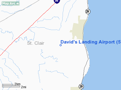
Location & QuickFacts
| FAA Information Effective: | 2008-09-25 |
| Airport Identifier: | 5Y5 |
| Airport Status: | Operational |
| Longitude/Latitude: | 082-32-11.3000W/42-47-52.0000N
-82.536472/42.797778 (Estimated) |
| Elevation: | 615 ft / 187.45 m (Estimated) |
| Land: | 51 acres |
| From nearest city: | 3 nautical miles SW of St Clair, MI |
| Location: | St Clair County, MI |
| Magnetic Variation: | 06W (1985) |
Owner & Manager
| Ownership: | Privately owned |
| Owner: | Dave Shirey |
| Address: | 5599 St Clair Highway
China Township, MI 48054 |
| Phone number: | 810-326-2989 |
| Manager: | Dave Shirey |
| Address: | 5599 St Clair Highway
China Township, MI 48054 |
| Phone number: | 810-326-2989 |
Airport Operations and Facilities
| Airport Use: | Open to public |
| Wind indicator: | Yes |
| Segmented Circle: | No |
| Control Tower: | No |
| Landing fee charge: | No |
| Sectional chart: | Detroit |
| Region: | AGL - Great Lakes |
| Boundary ARTCC: | ZOB - Cleveland |
| Tie-in FSS: | LAN - Lansing |
| FSS on Airport: | No |
| FSS Toll Free: | 1-800-WX-BRIEF |
| NOTAMs Facility: | LAN (NOTAM-d service avaliable) |
Airport Communications
Airport Services
| Airframe Repair: | NONE |
| Power Plant Repair: | NONE |
Runway Information
Runway 18/36
| Dimension: | 2500 x 100 ft / 762.0 x 30.5 m |
| Surface: | TURF, Good Condition |
| |
Runway 18 |
Runway 36 |
| Longitude: | 082-32-11.9900W | 082-32-10.6500W |
| Latitude: | 42-48-04.3700N | 42-47-39.6900N |
| Traffic Pattern: | Left | Left |
| Displaced threshold: | 1100.00 ft | 0.00 ft |
| Obstruction: | 30 ft pline, 177.0 ft from runway, 5:1 slope to clear
APCH RATIO 21:1 OVER 62 FT TREES, 1302 FT DSTC. | 50 ft trees, 0.0 ft from runway, 110 ft right of centerline |
|
Radio Navigation Aids
| ID |
Type |
Name |
Ch |
Freq |
Var |
Dist |
| ZR | NDB | Sarnia | | 404.00 | 06W | 15.9 nm |
| VQ | NDB | Cargl | | 230.00 | 05W | 32.3 nm |
| QG | NDB | Windsor | | 353.00 | 06W | 32.6 nm |
| 4L | NDB | Chatham | | 236.00 | 06W | 35.6 nm |
| G | NDB | Golf | | 398.00 | 05W | 40.3 nm |
| MTC | TACAN | Selfridge | 064X | | 06W | 17.1 nm |
| YQG | VOR/DME | Windsor | 085X | 113.80 | 06W | 35.4 nm |
| ECK | VORTAC | Peck | 087X | 114.00 | 07W | 28.7 nm |
| PSI | VORTAC | Pontiac | 047X | 111.00 | 03W | 44.4 nm |
| DET | VOT | Detroit City | | 111.60 | | 31.7 nm |
Remarks
- ARPT CLSD DEC-MAR & WHEN SNOW COVERED.
- 100 FT POWERLINE 5/8 MILE S OF RY 36 .
- -4 FT DITCH 10 FT W OF RWY.
- PRVDD CLEAR OBSTRACLE FREE ZONE AND OBSTN REMOVED/LOWERED OR THLD DSPLCD TO PROVIDE CLEAR 20:1 APCH.
Images and information placed above are from
http://www.airport-data.com/airport/5Y5/
We thank them for the data!
| General Info
|
| Country |
United States
|
| State |
MICHIGAN
|
| FAA ID |
5Y5
|
| Latitude |
42-47-50.115N
|
| Longitude |
082-32-14.691W
|
| Elevation |
615 feet
|
| Near City |
ST CLAIR
|
We don't guarantee the information is fresh and accurate. The data may
be wrong or outdated.
For more up-to-date information please refer to other sources.
|
|


