 |
|
| Custer Airport |
 |
| IATA: none – ICAO: KTTF – FAA LID: TTF |
| Summary |
| Airport type |
Public |
| Owner |
City of Monroe |
| Operator |
Cleveland ARTCC |
| Location |
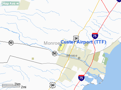
2800 North Custer Road
Monroe, Michigan 48162 |
| Elevation AMSL |
616 ft / 188 m |
| Coordinates |
41°55′59″N 83°26′10″W / 41.933°N 83.436°W / 41.933; -83.436 (Custer Airport)Coordinates: 41°55′59″N 83°26′10″W / 41.933°N 83.436°W / 41.933; -83.436 (Custer Airport) |
| Runways |
| Direction |
Length |
Surface |
| ft |
m |
| 3L/21R |
4,997 |
1,523 |
Asphalt |
| Statistics (2007) |
| Aircraft operations |
11,389 |
| Based aircraft |
45 |
| Source: Federal Aviation Administration |
Custer Airport (ICAO: KTTF, FAA LID: TTF), sometimes referred to as Monroe Custer Airport, is a city-owned public airport located in the city of Monroe in Monroe County, Michigan. The airport opened in November 1946 and was named for George Armstrong Custer, who spent much of his early life in Monroe.
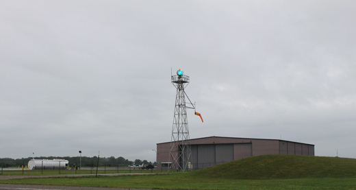 | |
Light beacon, hangar & tarmac |
Custer Airport is owned by the city of Monroe and is financially supported through hangar rentals, landing fees, and fuel sales. It is located on North Custer Road (formerly designated as M-130) about two miles (3.2 km) northwest of Monroe's downtown area. The airport property itself — occupying 158 acres (63 ha) — is an exclave of the city limits and is separated by a one-quarter mile (0.4 km) wide undeveloped residential area belonging to Frenchtown Charter Township. Since the city owns the airport, the area it occupies was incorporated into the city limits. Munson Park, the largest public recreation park in Monroe, occupies the land immediately east of the airport. The River Raisin is just south of the airport, and farmland surrounds the airport to the west and north.
Facilities
The airport has one 4997 × 100 feet (1523 × 30 m) asphalt runway (3-21) with a full length taxiwayy. Both are illuminated with high intensity lighting, runway 21 has runway end identifiers (REILS) and both runways have visual approach slope indicators (VASI). The airport has no regularly scheduled flights or arrivals. As a general aviation airport, it is mainly used by private pilots for personal and business use, as well as a variety of chartered aircraft bringing people in to do business in Monroe County. Custer Airport is able to accommodate a large variety of aircraft, including single engine aircraft, twin engine aircraft, and business jets such as the Cessna Citation and Learjet. The airport has personal hangars that house approximately 45 airplanes and a large hangar that houses several corporate aircraft as well as the Monroe Aviation School of Flight and Monroe Aviation Aircraft Maintenance. In addition, a Michigan Civil Air Patrol aircraft is stationed at the airport. The Monroe County Sheriff Department maintains hangars for its helicopter operations. The airport has 100LL fuel available 24 hours through self-serve as well as full-service Jet-A fuel. In 2007, there was an average of 65 flights per day for a yearly total of 11,389.
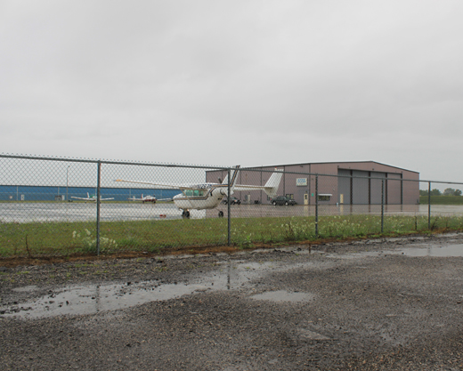 | |
Tarmac & hangar/terminal |
The airport operates continuously and is staffed from 8–5 with after-hours services available through prior arrangement. Custer Airport has no control tower, and instrument traffic is handled by the Cleveland Air Route Traffic Control Center (ZOB) in coordination with the Detroit Approach and Departure Control. The nearest neighboring airports that can accommodate flights from Custer Airport are Lenawee County Airport to the west, Toledo Suburban Airport to the southwest, and Grosse Ile Municipal Airport to the north. Detroit Metropolitan Wayne County Airport and Toledo Express Airport are within close proximity and are used regularly by pilots departing Monroe for both business and training purposes..
Following the September 11 attacks in 2001, local concerns were raised that Custer Airport could be shut down by government intervention because of the airport's close proximity to a nuclear power plant. Custer Airport is located approximately 9½ miles (15.3 km) from the Enrico Fermi Nuclear Generating Station in nearby Frenchtown Charter Township. It was suggested that airports within 10 miles of a nuclear power plant be shut down until tighter security policies and government mandates could be enacted by both the airports and nuclear power plants. Custer Airport was not affected, because security was deemed more than adequate.
The above content comes from Wikipedia and is published under free licenses – click here to read more.
Location & QuickFacts
| FAA Information Effective: | 2008-09-25 |
| Airport Identifier: | TTF |
| Airport Status: | Operational |
| Longitude/Latitude: | 083-26-04.8000W/41-56-23.6000N
-83.434667/41.939889 (Estimated) |
| Elevation: | 616 ft / 187.76 m (Surveyed) |
| Land: | 158 acres |
| From nearest city: | 2 nautical miles NW of Monroe, MI |
| Location: | Monroe County, MI |
| Magnetic Variation: | 05W (1980) |
Owner & Manager
| Ownership: | Publicly owned |
| Owner: | City Of Monroe |
| Address: | 2800 N Custer Rd
Monroe, MI 48162 |
| Phone number: | 734-241-7110 |
| Manager: | Scott Davidson |
| Address: | 222 Jones Ave
Monroe, MI 48161 |
| Phone number: | 734-241-6800
ASST MGR PHONE 734-384-9616. |
Airport Operations and Facilities
| Airport Use: | Open to public |
| Wind indicator: | Yes |
| Segmented Circle: | Yes |
| Control Tower: | No |
| Lighting Schedule: | DUSK-DAWN
ACTVT MIRL RY 03/21, REIL RY 21, VASI RY 03 & PAPI RY 21 - CTAF. |
| Beacon Color: | Clear-Green (lighted land airport) |
| Landing fee charge: | No |
| Sectional chart: | Detroit |
| Region: | AGL - Great Lakes |
| Boundary ARTCC: | ZOB - Cleveland |
| Tie-in FSS: | LAN - Lansing |
| FSS on Airport: | No |
| FSS Toll Free: | 1-800-WX-BRIEF |
| NOTAMs Facility: | TTF (NOTAM-d service avaliable) |
| Federal Agreements: | NGRY |
Airport Communications
| CTAF: | 122.700 |
| Unicom: | 122.700 |
Airport Services
| Fuel available: | 100LLA |
| Airframe Repair: | MAJOR |
| Power Plant Repair: | MAJOR |
| Bottled Oxygen: | NONE |
| Bulk Oxygen: | HIGH |
Runway Information
Runway 03/21
| Dimension: | 4997 x 100 ft / 1523.1 x 30.5 m |
| Surface: | ASPH, Fair Condition |
| Weight Limit: | Single wheel: 60000 lbs.
Dual wheel: 80000 lbs. |
| Edge Lights: | Medium |
| |
Runway 03 |
Runway 21 |
| Longitude: | 083-26-17.4488W | 083-25-52.1548W |
| Latitude: | 41-56-00.8395N | 41-56-46.4457N |
| Elevation: | 611.00 ft | 615.00 ft |
| Alignment: | 22 | 127 |
| Traffic Pattern: | Left | Left |
| Markings: | Non-precision instrument, Fair Condition
RY 3/21 MARKINGS FADED | Non-precision instrument, Fair Condition
RY 3/21 MARKINGS FADED |
| Crossing Height: | 49.00 ft | 42.00 ft |
| VASI: | 2-box on left side | 2-light PAPI on left side |
| Visual Glide Angle: | 4.00° | 3.50° |
| Runway End Identifier: | No | Yes |
| Centerline Lights: | No | No |
| Touchdown Lights: | No | No |
| Obstruction: | 78 ft trees, 1772.0 ft from runway, 220 ft left of centerline, 20:1 slope to clear | 80 ft trees, 3400.0 ft from runway, 40:1 slope to clear |
|
Radio Navigation Aids
| ID |
Type |
Name |
Ch |
Freq |
Var |
Dist |
| RYS | NDB | Grosse Ile | | 419.00 | 06W | 15.9 nm |
| TCU | NDB | Tecumseh | | 239.00 | 04W | 20.7 nm |
| G | NDB | Golf | | 398.00 | 05W | 25.1 nm |
| ADG | NDB | Adrian | | 278.00 | 06W | 29.1 nm |
| VQ | NDB | Cargl | | 230.00 | 05W | 32.9 nm |
| QG | NDB | Windsor | | 353.00 | 06W | 33.8 nm |
| PT | NDB | Pelee Island | | 283.00 | 05W | 35.6 nm |
| PCW | NDB | Port Clinton | | 423.00 | 06W | 35.9 nm |
| USE | NDB | Fulton | | 375.00 | 05W | 37.1 nm |
| FZI | NDB | Fostoria | | 379.00 | 05W | 45.2 nm |
| OZW | NDB | Howell | | 243.00 | 05W | 48.4 nm |
| TOL | TACAN | Toledo | 072X | | 05W | 26.5 nm |
| MTC | TACAN | Selfridge | 064X | | 06W | 48.5 nm |
| DXO | VOR/DME | Detroit | 081X | 113.40 | 06W | 16.7 nm |
| VWV | VOR/DME | Waterville | 078X | 113.10 | 02W | 30.8 nm |
| YQG | VOR/DME | Windsor | 085X | 113.80 | 06W | 32.8 nm |
| SKY | VOR/DME | Sandusky | 029X | 109.20 | 04W | 46.3 nm |
| JXN | VOR/DME | Jackson | 033X | 109.60 | 05W | 49.5 nm |
| CRL | VORTAC | Carleton | 104X | 115.70 | 03W | 6.6 nm |
| SVM | VORTAC | Salem | 090X | 114.30 | 03W | 29.1 nm |
| PSI | VORTAC | Pontiac | 047X | 111.00 | 03W | 45.9 nm |
| DTW | VOT | Detroit Met Wayne | | 109.80 | | 17.6 nm |
| YIP | VOT | Willow Run | | 112.00 | | 18.1 nm |
| DET | VOT | Detroit City | | 111.60 | | 33.6 nm |
Remarks
- GCO AVBL ON FREQ 121.725 THRU DTW CD & FLT SVCS.
Images and information placed above are from
http://www.airport-data.com/airport/TTF/
We thank them for the data!
| General Info
|
| Country |
United States
|
| State |
MICHIGAN
|
| FAA ID |
TTF
|
| Latitude |
41-56-23.663N
|
| Longitude |
083-26-04.859W
|
| Elevation |
616 feet
|
| Near City |
MONROE
|
We don't guarantee the information is fresh and accurate. The data may
be wrong or outdated.
For more up-to-date information please refer to other sources.
|
|


