 |
|
Coleman A. Young Municipal Airport |
Coleman A. Young International Airport
Coleman A. Young Municipal Airport
Detroit City Airport |
| IATA: DET – ICAO: KDET – FAA LID: DET |
| Summary |
| Airport type |
Public |
| Owner |
City of Detroit |
| Serves |
Detroit, Michigan |
| Elevation AMSL |
626 ft / 191 m |
| Coordinates |
42°24′33″N 083°00′36″W / 42.40917°N 83.01°W / 42.40917; -83.01 |
| Runways |
| Direction |
Length |
Surface |
| ft |
m |
| 15/33 |
5,090 |
1,551 |
Asphalt |
| 7/25 |
4,025 |
1,227 |
Asphalt |
| Statistics (2007) |
| Aircraft operations |
77,571 |
| Based aircraft |
97 |
| Sources: Airport and FAA |
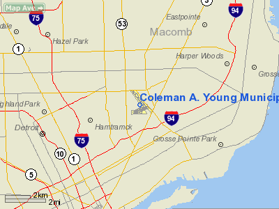
Coleman A. Young International Airport (IATA: DET, ICAO: KDET, FAA LID: DET), also known as Coleman A. Young Municipal Airport, is a public use airport located five nautical miles (9 km) northeast of the central business district of Detroit, in Wayne County, Michigan, United States. It is owned by the City of Detroit and was formerly known as Detroit City Airport.
The airport was once served by Southwest Airlines. and Chautauqua Airlines which left after less than one year of service. Spirit Airlines planned service to the airport using McDonnell-Douglas DC-9 aircraft in 1995, but the service never began. Pro Air, a commercial passenger airline, was based at the airport and grounded by the FAA due to poor maintenance performance. The airport currently has no scheduled passenger airline service.
The airport's passenger terminal is also operated by the US Customs department, which serves private and cargo airplanes.
The 53,000-square-foot (4,900 m) passenger terminal includes space for restaurants, retail concessions, car rental facilities, airline offices, baggage pick-up and claim areas, boarding areas and passenger lounges. The airport has three 1,000 space parking lots. Former airline service
The following airlines served Detroit City Airport:
- Wright Airlines (1975–1985)
- Northwest Airlink (1985–1988)
- Comair (1987–1991)
- Southwest Airlines (1988–1993)
- Direct Air (1988–1990)
- Northcoast Executive Airlines (1988–1990)
- Continental Express (1988–1991)
- Central State Airlines (1989–1990)
- Air Alpha (1991)
- USAir Express (1993–1994)
- Pro Air (1997–2000)
Facilities and aircraft
Coleman A. Young Municipal Airport covers an area of 264 acres (107 ha) at an elevation of 626 feet (191 m) above mean sea level. It has two asphalt paved runways: 15/33 is 5,090 by 100 feet (1,550 × 30 m) and 7/25 is 4,025 by 100 feet (1,227 × 30 m).
For the 12-month period ending December 31, 2007, the airport had 77,571 aircraft operations, an average of 212 per day: 88% general aviation and 11% air taxi and 1% military. At that time there were 97 aircraft based at this airport: 84% single-engine, 11% multi-engine, 4% jet and 1% ultralight.
Name: Coleman A Young Municipal Airport ('Detroit City')
IATA: DET
ICAO: KDET
Detroit , Michigan United States
Latitude: 42°24' 33" N
Longitude: 83°0' 35" W
Elevation: 626
Runway Length: 5090 Feet
Runway Length: 4025 Feet
Coordinates: 42°24'32"N 83°0'37"W
http://wikimapia.org/ - Detroit City Airport
The above content comes from Wikipedia and is published under free licenses – click here to read more.
|
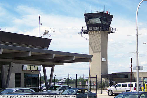 |
(Click on the photo to enlarge) |
|
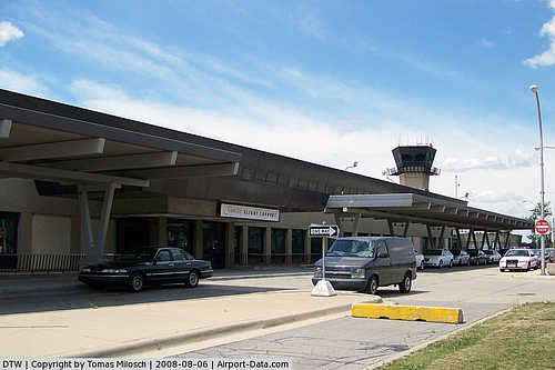 |
(Click on the photo to enlarge) |
Location & QuickFacts
| FAA Information Effective: | 2008-09-25 |
| Airport Identifier: | DET |
| Airport Status: | Operational |
| Longitude/Latitude: | 083-00-35.5000W/42-24-33.1000N
-83.009861/42.409194 (Estimated) |
| Elevation: | 626 ft / 190.80 m (Surveyed) |
| Land: | 264 acres |
| From nearest city: | 5 nautical miles NE of Detroit, MI |
| Location: | Wayne County, MI |
| Magnetic Variation: | 05W (1980) |
Owner & Manager
| Ownership: | Publicly owned |
| Owner: | City Of Detroit |
| Address: | 11499 Conner Ave
Detroit, MI 48213 |
| Phone number: | 313-267-6083 |
| Manager: | Delbert Brown |
| Address: | 11201 Conner Ave
Detroit, MI 48213 |
| Phone number: | 313-852-6400 X11 |
Airport Operations and Facilities
| Airport Use: | Open to public |
| Wind indicator: | Yes |
| Segmented Circle: | No |
| Control Tower: | Yes |
| Lighting Schedule: | DUSK-DAWN |
| Beacon Color: | Clear-Green (lighted land airport) |
| Landing fee charge: | Yes
LNDG FEE FOR ACFT 6000 LBS OR MORE. |
| Sectional chart: | Detroit |
| Region: | AGL - Great Lakes |
| Boundary ARTCC: | ZOB - Cleveland |
| Tie-in FSS: | LAN - Lansing |
| FSS on Airport: | No |
| FSS Toll Free: | 1-800-WX-BRIEF |
| NOTAMs Facility: | DET (NOTAM-d service avaliable) |
| Certification type/date: | IV A S 08/200 |
| Federal Agreements: | NGY |
Airport Communications
Airport Services
| Fuel available: | 100LLA |
| Airframe Repair: | MAJOR |
| Power Plant Repair: | MAJOR |
| Bottled Oxygen: | HIGH |
| Bulk Oxygen: | HIGH/LOW |
Runway Information
Runway 07/25
| Dimension: | 4025 x 100 ft / 1226.8 x 30.5 m |
| Surface: | ASPH, Fair Condition |
| Weight Limit: | Single wheel: 12500 lbs. |
| Edge Lights: | Medium
HIRL STEP 5 OTS INDEFLY. |
| |
Runway 07 |
Runway 25 |
| Longitude: | 083-00-56.6590W | 083-00-08.7350W |
| Latitude: | 42-24-10.3560N | 42-24-28.2160N |
| Elevation: | 626.00 ft | 622.00 ft |
| Alignment: | 63 | 127 |
| Traffic Pattern: | Left | Left |
| Markings: | Basic, Good Condition | Basic, Good Condition |
| Crossing Height: | 0.00 ft | 40.00 ft |
| Displaced threshold: | 715.00 ft | 716.00 ft |
| VASI: | | 4-light PAPI on left side |
| Visual Glide Angle: | 0.00° | 4.00° |
| Runway End Identifier: | No | No |
| Centerline Lights: | No | No |
| Touchdown Lights: | No | No |
| Obstruction: | 25 ft rr, 190.0 ft from runway, 25 ft right of centerline
RWY 07 APCH RATIO 26:1 TO DSPLCD THR, +73' TREES 1905' DSTC.
PLINE/BLDG 200 FT FM THLD, FENCE 88 FT FM THR, RR 0-200 FT FM THLD. | 32 ft pole, 226.0 ft from runway, 125 ft left of centerline
APCH RATIO 29:1 TO DSPLCD THR.
RY 25 ROAD & FENCE 200 FT FM THLD. |
|
Runway 15/33
| Dimension: | 5090 x 100 ft / 1551.4 x 30.5 m |
| Surface: | ASPH, Good Condition |
| Surface Treatment: | Saw-cut or plastic Grooved |
| Weight Limit: | Single wheel: 75000 lbs.
Dual wheel: 135000 lbs. |
| Edge Lights: | High
HIRL STEP 5 OTS INDEFLY. |
| |
Runway 15 |
Runway 33 |
| Longitude: | 083-00-58.4550W | 083-00-17.9300W |
| Latitude: | 42-25-04.6720N | 42-24-24.3430N |
| Elevation: | 624.00 ft | 625.00 ft |
| Alignment: | 127 | 127 |
| ILS Type: | ILS
| ILS
|
| Traffic Pattern: | Left | Left |
| Markings: | Precision instrument, Good Condition | Precision instrument, Good Condition |
| Crossing Height: | 56.00 ft | 49.00 ft |
| VASI: | 4-box on right side
RY 15 VASI OTS INDEFLY. | 4-light PAPI on left side |
| Visual Glide Angle: | 3.00° | 3.00° |
| Runway End Identifier: | Yes | Yes
REIL OTS INDEFLY. |
| Touchdown Lights: | No | No |
| Obstruction: | 70 ft trees, 450.0 ft from runway, 458 ft right of centerline, 3:1 slope to clear
FENCE; TREES 0-200 FT FM THLD 350 FT R OF CNTRLN. | 60 ft trees, 2180.0 ft from runway, 33:1 slope to clear |
|
Radio Navigation Aids
| ID |
Type |
Name |
Ch |
Freq |
Var |
Dist |
| VQ | NDB | Cargl | | 230.00 | 05W | 4.0 nm |
| QG | NDB | Windsor | | 353.00 | 06W | 8.5 nm |
| G | NDB | Golf | | 398.00 | 05W | 10.1 nm |
| RYS | NDB | Grosse Ile | | 419.00 | 06W | 19.6 nm |
| PT | NDB | Pelee Island | | 283.00 | 05W | 40.8 nm |
| 4L | NDB | Chatham | | 236.00 | 06W | 41.8 nm |
| TCU | NDB | Tecumseh | | 239.00 | 04W | 44.8 nm |
| OZW | NDB | Howell | | 243.00 | 05W | 45.4 nm |
| ZR | NDB | Sarnia | | 404.00 | 06W | 46.9 nm |
| MTC | TACAN | Selfridge | 064X | | 06W | 14.6 nm |
| YQG | VOR/DME | Windsor | 085X | 113.80 | 06W | 12.5 nm |
| DXO | VOR/DME | Detroit | 081X | 113.40 | 06W | 19.8 nm |
| SVM | VORTAC | Salem | 090X | 114.30 | 03W | 25.9 nm |
| PSI | VORTAC | Pontiac | 047X | 111.00 | 03W | 29.0 nm |
| CRL | VORTAC | Carleton | 104X | 115.70 | 03W | 29.5 nm |
| FNT | VORTAC | Flint | 116X | 116.90 | 06W | 46.7 nm |
| DET | VOT | Detroit City | | 111.60 | | 0.4 nm |
| DTW | VOT | Detroit Met Wayne | | 109.80 | | 19.2 nm |
| YIP | VOT | Willow Run | | 112.00 | | 25.1 nm |
Remarks
- LOAD/UNLOADING CLASS A XPLOS OR POISONS NOT PERMITTED, PPR FOR CLASS B & C XPLOS.
- DUE NOISE ABATEMENT RQRMTS JETS & ACFT OVER 12500 GWT MUST USE RWY 15/33 EXCP WHEN WINDS EXCEED 25 KTS THEN 7/25 AVBL.
- BIRDS ON & INVOF ARPT.
- UNLIGHTED TWR 275' AGL 1 MILE WSW.
- TWY 'D1' CLSD INDEFLY.
Images and information placed above are from
http://www.airport-data.com/airport/DET/
We thank them for the data!
| General Info
|
| Country |
United States
|
| State |
MICHIGAN
|
| ICAO ID |
KDET
|
| FAA ID |
DET
|
| Time |
UTC-5(-4DT)
|
| Latitude |
42.409195
42° 24' 33.10" N
|
| Longitude |
-83.009861
083° 00' 35.50" W
|
| Elevation |
626 feet
191 meters
|
| Type |
Civil
|
| Magnetic Variation |
007° W (01/06)
|
| Beacon |
Yes
|
| Operating Agency |
U.S.CIVIL AIRPORT WHEREIN PERMIT COVERS USE BY TRANSIT MILITARY AIRCRAFT
|
| International Clearance Status |
Airport of Entry
|
| Daylight Saving Time |
Second Sunday in March at 0200 to first Sunday in November at 0200 local time (Exception Arizona and that portion of Indiana in the Eastern Time Zone)
|
We don't guarantee the information is fresh and accurate. The data may
be wrong or outdated.
For more up-to-date information please refer to other sources.
|
|


