 |
|
| Clare Municipal Airport |
 |
| IATA: none – ICAO: none – FAA LID: 48D |
| Summary |
| Airport type |
Public |
| Owner |
City of Clare |
| Location |
Clare, Michigan |
| Elevation AMSL |
857 ft / 261 m |
| Coordinates |
43°50′04″N 084°44′25″W / 43.83444°N 84.74028°W / 43.83444; -84.74028 |
| Website |
www.clare48d.com |
| Runways |
| Direction |
Length |
Surface |
| ft |
m |
| 4/22 |
3,500 |
1,067 |
Asphalt |
| 9/27 |
2,500 |
762 |
Asphalt |
| Statistics (2005) |
| Aircraft operations |
5,384 |
| Based aircraft |
22 |
| Source: Federal Aviation Administration |
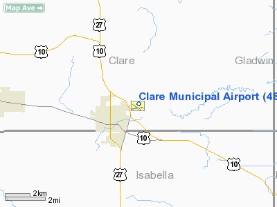
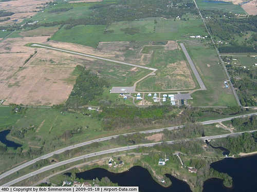
Clare Municipal Airport (FAA LID: 48D) is a public airport located one mile (2 km) east of downtown Clare, a city in Clare County, Michigan, United States. The airport became active in 1941. It serves general aviation for Clare and the surrounding area. There is no scheduled air service.
Facilities and aircraft
Clare Municipal Airport covers an area of 200 acres (81 ha) which contains two asphalt paved runways: 4/22 measuring 3,500 x 75 ft (1,067 x 23 m) and 9/27 measuring 2,500 x 75 ft (762 x 23 m).
For the 12-month period ending December 31, 2005, the airport had 5,384 general aviation aircraft operations, an average of 14 per day. There are 22 aircraft based at this airport: 91% single-engine and 9% multi-engine.
The above content comes from Wikipedia and is published under free licenses – click here to read more.
|
 |
(Click on the photo to enlarge) |
Location & QuickFacts
| FAA Information Effective: | 2008-09-25 |
| Airport Identifier: | 48D |
| Airport Status: | Operational |
| Longitude/Latitude: | 084-44-24.5570W/43-50-04.1340N
-84.740155/43.834482 (Estimated) |
| Elevation: | 857 ft / 261.21 m (Surveyed) |
| Land: | 200 acres |
| From nearest city: | 1 nautical miles E of Clare, MI |
| Location: | Clare County, MI |
| Magnetic Variation: | 05W (1995) |
Owner & Manager
| Ownership: | Publicly owned |
| Owner: | Ken Hibl |
| Address: | 202 W 5th St
Clare, MI 48617-1490 |
| Phone number: | 989-386-7541 |
| Manager: | Richard Acker |
| Address: | 202 W 5th St
Clare, MI 48617-1490 |
| Phone number: | 989-386-0445 |
Airport Operations and Facilities
| Airport Use: | Open to public |
| Wind indicator: | Yes |
| Segmented Circle: | Yes |
| Control Tower: | No |
| Lighting Schedule: | DUSK-DAWN
ACTVT MIRL RYS 04/22,09/27,REIL RYS 04 & 22 & PAPI RY 22 - CTAF. |
| Beacon Color: | Clear-Green (lighted land airport) |
| Landing fee charge: | No |
| Sectional chart: | Detroit |
| Region: | AGL - Great Lakes |
| Boundary ARTCC: | ZMP - Minneapolis |
| Responsible ARTCC: | ZOB - Cleveland |
| Tie-in FSS: | LAN - Lansing |
| FSS on Airport: | No |
| FSS Toll Free: | 1-800-WX-BRIEF |
| NOTAMs Facility: | LAN (NOTAM-d service avaliable) |
| Federal Agreements: | N1 |
Airport Communications
| CTAF: | 122.800 |
| Unicom: | 122.800 |
Airport Services
| Fuel available: | 100LL
24 HR. SELF SERV FUEL WITH CREDIT CARD. |
| Airframe Repair: | NONE |
| Bottled Oxygen: | NONE |
| Bulk Oxygen: | NONE |
Runway Information
Runway 04/22
| Dimension: | 3500 x 75 ft / 1066.8 x 22.9 m |
| Surface: | ASPH, Good Condition
ASPH CRACKING & PEELING. |
| Edge Lights: | Medium |
| |
Runway 04 |
Runway 22 |
| Longitude: | 084-44-34.1350W | 084-44-08.9860W |
| Latitude: | 43-49-58.1500N | 43-50-27.5250N |
| Elevation: | 826.00 ft | 857.00 ft |
| Alignment: | 32 | 127 |
| Traffic Pattern: | Left | Left |
| Markings: | Basic, Good Condition | Basic, Good Condition |
| Crossing Height: | 0.00 ft | 25.00 ft |
| Displaced threshold: | 577.00 ft | 0.00 ft |
| VASI: | | 2-light PAPI on left side |
| Visual Glide Angle: | 0.00° | 3.00° |
| Runway End Identifier: | Yes
REIL RY 04 OTS INDEFLY. | Yes
REIL OTS INDEFLY. |
| Obstruction: | 84 ft trees, 1376.0 ft from runway, 235 ft right of centerline, 14:1 slope to clear
RATIO 24:1 AT DSPLCD THLD. | 54 ft trees, 2036.0 ft from runway, 34:1 slope to clear |
|
Runway 09/27
| Dimension: | 2500 x 75 ft / 762.0 x 22.9 m |
| Surface: | ASPH, Poor Condition
ASPH CRACKING & PEELING. |
| Weight Limit: | Single wheel: 20000 lbs. |
| Edge Lights: | Medium |
| |
Runway 09 |
Runway 27 |
| Longitude: | 084-44-45.8000W | 084-44-11.9000W |
| Latitude: | 43-49-50.8000N | 43-49-53.3000N |
| Alignment: | 84 | 127 |
| Traffic Pattern: | Left | Left |
| Markings: | Basic, Fair Condition | Basic, Fair Condition |
| Runway End Identifier: | No | No |
| Centerline Lights: | No | No |
| Touchdown Lights: | No | No |
| Obstruction: | 24 ft trees, 623.0 ft from runway, 17:1 slope to clear | 2 ft fence, 240.0 ft from runway, 20:1 slope to clear |
|
Radio Navigation Aids
| ID |
Type |
Name |
Ch |
Freq |
Var |
Dist |
| GDW | NDB | Wiggins | | 209.00 | 04W | 14.1 nm |
| AMN | NDB | Alma | | 329.00 | 05W | 30.8 nm |
| BHW | NDB | Hardwood | | 236.00 | 06W | 37.7 nm |
| CAD | NDB | Cadillac | | 269.00 | 04W | 39.4 nm |
| HYX | NDB | Browne | | 385.00 | 06W | 45.4 nm |
| MOP | VOR/DME | Mount Pleasant | 043X | 110.60 | 05W | 12.7 nm |
| HTL | VOR/DME | Houghton Lake | 053X | 111.60 | 05W | 31.7 nm |
| MBS | VOR/DME | Saginaw | 076X | 112.90 | 03W | 34.1 nm |
| BXZ | VOR/DME | West Branch | 079X | 113.20 | 06W | 34.4 nm |
| HIC | VOR/DME | White Cloud | 123X | 117.60 | 01W | 45.2 nm |
Remarks
- DEER ON & INVOF ARPT.
- RWY 6/24 & 13/31 ESTAB PRIOR TO 1959.
Images and information placed above are from
http://www.airport-data.com/airport/48D/
We thank them for the data!
| General Info
|
| Country |
United States
|
| State |
MICHIGAN
|
| FAA ID |
48D
|
| Latitude |
43-50-04.134N
|
| Longitude |
084-44-24.557W
|
| Elevation |
857 feet
|
| Near City |
CLARE
|
We don't guarantee the information is fresh and accurate. The data may
be wrong or outdated.
For more up-to-date information please refer to other sources.
|
|


